Mavic 4 Pro Field Report: What Remote Wildlife Survey Work
Mavic 4 Pro Field Report: What Remote Wildlife Survey Work Really Demands
META: A field-tested look at how Mavic 4 Pro-style workflows support remote wildlife surveying, with practical insight on obstacle sensing, stable flight control, zoom observation, and pre-flight safety checks.
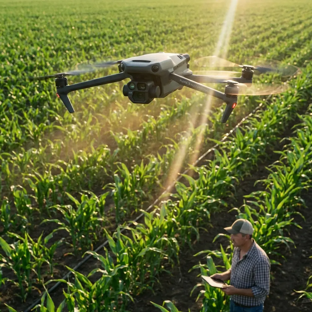
Remote wildlife survey work punishes weak aircraft in quiet ways.
Not with dramatic failures every day, but with small misses: a drifted hover near a tree line, a telemetry hiccup over uneven ground, a shaky zoomed-in frame that makes species identification harder than it should be, or dirty sensors that blunt obstacle awareness just when you need it most. When you are working far from roads, often with short weather windows and limited battery opportunities, those “small” details decide whether a mission produces usable evidence or a folder full of compromised footage.
That is the lens I would use to think about the Mavic 4 Pro for wildlife work in remote terrain.
The most useful way to evaluate it is not as a lifestyle camera drone, but as a compact field aircraft that borrows expectations from enterprise operations: flight stability, environmental sensing, dependable transmission, and camera behavior that remains useful when the pilot must keep a respectful distance from animals.
Start with the part many pilots skip: cleaning before takeoff
Before I talk about image quality or tracking, I want to start with a pre-flight step that matters more than many operators admit: cleaning the vision and sensing surfaces.
Remote wildlife survey flights often launch from dusty tracks, damp grass, sandy riverbanks, or scrubland where pollen and fine grit settle quickly. On aircraft that rely on multiple environmental sensing methods, that contamination is not cosmetic. The reference material describes a stack of perception tools working together: front and rear cameras, left and right infrared sensing, downward binocular vision, ultrasonic support, and even top-facing infrared in broader DJI sensing architecture. The operational point is simple. Safety and precision do not come from one sensor. They come from overlap.
That overlap only helps if those surfaces are clear.
A smudge on a forward vision sensor can reduce obstacle interpretation when crossing a broken canopy edge. Dust near downward cameras can interfere with low-altitude positional confidence during a careful hover above a nesting area. In wildlife work, where the pilot may hold position for observation rather than race through a route, that stability becomes part of the data collection chain. A clean aircraft is not just a maintenance virtue. It protects the very features people count on, especially obstacle avoidance and subject tracking.
So my field routine is blunt and short: inspect the camera glass, wipe visual sensors, check for dew or dust around the downward sensing area, confirm no residue near ultrasonic ports if present, then verify gimbal freedom before power-up. It takes two minutes and removes a surprising number of avoidable problems.
Why flight control quality matters more in wildlife surveys than spec-sheet readers think
Wildlife surveying in remote areas is often done by people who care most about the camera. That is understandable. But in practice, the flight controller carries the mission.
The source material highlights something DJI has long treated as an advantage in professional systems: flight algorithms refined through very large production volumes, then optimized for industry aircraft use rather than left as generic open-source adaptations. It also calls out redundant architecture such as dual IMUs, dual barometers, and dual signal outputs.
Even if the Mavic 4 Pro sits in a more portable class, those design values matter. They point to what experienced pilots actually feel in the air: calmer behavior in hover, less fuss during setup, better consistency when wind shifts over ridges or open marsh, and fewer odd tuning quirks that force the operator to compensate manually.
For wildlife survey missions, that operational significance is huge.
You may need to hold a visual stand-off distance while observing herd movement. You may need to creep laterally along a shoreline to count birds without changing altitude abruptly. You may need to frame an animal through gaps in branches, where overcorrection is the enemy. In those moments, stable flight control is not abstract engineering. It is the difference between recording behavior naturally and disturbing the scene by forcing repeated repositioning.
The reference text also makes a pointed comparison with competitors built on modified open-source flight control stacks, noting poorer stability, more difficult frame adaptation, and weaker wind performance after tuning. That matters in remote habitat work because survey teams do not want an aircraft that needs personality management. They want one that lifts, settles, and behaves predictably on every sortie.
Zoom changes the ethics and quality of wildlife observation
One detail in the source jumped out immediately: support for 30x optical zoom and 6x digital zoom, along with an extremely small stabilization envelope described as 0.01° and a claim that shooting error at 100 meters is only 17 mm.
Those numbers are not just marketing trivia. They describe a very practical wildlife advantage: seeing more while intruding less.
A remote survey pilot should not need to push the aircraft uncomfortably close to animals just to confirm what is in frame. Long-reach viewing lets you maintain stand-off distance, especially with skittish species or during breeding periods. If a camera system can preserve detail at distance and the stabilization is good enough to hold a usable frame, the aircraft becomes far more suitable for observational work rather than just scenic capture.
That is where the Mavic 4 Pro conversation gets interesting. Readers usually focus on cinematic modes like D-Log, Hyperlapse, or QuickShots because they are familiar keywords. For wildlife work, though, long-range observation and frame steadiness are more important than flashy motion presets. A zoom-capable platform lets the operator document nests, shoreline movement, or edge-of-forest activity without repeatedly closing in. That lowers disturbance risk and often produces more natural behavior on camera.
The near-infrared night vision note in the reference is also worth unpacking carefully. For civilian survey workflows, low-light assistance can support dawn or dusk observation windows, when many species are active and ambient light is poor. It does not replace ethical flight planning, and operators still need to respect local wildlife rules and daylight flight regulations where applicable. But in practical terms, better low-light visibility can extend useful observation conditions at the edges of the day, when standard visual footage would otherwise collapse into noise.
Transmission reliability is not glamorous until you lose it
Every wildlife operator remembers a mission where transmission quality became the real story.
The source material explains image transmission the right way: not just video, but a combined chain of image transfer, data transfer, and control transfer. That framing is more important than people think. When flying in remote terrain, the link is the aircraft’s working nervous system. You are not merely trying to see a live picture. You are preserving command confidence, telemetry awareness, and recording workflow.
The document also references DJI digital transmission versus analog systems, and notes regulatory frequency ranges including 2.4 GHz and 5.8 GHz, with Chinese power limits of 100 mW at 2.4 GHz and 1 W at 5.8 GHz including antenna gain. Those regulatory details do not tell us everything about a specific consumer aircraft in every region, but they do point to the operating reality: a robust digital link is central to field reliability.
For a remote wildlife survey, that matters in several ways.
First, digital transmission quality affects how accurately you can judge animal position and behavior in real time. Compression artifacts or unstable preview feeds can lead to misidentification or poor framing decisions. Second, dependable control feedback reduces pilot workload. If the operator trusts the link, they can focus on spacing, altitude discipline, and observation rather than second-guessing command latency. Third, stable data return supports cleaner mission records. In survey work, metadata and flight continuity often matter almost as much as footage.
This is one reason compact aircraft with mature transmission ecosystems tend to outperform “spec monsters” with weaker field behavior. Wildlife teams need confidence, not drama.
Obstacle avoidance is not there to make you reckless
One of the most misunderstood features in compact drones is obstacle avoidance. Newer pilots treat it as permission. Experienced field operators treat it as margin.
The reference material describes a layered sensing approach using cameras, infrared, ultrasonic sensing, radar in broader architecture, and systems such as RTK and ADS-B in the wider DJI ecosystem. The key phrase is that multiple methods are used to detect the external environment in support of precise, intelligent, and safe flight.
For wildlife surveying, obstacle avoidance should be used exactly that way: as layered environmental awareness, not a substitute for route judgment.
In remote habitats, the hard problems are not always obvious obstacles. Thin branches, reeds, sudden elevation changes, angled rock faces, and low-contrast backgrounds can make route planning more complex than a simple open-field flight. A Mavic 4 Pro equipped with modern obstacle sensing and intelligent tracking can be very effective when tracing animal movement along natural corridors or skimming above uneven terrain at controlled speed. But the real advantage is workload reduction. It gives the pilot more mental bandwidth to monitor the subject, watch battery state, and maintain legal and ethical operating distance.
This is also where ActiveTrack-style behavior has real survey value. Subject tracking is often framed for sports or content creation. In wildlife observation, careful tracking can help maintain consistent framing on moving animals without requiring constant stick micro-corrections. That said, this should be done conservatively. The objective is not pursuit. It is stable documentation with minimal disturbance.
Camera modes still matter, but not in the way travel creators use them
Let’s talk about the content tools people search for: D-Log, Hyperlapse, QuickShots, and subject tracking.
For survey professionals or conservation teams, D-Log can be valuable because it preserves more grading flexibility when lighting changes across open water, grassland, and tree cover in the same mission. You are not chasing cinematic drama. You are trying to hold detail in fur, feathers, shoreline texture, and habitat context. Better tonal control helps.
Hyperlapse has a narrower role, but it can be useful for environmental pattern recording: shifting herd positions across a meadow edge, waterbird congregation changes, or habitat activity over a fixed window. QuickShots are less central for formal survey tasks, though they may help outreach teams or conservation communicators build public-facing material from the same expedition. The point is that these modes become more useful when treated as documentation tools rather than social media tricks.
If you are designing a real field workflow around the Mavic 4 Pro, the hierarchy should look different from consumer reviews. Stability first. Clean sensing second. Transmission confidence third. Then camera flexibility.
A compact aircraft can still support disciplined survey methods
One reason the Mavic line continues to attract serious field users is that portability changes behavior in a good way. If the aircraft is compact enough to carry all day, it gets deployed more often during narrow opportunity windows: a break in wind, a brief appearance at a watering area, a sudden light shift over a nesting zone.
But portability only pays off if the aircraft can behave with enterprise-like discipline once airborne. That is why the reference document’s emphasis on integrated design and quality control matters. It mentions integrated thermal technology in broader DJI solutions, lightweight one-piece design, and stable imaging output. Even where a specific Mavic 4 Pro configuration differs from larger industrial platforms, the philosophy carries over: integration usually produces cleaner field workflow than patchwork setups.
For wildlife teams operating far from support vehicles or benches, that translates into fewer fiddly accessories, fewer alignment headaches, and less time exposed on site before launch.
The real field takeaway
If I were preparing a Mavic 4 Pro for remote wildlife survey work, I would not obsess over headline features first. I would build around a repeatable process.
Clean the sensing surfaces before every launch. Confirm obstacle sensing is unobstructed. Check the transmission environment. Keep enough stand-off distance to let zoom do the work. Use tracking gently, not aggressively. Favor stable, observant flying over cinematic bravado. Record in a format that preserves habitat detail. And judge every mission by one standard: did the aircraft help you observe without becoming the center of the scene?
That is where the source material is most useful. It reminds us that effective drone work is a system problem, not a single-camera problem. Dual IMUs and dual barometers matter because they support steadier flight. Multi-direction sensing matters because it supports safer route execution. A 30x optical zoom matters because it can reduce wildlife disturbance while improving evidence capture. A properly managed digital transmission link matters because image, data, and control are inseparable in field operations.
If you are planning a remote survey workflow and want a practical discussion around configuration and flight habits, you can message our field team directly on WhatsApp and compare notes before your next deployment.
The best wildlife drone flights are often the least theatrical ones. Quiet launch. Stable hover. Respectful distance. Clean data. Safe return.
That is the standard a Mavic 4 Pro should be measured against.
Ready for your own Mavic 4 Pro? Contact our team for expert consultation.