Mavic 4 Pro for Wildlife Surveys in Extreme Temperatures
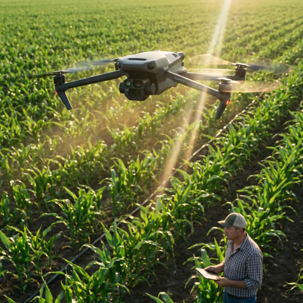
Mavic 4 Pro for Wildlife Surveys in Extreme Temperatures
META: A field-tested look at using Mavic 4 Pro for wildlife survey work in extreme heat and cold, with practical guidance on obstacle avoidance, ActiveTrack, D-Log, Hyperlapse, and handling electromagnetic interference through antenna adjustment.
Wildlife survey work punishes weak equipment and sloppy workflow. Extreme cold drains batteries faster than the spec sheet suggests. Heat softens timing margins, raises pilot fatigue, and turns every launch decision into a risk calculation. Add uneven terrain, reflective water, tree cover, and the occasional burst of electromagnetic interference from nearby infrastructure, and the aircraft is only half the story. The other half is how you fly it.
That is where the Mavic 4 Pro earns its place. Not because it is marketed as an all-purpose premium drone, but because the right mix of obstacle avoidance, subject tracking, color flexibility, and disciplined field handling solves real problems that show up when you are trying to document wildlife accurately without disturbing the habitat.
I approach this as a photographer first, but wildlife survey work demands more than beautiful footage. You need repeatability. You need enough image latitude to recover a scene that shifts from snow glare to shadow in seconds. You need tracking that helps hold a moving animal in frame without turning the mission into a reckless chase. And when signal quality wobbles because you are operating near metal structures or power equipment, you need to know that a small antenna adjustment can matter more than any menu setting.
The actual problem in extreme-temperature wildlife work
Most wildlife surveys fail long before a drone reaches its technical limit. They fail in the gap between conditions and operator decisions.
In cold environments, crews rush because hands go numb, batteries feel finite, and windows of animal activity are narrow. In hot environments, the pressure comes from thermal load, glare, and wind patterns that change by the minute. Either way, the pilot is trying to collect useful imagery while minimizing stress on the animals and avoiding the kind of abrupt maneuvering that ruins both data quality and trust in the aircraft.
The Mavic 4 Pro fits this scenario when it is treated as a precision survey platform rather than a sightseeing camera. Features like obstacle avoidance and ActiveTrack are not there to make flying easier in a casual sense. They are there to reduce workload when the environment is already consuming your attention.
If you are surveying birds along a scrubby ridge, for example, obstacle sensing matters because line-of-sight judgment degrades fast in shimmering heat or flat winter light. Branches, fence lines, and irregular rock outcrops become harder to read at distance. Strong obstacle avoidance gives you a second layer of protection, but the real operational significance is mental bandwidth. When the aircraft can better interpret space, the pilot can focus more on spacing from wildlife, composition, and route discipline.
Why tracking matters more than most pilots admit
Subject tracking in wildlife work is easy to misunderstand. It is not a license to tail an animal aggressively. Used properly, ActiveTrack helps maintain a stable visual relationship from a respectful distance, especially when an animal changes direction unexpectedly or disappears briefly against a textured background.
That matters in extreme temperatures because manual corrections become less precise as the pilot’s comfort degrades. In winter, gloves interfere with fine stick input. In summer, bright reflections and fatigue reduce reaction quality. A good tracking mode offsets some of that degradation. The benefit is not just convenience. It is consistency.
Consistency is what makes footage and observations usable later. If you are monitoring movement patterns, herd spacing, or behavior at a water source, steady framing helps reveal what happened rather than forcing the analyst to guess around erratic camera work. The Mavic 4 Pro’s tracking-related tools, including ActiveTrack, are valuable here because they support a smoother, less intrusive survey style.
I would still set hard boundaries. Never let tracking dictate the flight path. Wildlife welfare comes first, and your route planning should reflect that. ActiveTrack is an aid, not an excuse to crowd the subject.
D-Log is not just for cinematic work
A lot of operators hear “D-Log” and think grading suite, marketing reel, sunset shot. That is too narrow.
For wildlife survey missions in extreme environments, D-Log has practical value because these scenes often contain brutal contrast. Snowfields beside dark timber. Sunlit rock next to shaded burrows. Water reflections cutting across muddy shoreline. Standard profiles can clip highlights or bury detail right where biological evidence sits.
D-Log gives you more room to manage that contrast in post. The operational significance is straightforward: it increases the odds that fur pattern, feather detail, track markings, vegetation condition, or shoreline behavior remain visible after editing. When documentation quality matters, dynamic range is not an artistic luxury. It is evidence preservation.
The catch is workflow discipline. If your team shoots D-Log, your post pipeline must be ready for it. Exposure decisions in the field need to be deliberate. Metadata and mission notes need to be clean. Otherwise, the extra flexibility never turns into better output. On a serious survey job, image capture and post are one system.
QuickShots and Hyperlapse have a place if you use them correctly
These two features are often dismissed as “content tools,” but that misses their field value.
QuickShots can help gather repeatable contextual views around a habitat edge, nesting zone, or migration corridor. Not because the move is flashy, but because a controlled automated pattern can create visual consistency across multiple survey days. That consistency helps when comparing vegetation changes, access patterns, or water levels over time.
Hyperlapse is even more interesting for environmental interpretation. In extreme temperatures, animal activity windows can be brief and highly sensitive to light, wind, and thermal conditions. A carefully planned Hyperlapse sequence can reveal movement trends around feeding areas, thaw lines, shoreline access, or shade transitions that are easy to miss in real time. Used with restraint, it becomes a monitoring aid rather than a stylistic flourish.
The key is intent. If the output supports observation, comparison, or communication with researchers and land managers, these modes are useful. If they pull you away from survey priorities, leave them off.
The overlooked field skill: managing electromagnetic interference
Extreme-weather crews talk endlessly about battery temperature and wind. They talk far less about electromagnetic interference, even though it can be the thing that quietly degrades a mission.
Interference shows up in places people forget to suspect: utility corridors near wetlands, metal observation towers, remote research stations, vehicles parked too close to the takeoff point, and temporary field equipment with active radios. You may not lose control outright. More often, you see inconsistent link quality, hesitant video transmission, or orientation uncertainty that erodes pilot confidence.
This is where antenna adjustment becomes a practical skill, not trivia.
If you detect interference or weak signal behavior, the first response is not panic and not random stick movement. Reassess your position, check nearby structures, and adjust the controller antennas so their orientation better favors the aircraft rather than pointing them carelessly into dead angles. Small changes in pilot stance and antenna alignment can noticeably stabilize the link, especially when terrain or infrastructure is already complicating the radio environment.
That matters operationally for wildlife surveys because hesitation creates noise, both literal and procedural. A pilot who is second-guessing the link tends to make abrupt corrections, change altitude without a plan, or cut a route short before the data is complete. Good antenna discipline helps preserve smooth, quiet, predictable flight behavior.
I have seen this play out on edge habitats near metal fencing and service buildings. The aircraft itself was fine. The airframe did not need rescuing. What changed the mission was stepping several meters away from reflective structures, reorienting toward the aircraft, and adjusting antennas with intention instead of habit. Sometimes that simple reset is the difference between a clean final pass and a wasted deployment.
If your team runs into those field questions regularly, it helps to have a direct line for technical discussion and mission planning; I usually suggest using this WhatsApp support channel before heading into difficult terrain.
Building a better problem-solution workflow with Mavic 4 Pro
The strongest Mavic 4 Pro workflows start before takeoff.
For extreme-temperature wildlife missions, I would build the day around three layers: aircraft readiness, animal sensitivity, and environmental interference.
Aircraft readiness means more than charged batteries. In cold weather, keep packs warm until needed and shorten your confidence interval for each sortie. In heat, avoid long idle periods on the ground with systems powered unnecessarily. Review return path options before launch, not during a warning screen.
Animal sensitivity means planning stand-off distance and route geometry in a way that limits repeated passes. This is where obstacle avoidance helps. If the aircraft is better at sensing the environment, you can design smoother approaches that avoid sudden corrections near habitat edges. Tracking tools then become a way to maintain continuity without pressing closer than needed.
Environmental interference means reading the site the way a radio system would. Look for metal roofs, towers, power sources, vehicle clusters, temporary comms gear, and terrain that can block or reflect signal. If anything feels unstable, test antenna orientation early while the aircraft is close and the stakes are low.
These are not isolated checkboxes. They interact. A tired pilot in hot conditions is slower to notice interference. A cold-soaked crew is more likely to rush setup and forget antenna alignment. A rushed setup leads to weak link confidence, and weak link confidence leads to poor spacing around wildlife. The whole chain matters.
What makes the footage usable after the flight
A wildlife survey is not successful because the flight was smooth. It is successful because the material holds up under review.
That is why Mavic 4 Pro’s image flexibility matters. D-Log preserves tonal room for difficult scenes. Stable tracking helps maintain continuity on moving subjects. Obstacle avoidance reduces the kind of erratic near-miss flying that contaminates otherwise useful footage. QuickShots and Hyperlapse, when planned with discipline, add habitat context and timing insight.
The result is a stronger record. Not just prettier footage. A stronger record.
For a photographer, that distinction matters. Beautiful images can be persuasive, but survey material must also be interpretable. You want frames that show relationship: animal to terrain, movement to weather, habitat to time of day. The Mavic 4 Pro supports that when the operator resists the temptation to use every feature at once.
A realistic field example
Picture a dawn survey in a cold basin where elk are moving between tree cover and open ground. The frost is bright enough to push highlights hard, while the timber line drops into deep shadow. Manual framing alone would demand constant correction as animals move unpredictably. Gloves reduce dexterity. A utility service road nearby introduces intermittent interference.
This is where the aircraft’s feature set becomes practical in sequence.
First, obstacle avoidance adds confidence as you work along the edge of sparse trees and broken ground. Second, ActiveTrack helps keep a stable view of movement without overflying the animals. Third, D-Log protects the high-contrast scene so the frost line and coat detail survive post-processing. And when the signal begins to feel inconsistent near the road, a deliberate antenna adjustment and slight repositioning of the pilot restore steadier link behavior.
Each element is small on its own. Together, they produce something valuable: a calm flight that gathers usable information in difficult conditions.
That is the real argument for the Mavic 4 Pro in this kind of work. Not hype. Not broad claims. A set of tools that reduce friction in the field and improve what comes back from the field.
Final take
If your work involves surveying wildlife in punishing heat or cold, the Mavic 4 Pro makes the most sense when you lean into its operational strengths rather than its headline appeal. Obstacle avoidance reduces workload around complex terrain. ActiveTrack supports steadier observation from a respectful distance. D-Log protects difficult scenes that would otherwise lose detail. QuickShots and Hyperlapse can serve habitat documentation when used with intent. And antenna adjustment remains one of the simplest, most underrated answers when electromagnetic interference starts to undermine confidence.
Extreme environments expose weak habits fast. They also reward disciplined pilots with remarkably strong results. Used thoughtfully, the Mavic 4 Pro is not just capable of flying those missions. It helps make them calmer, cleaner, and more useful.
Ready for your own Mavic 4 Pro? Contact our team for expert consultation.