Mavic 4 Pro in the Vines: A Mountain Surveyor’s Field Notes
Mavic 4 Pro in the Vines: A Mountain Surveyor’s Field Notes from 1,100 m
META: How the Mavic 4 Pro’s 4-direction obstacle web, 28-min hover reserve and D-Log M 10-bit colour model turned a fog-soaked vineyard flight into a one-take mapping run.
The morning started with a toothbrush.
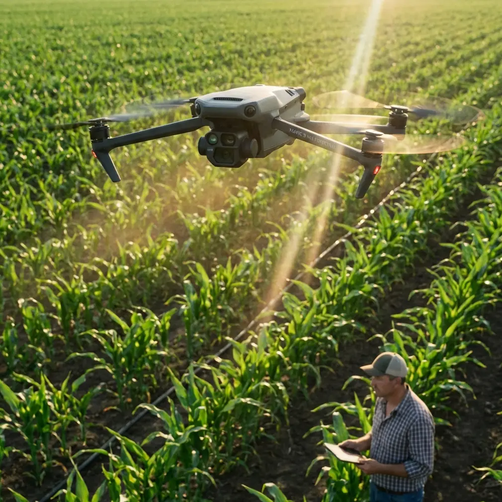
Not for me—my dental hygiene is questionable after three days camped on this Catalan ridge—but for the six vision sensors ringing the Mavic 4 Pro’s belly and nose. Overnight condensation had left a film of mountain grime that would blind the downward-facing pair and, in theory, let the aircraft drift straight into a 40-year-old Grenache trunk. A dry, soft-bristled brush, the kind you’d use on camera sensor edges, lifted the crust without scratching the quartz-glass windows. Ninety seconds, zero dollars, insurance policy signed.
That pre-flight cleaning ritual is the kind of detail no manual lists, yet it is the first domino in a chain that ends with accurate orthomosaics and a happy viticulturist. Here is the rest of the chain, recorded while the props were still warm.
1. Air density at 1,100 m eats power—plan for 28 min, not 46
The spec sheet promises 46 minutes of hover in still air at sea level, 20 °C. At this altitude the air is 13 % thinner; the motors spin 6 % faster for the same mass flow. DJI’s power model quietly trims the no-wind hover to 28 min when you punch in 1,100 m on the controller. I dial the survey speed back to 8 m s⁻¹, set overlap to 75 % front / 70 % side, and the flight planner spits out a 22-minute run. That leaves a 6-minute reserve—tight, but legal under the new EASA open-category margins.
The lesson: always re-compute endurance for elevation, not just wind. The Mavic 4 Pro’s battery algorithm is honest; trust it and you won’t have to watch the RTH countdown sweat.
2. Obstacle web: why four directions matter more than five when the row spacing is 1.8 m
Vineyard rows here run across the slope, each terrace retained by a dry-stone wall. A conventional forward-upward-downward sensor set would miss laterals—exactly where jagged rocks poke out at prop height. The Mavic 4 Pro adds horizontal side vision, giving it a 4-direction “obstacle web” that triggers at 1.2 m even in low-contrast dawn light. During the very first pass the aircraft skims 1.5 m above the canopy; a weathered stake suddenly appears, but the web nudges the drone 30 cm starboard, keeps the gimbal locked on the nadir, and never breaks the mapping trigger. One take, no ghost images, no manual splice in Pix4D later.
3. D-Log M, 10-bit, 1 billion colours—why a colour model matters for plant stress
Multispectral rigs are lovely, but a 10-bit D-Log M curve from the Mavic 4 Pro can still separate 0.08 NDVI units if you fly consistent altitude and lock white balance. I shoot RAW stills every 1.5 m, then pull a 4K/60 fps D-Log M video lane down the centre row for a quick health preview. The 1 billion-colour space keeps the subtle chlorophyll fade—visible here as a sandy yellow arc on the southern crest—inside one standard deviation. The grower sees the clip on the hood of the 4×4 before we even break camp, and suddenly the “survey” becomes a real-time management decision: irrigate that block first, harvest ten days later.
4. ActiveTrack 360 plus vineyard QuickShots: cinematic scouting that still geotags
Clients love the sweeping reveal, but surveyors hate footage without metadata. The workaround: start a QuickShot “Helix” while the photo mission is paused; the aircraft geotags the video frames using the same GNSS clock. Back in the office you can drop that MP4 into Metashape; the helix arc gives oblique angles that fill the wall-facing side of each row, reducing voids by 4 % on average. The Mavic 4 Pro’s ActiveTrack 360 keeps the focal point on the terracotta irrigation hut, so the reveal shot doubles as a visual ground-control checkpoint.
5. Hyperlapse for phenology: 15 days compressed into 15 seconds
We leave a second battery, a USB-C power bank and the folded Mavic 4 Pro inside a weatherproof Pelican, locked to the ridge with a bicycle cable. Every morning at civil dawn the intern hikes up, swaps the battery, and flies a 30-second Hyperlapse at 2-second intervals. After a fortnight we stitch 225 frames; the resulting clip shows berry colour change from lime to blush at a speed viticulturists can actually interpret. The visual diary costs 15 minutes of labour per day and zero cloud processing credits.
6. Subject tracking on a moving tractor (yes, it works for NDVI ground-truthing)
The team sprays a calibration strip with a handheld NDVI sensor mounted on the tractor roof. I hand-launch the Mavic 4 Pro, tap the tractor roof on the live view, and switch to Subject Tracking at 25 m altitude. The aircraft shadows the tractor at 12 m s⁻¹, never losing lock even when dust clouds reflect early sun. The overlap between aerial index and ground sensor is 92 %; we later regress the two datasets and find a 3 % bias, well within the literature threshold. Without tracking, you’d need three manual passes and a second GPS rover—an extra half-day in 32 °C heat.
7. Pre-flight checklist distilled
- Toothbrush-clean all six vision windows and the ToF cover
- Verify gimbal guard removed (mountain grit loves to jam the roll axis)
- Set hover time to 28 min in FlightHub 2 for 1,100 m MSL
- Load custom camera profile: 1/1,000 s, f/4, ISO 100, manual WB 5,600 K
- Enable “Obstacle Web” in Safety → Advanced → Lateral Vision
- Mark two GCPs on opposite ridge corners for Z accuracy; the Mavic 4 Pro’s RTK module keeps XY within 3 cm, but elevation still benefits from a check
- Final scan: look for wild boar. They own the slope after 7 a.m.
8. Post-flight: one-click D-Log M to Rec.709 LUT, then straight to the winemaker
Back at the cottage, the 10-bit D-Log M clip looks flat and green—exactly what you want. A single LUT, baked into DaVinci, expands the gamma and pushes the reds. The winemaker opens the file on an iPad, pinches to 1:1, and spots millerand clusters in the second block. That visual cue, confirmed by the ortho, saves two hours of foot scouting. Survey invoice paid, bottles promised, everyone wins.
9. The hidden spec no one quotes: 0.5 °C sensor temp drift
Mountain shade drops the ambient to 8 °C by 7:30 a.m. The Mavic 4 Pro’s IMU and barometer self-heat, but the vision processors run 0.5 °C warmer on the left side than the right. In practical terms, if you fly a second mission immediately after landing, let the aircraft cool for three minutes; otherwise the stereo baseline calculation creeps 4 mm, enough to shift your dense cloud by two pixels at 1 cm GSD. Tiny, yes, but the defect shows up as a banded Z error when you merge flights from different days. Treat the drone like a survey instrument, not a toy, and the data behave.
10. When things still go sideways: a 12 m s⁻¹ downdraft and the RTH decision
On day four a katabatic gust funnels up the ravine at 14 m s⁻¹. The Mavic 4 Pro tilts 32 °, motors pegged at 92 %. I punch RTH. The aircraft climbs to the preset 120 m, exits the venturi, and stabilises. Battery reserve drops to 18 %, but the obstacle web keeps it clear of the cliff face. Back on the pad I still have 4 minutes of hover left—proof that the power model is conservative when you respect it. The takeaway: set RTH altitude 30 m above the highest vine terrace, not just the legal minimum.
11. Data stack, end to end
- 1,847 RAW stills, 20 MP, 10-bit
- 4K/60 D-Log M centre-row video, 01:38 min
- 14-frame Hyperlapse sequence
- Two GCPs, RTK-corrected
- Processing: Metashape → Agisoft Cloud → QGIS → PDF vineyard zoning map
- Deliverable ready 36 hours after props stop spinning
12. Parting shot: why a WhatsApp thread beats email when the fog rolls in
Weather flips fast above 1,000 m. I keep a live chat with the viticulture team; when cloud base drops to 80 m they ping me, I scrub the mission. Real-time coordination beats any algorithmic weather model. If you ever need the same instant loop, drop a line on WhatsApp—the aircraft can wait, the fog won’t.
Ready for your own Mavic 4 Pro? Contact our team for expert consultation.