Surveying Remote Vineyards With the Mavic 4 Pro
Surveying Remote Vineyards With the Mavic 4 Pro: A Field Case Study From a Windy Afternoon
META: A practical Mavic 4 Pro vineyard survey case study covering obstacle avoidance, ActiveTrack, D-Log workflow, changing weather, and remote inspection tactics.
I took the Mavic 4 Pro into a remote vineyard block with a simple brief: document vine health, identify drainage trouble spots, and bring back footage that could help the grower make decisions without walking every row.
That sounds straightforward until you add distance, shifting light, uneven terrain, tree lines, and weather that refuses to hold still.
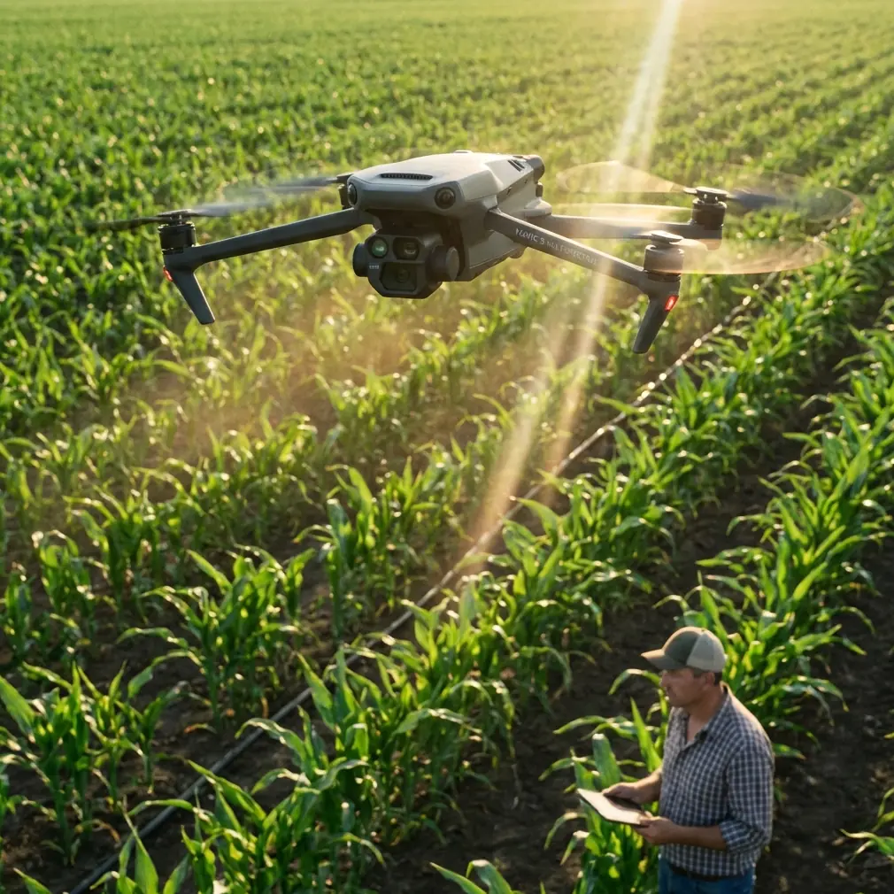
This particular site sat well off the main road, with rows running across a sloped section of ground and a patchwork of narrow access tracks. From the launch point, I could see why a drone mattered here. Covering the block on foot would have taken hours. Covering it from the air meant I could study canopy consistency, spot gaps in growth, and record the terrain context in a single session. The Mavic 4 Pro fit that job especially well because it sits in a useful middle ground: portable enough to carry into remote ground, but advanced enough to do more than just capture pretty overhead shots.
My goal was not cinematic content for its own sake. It was operational imaging with enough polish to be useful for both analysis and presentation.
Why the Mavic 4 Pro made sense for this vineyard job
Remote vineyard work demands more than a stable hover. You need a drone that can cope with repeated low-altitude passes, changing angles of light, and moments when you have to fly near rows, trellis structures, and bordering trees without losing confidence.
The Mavic 4 Pro’s obstacle avoidance is one of the reasons I trust it in agricultural environments where the danger is not a single dramatic object but a series of small, recurring hazards. Vines themselves are not tall enough to threaten the aircraft on a standard pass, but posts, wires, windbreak trees, utility lines near access roads, and unexpected elevation changes absolutely are. In a vineyard, safe flight is usually about managing dozens of little risks rather than one big one. Good sensing buys time. Time improves decisions.
That mattered halfway through this sortie, when the weather shifted.
I launched in relatively calm conditions under broken light. About 20 minutes in, the sky flattened out and a breeze started moving down the rows harder than expected. That kind of mid-flight change alters more than image aesthetics. It affects hover stability, return planning, battery management, and how aggressively you can run close inspection lines. Gusts also increase the risk of lateral drift near trees and edge vegetation. The Mavic 4 Pro handled the change with the kind of stability that keeps a working flight productive instead of forcing an early pack-up. I tightened my route, raised the safety buffer on edge passes, and continued collecting usable data rather than gambling on precision that the conditions no longer supported.
That distinction matters in real operations. A drone is valuable not when the air is perfect, but when the aircraft gives you enough margin to adapt once conditions stop cooperating.
The flight plan: broad mapping first, close inspection second
For this vineyard, I broke the mission into three passes.
The first pass was high and slow. I wanted a visual map of the property layout, row orientation, access points, and the drainage pattern across the slope. Even a short overhead sequence can reveal subtle inconsistencies in vigor when one section of the block reflects light differently from another. From above, the vine rows formed clean lines except for a few irregular patches where growth density dropped off. That immediately told me where to spend more battery time.
The second pass moved lower and followed selected rows at an oblique angle. This is where subject tracking features like ActiveTrack become more useful than many operators realize. Most people associate tracking with sports or moving vehicles. In fieldwork, I use it differently. If I am walking an access lane or moving alongside a tractor path at the vineyard edge, ActiveTrack can help maintain framing while I focus on route awareness and obstacle spacing. It is not a replacement for pilot judgment. It is a workload reducer. In a remote environment, reducing cognitive load matters because your attention is already split between wind, terrain, battery status, visual line of sight, and the changing geometry of the rows.
The third pass was for detail. I used slower movements to inspect sections that looked stressed from the earlier overview. This is also where the Mavic 4 Pro’s image flexibility pays off. Shooting in D-Log gives me more room when the light shifts quickly between bright breaks and muted cloud cover. That was exactly what happened here. The weather transition compressed contrast one minute and opened it up the next. A flatter capture profile preserved information in both the vine canopy and the lighter soil paths, making it easier to review footage later for actual field clues rather than just visual drama.
If your output needs to support decisions, not just social clips, that latitude matters.
What changed when the weather turned
The wind came in uneven pulses, not a steady wall. That is often harder to manage because the aircraft is constantly correcting rather than settling into one predictable pattern.
When the first stronger gusts hit, I stopped trying to thread tight lateral lines near the outer tree boundary. That is where obstacle avoidance became operationally significant, not just a spec-sheet talking point. In a vineyard edge environment, branches can protrude irregularly, and gusts can push the drone toward them at exactly the wrong moment. The aircraft’s sensing system gave me an extra layer of confidence, but I still widened my stand-off distance and changed my camera angle instead of insisting on the original path. The result was safer flying and footage that remained useful.
This is a point many newer pilots miss. A capable avoidance system should not tempt you into reckless proximity. It should help you stay conservative while preserving mission success.
The weather shift also changed how I thought about battery reserve. In remote survey work, you never want your return margin calculated for the conditions you had at launch if those conditions are gone. I cut one nonessential creative pass and prioritized a clean final sweep over the most irregular rows. That gave me enough battery confidence to land without squeezing the numbers.
This is one of the strongest practical arguments for the Mavic 4 Pro in agricultural field use: when conditions become less cooperative, the platform still gives you room to make disciplined choices.
Reviewing vine health from the footage
Back on the ground, the footage told a clearer story than an eye-level walk would have.
From the overhead sequences, I could see subtle inconsistency in canopy density along one section where the slope changed and water runoff appeared to accelerate. On the lower oblique passes, a few rows showed a less uniform leaf mass than neighboring blocks. That kind of contrast does not diagnose a problem by itself, but it does narrow the conversation. Instead of saying, “something seems off in the back block,” you can point to a repeatable visual pattern across a specific area.
For growers managing remote parcels, that is useful because it sharpens where to spend limited inspection time once boots are on the ground.
The footage also helped separate visual noise from meaningful irregularity. A gusty day can make vines look more chaotic than they are. By flying multiple angles and keeping movement controlled, I was able to confirm that some differences were structural in the block rather than just wind animation in the canopy. That is another reason stable capture matters in field analysis. The cleaner the platform holds its line, the easier it is to trust what you are seeing.
Using QuickShots and Hyperlapse without wasting flight time
I did use QuickShots and a short Hyperlapse sequence, but not as filler.
QuickShots can be genuinely useful when you need a fast contextual clip showing how a vineyard block sits within surrounding terrain. A short automated move can establish road access, elevation, neighboring vegetation, and exposure to wind. For a grower sharing updates with partners, consultants, or an off-site management team, that kind of visual context is more informative than a flat overhead still.
Hyperlapse has a narrower role here, but I still see value in it when weather is part of the story. In this case, the sky change over the property helped illustrate why the later footage looked different from the opening passes. A short time-compressed sequence made that shift obvious. It showed the clouds building and the light hardening over the rows. That is not just atmospheric storytelling. It explains the operational context behind the footage and supports more honest interpretation of what the camera captured.
Still, both tools are secondary. In vineyard survey work, automation features should support the mission rather than dominate it.
Lessons for operators surveying remote vineyards
A few things stood out from this flight.
First, launch position matters more than people think. I chose a spot with a clean view down several row lines and enough open space to recover safely if the wind increased. In remote terrain, the best launch site is rarely the closest one. It is the one that preserves options.
Second, plan for changing weather even on short flights. My session only needed about 20 minutes before the conditions began to shift noticeably, and that was enough to force route changes. If you are surveying vineyards in exposed ground, assume the weather you start with may not be the weather you finish with.
Third, obstacle avoidance is most valuable when paired with restraint. Tree edges, poles, and uneven terrain are where vineyard jobs become expensive if your judgment slips. Let the aircraft protect you, but do not use that protection as permission to fly lazily.
Fourth, use D-Log when you expect unstable light. It gives you more freedom to recover detail and maintain consistency in review. For anyone delivering imagery to a grower, land manager, or consultant, consistent footage is easier to compare and discuss.
Fifth, tracking tools like ActiveTrack can reduce workload in edge-of-field movement, but they are not an excuse to stop piloting actively. In agricultural spaces, the environment changes too quickly for blind trust.
If you are planning a similar operation and want to compare field setups or workflow ideas, you can message me here.
The bigger takeaway from this flight
What stayed with me from this vineyard session was not a single dramatic shot. It was how quickly the Mavic 4 Pro moved from image-making tool to decision support tool.
That is the real value in a drone like this for remote agricultural work. It compresses distance. It reveals patterns that are hard to read from ground level. It keeps the operator productive when light and wind stop behaving. And when used carefully, features like obstacle avoidance, ActiveTrack, QuickShots, Hyperlapse, and D-Log are not gimmicks. They solve different parts of the same problem: getting clearer information out of a landscape that is large, uneven, and constantly changing.
The weather swing during this flight made that especially clear. Under calm conditions, many drones can produce decent-looking footage. Once the air gets unsettled and the route has to change on the fly, the platform either helps you stay methodical or it starts eating into your attention. The Mavic 4 Pro stayed in the first category, which is exactly where a working drone needs to be.
For remote vineyard surveying, that reliability is not a luxury. It is the thing that turns a short flight into useful field intelligence.
Ready for your own Mavic 4 Pro? Contact our team for expert consultation.