Mavic 4 Pro on Solar Farms at Dusk: What Actually Matters
Mavic 4 Pro on Solar Farms at Dusk: What Actually Matters in Low-Light, High-Interference Work
META: A field-focused look at using Mavic 4 Pro around solar farms in low light, with practical insight on obstacle awareness, signal stability, and why VTOL thinking still shapes modern UAV operations.
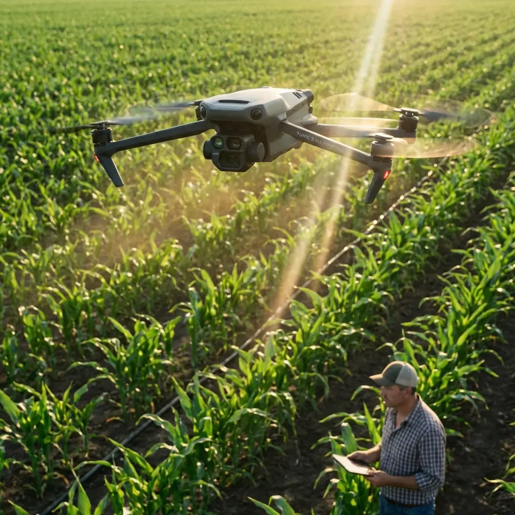
Solar farms look simple from the road. Endless rows. Repetition. Clear geometry. Then you step onto one at first light or near sunset and the job changes completely.
The light is thin. Panel surfaces throw back uneven reflections. Service roads cut between arrays with little room for error. The site itself can become a difficult radio environment, especially when long metallic rows, inverters, fencing, and utility infrastructure begin to affect how confidently the aircraft talks to the controller. If your goal is precise aerial observation, documentation, or operational planning around spraying work on a large solar installation, the aircraft has to do more than produce a pretty image. It has to stay readable, predictable, and stable when the conditions are not.
That is where the conversation around Mavic 4 Pro gets more interesting than a simple feature roundup.
As a photographer, I care about image quality. But on industrial sites, image quality only matters after the aircraft earns the right to stay in the air safely and collect usable data. Around solar farms in low light, the real question is not whether the drone can fly. Most modern drones can. The real question is whether it can maintain clean situational awareness in an environment that is visually deceptive and sometimes electronically messy.
Why solar farms are harder than they look
Low-light work on solar sites combines several small problems into one large one.
First, contrast can collapse fast. In the last half hour before sunset, panel rows can merge visually into dark bands, while access tracks remain bright enough to fool exposure. For a pilot relying on the live view to assess spacing, wire runs, maintenance vehicles, and worker positions, this matters. A drone that preserves detail in both shadow and highlight gives you more than a better shot. It gives you better judgment.
Second, the geometry of a solar farm can become monotonous. Long, repeating lines make it easier to lose visual orientation, especially when moving laterally over several blocks of panels. Subject tracking and route consistency start to matter here, not for cinematic reasons, but because repetition is where human attention drifts.
Third, and this is less discussed outside field teams, signal confidence can fluctuate around infrastructure-heavy sites. I have seen cases where a small change in operator position or antenna angle cleaned up an unstable link almost immediately. Electromagnetic interference is not always dramatic. Sometimes it shows up as intermittent hesitation, a noisy image feed, or control lag that is just subtle enough to tempt you into ignoring it.
That temptation is expensive.
The operational lesson hidden inside older VTOL history
At first glance, a historical note about VTOL aircraft may seem unrelated to a compact platform like Mavic 4 Pro. It is not.
One of the more useful lessons from civil UAV development is that the market did not move toward vertical takeoff and landing by accident. According to the reference material, the UK company Aesir introduced a series of new VTOL UAVs at a European UAV conference in Peterborough on July 22–23, 2009. Less than 10 years later, rotorcraft with VTOL capability had spread globally, especially in the consumer segment.
That speed of adoption tells you something fundamental: operators value aircraft that reduce launch friction.
The same source also explains why the next phase of UAV design leaned into hybrid thinking. Multirotor aircraft were easy to deploy and easy to control, but endurance remained a core limitation. Fixed-wing platforms solved the endurance problem, yet often demanded runways, catapults, or awkward recovery procedures. For industry users needing takeoff in complex environments while still wanting strong endurance and payload performance, engineers began transferring vertical takeoff capability into fixed-wing systems.
That design logic matters even when you are flying something far smaller than a VTOL fixed-wing aircraft. Solar farms are exactly the kind of environment that reward minimal launch complexity. You may be working beside fencing, parked utility vehicles, inverter pads, gravel tracks, and restricted access corridors. The older industry push toward “take off in complex conditions” remains relevant because it describes the same operational priority modern compact drones now satisfy so well: get airborne safely without needing infrastructure.
The reference also highlights a key engineering point about composite-wing VTOL aircraft: by combining multirotor and fixed-wing design without a complex conversion mechanism, they achieved both vertical takeoff and high-speed cruise with relatively simple structure and high reliability. Operationally, that matters because reliability is often the hidden currency behind every successful mission. Simpler systems usually mean fewer transition risks and fewer field surprises.
Mavic 4 Pro is not a fixed-wing hybrid, but the buyer evaluating it for solar farm work should understand this lineage. The reason compact camera drones dominate site documentation today is not only portability. It is because the market spent years learning that crews need aircraft that can launch almost anywhere, recover almost anywhere, and still maintain dependable results in imperfect environments.
What Mavic 4 Pro needs to do well on this kind of job
For dusk and dawn work around solar arrays, I would judge the aircraft in four layers.
1. Live-view clarity under compromised light
If you are documenting vegetation around panel rows before or after spraying operations, or inspecting coverage access paths in low light, tonal control becomes practical rather than artistic. This is where D-Log style capture workflows can help preserve information across a difficult scene. Not because every industrial operator wants to grade footage like a film project, but because preserving highlight and shadow latitude can make later review far more useful.
You may be checking whether vegetation encroachment is concentrated along drainage channels. You may be comparing one block of arrays against another where shadow falls differently. Flat, flexible capture can support that analysis better than overcooked contrast.
2. Obstacle awareness that remains trustworthy around repeating structures
Obstacle avoidance sounds simple in a product sheet. On a solar site, it is not simple at all.
The aircraft has to interpret repeating rows, occasional gaps, tilted surfaces, perimeter fencing, and maintenance equipment. Low-angle light can complicate sensor interpretation because reflections change as the aircraft yaws or descends. This is where obstacle awareness is not just a safety backup. It becomes part of how confidently you can work lower and slower near infrastructure while preserving a margin.
I would still never treat obstacle avoidance as permission to get careless. But on a site where one misjudged lateral move can bring the aircraft too close to a row edge, reliable sensing matters.
3. Stable tracking for repetitive survey passes
Features like ActiveTrack and subject tracking are often framed for creators. On industrial ground, they become workflow tools.
If you are following a utility vehicle along service lanes, recording a technician route, or repeating a movement pattern across a section of the site, tracking reduces the amount of manual micro-correction you need to do. That lowers pilot workload. Lower workload usually means better decisions, especially in marginal light.
QuickShots and Hyperlapse are not the first functions most solar operators think about, but they can still have practical value. A controlled Hyperlapse, for example, can show how worker movement, vehicle circulation, or changing shadows affect access conditions across a large site in a compressed visual sequence. It is not a novelty if it answers an operational question clearly.
4. Link stability in an electrically busy environment
This is the one that tends to separate a smooth mission from an uncomfortable one.
On a solar farm, if the image feed starts to break up or control response feels inconsistent, stop assuming it is random. Reassess your position. Adjust your antenna orientation. Move a short distance to change the angle through which the signal is passing relative to rows, metallic structures, or nearby equipment. In my experience, a modest antenna adjustment can completely change the quality of the link.
That is why pilot discipline matters as much as hardware quality. Even the best aircraft benefits from an operator who understands signal geometry.
A simple field habit helps: before launching the mission segment that matters most, hover briefly at a safe altitude, yaw slowly, watch the feed, and note whether a certain heading degrades stability. If it does, reposition before committing to the run. Around reflective infrastructure, prevention beats troubleshooting in the middle of a pass.
Why the launch-and-recovery question still matters
The reference document makes another point that deserves attention: fixed-wing aircraft historically brought stronger endurance, but their takeoff and landing demands created operational pain. Some needed runways. Some required catapult launch. Recovery could be awkward, and without protection systems there was a real risk of crash damage.
That old tradeoff explains why compact multirotor platforms remain so useful for solar sites, even when endurance is not class-leading compared with larger aircraft. When you are operating in a narrow corridor near arrays or on a maintenance access strip, the value of vertical launch and recovery is immediate. You do not need open runway space. You do not need a recovery pattern that risks nearby structures. You can work from constrained positions and adapt as crews move.
The reference even describes how the advantage of runway-free operation significantly expanded UAV use in mountains, hills, jungles, and dense built environments. Solar farms are not mountains or jungles, but the principle is identical. Complex operating space rewards aircraft that do not need extra operating space.
That is one reason Mavic-class aircraft continue to make sense for site imaging tied to vegetation control, perimeter assessment, and progress documentation. They align with the same field logic that pushed the industry toward VTOL capability years ago: practical deployment beats theoretical efficiency when the site itself is the limiting factor.
A realistic workflow for low-light solar missions
If I were planning a Mavic 4 Pro mission for a solar farm near sunset, I would build the workflow around the environment rather than the camera spec sheet.
Start with a short perimeter walk. Identify inverter cabinets, overhead lines, parked equipment, and reflective choke points where control signal might get messy. Pick a launch point that gives the controller the cleanest line into the work area rather than the most convenient standing position.
Then run a short systems check in the actual light you will be working in. Not broad daylight. Actual low light. Watch how the live view renders dark panel rows versus service roads. Confirm that obstacle sensing behavior is predictable before moving into tighter geometry.
If tracking a moving subject or vehicle, use ActiveTrack only after confirming that the subject remains distinguishable against the panel background. Repetition can confuse both human eyes and automated systems. If the site pattern starts to visually swallow the subject, switch back to manual control before the aircraft has to guess.
For signal integrity, treat antenna alignment as an active part of piloting. If you need a quick field second opinion on setup or workflow, I’d point crews to this direct WhatsApp line for Mavic 4 Pro operational questions rather than letting a minor interference issue ruin a whole evening window.
Finally, capture with post-review in mind. If the footage may be used to evaluate vegetation encroachment, access conditions, or service coordination around future spraying work, preserve enough dynamic range and scene consistency that the video remains useful after the mission, not just during it.
The bigger takeaway
The most useful way to think about Mavic 4 Pro for solar farm work is not as a flying camera with a few smart features attached. It is a compact answer to an old industrial aviation problem: how do you launch quickly in constrained conditions, maintain enough awareness to work safely, and bring back usable results when the environment is pushing against you?
That is the same problem civil UAV design has been solving for years. The 2009 Aesir VTOL milestone and the industry’s subsequent move toward aircraft that combine easy takeoff with stronger mission performance were not side notes. They were signs of what operators truly needed.
Today, on a solar farm at dusk, those needs are still the same. Clean deployment. Reliable control. Useful imagery. Minimal drama.
When Mavic 4 Pro is judged against that standard, the conversation becomes far more grounded—and much more relevant to real field work.
Ready for your own Mavic 4 Pro? Contact our team for expert consultation.