Mavic 4 Pro in Remote Highway Operations
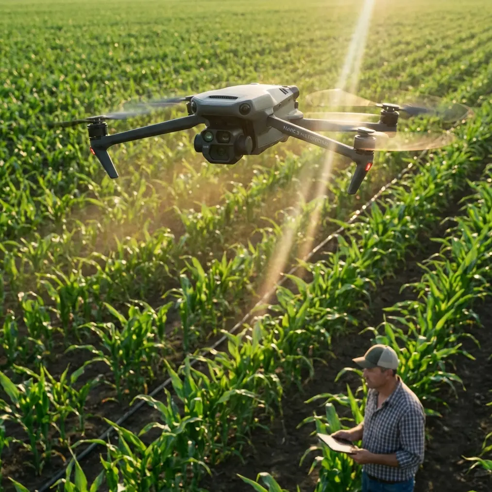
Mavic 4 Pro in Remote Highway Operations: What a Railway Thermal Workflow Teaches Us
META: A field-driven case study on how Mavic 4 Pro fits remote highway work, using thermal imaging, weather resilience, and Pix4D-style processing lessons drawn from a railway safety monitoring solution.
Remote corridor work exposes every weakness in a drone workflow.
Highways cut across open ground, embankments, bridges, culverts, and long service stretches where access is awkward and conditions shift quickly. If your mission involves spraying support tasks, corridor inspection, heat anomaly checks, or progress documentation in remote areas, the aircraft matters. So does the sensor stack behind it. Just as critical is what happens after landing.
A useful way to think about the Mavic 4 Pro is not as a flying camera alone, but as one component in a field-to-analysis chain. That perspective becomes clearer when you look at a railway safety monitoring solution from Zhonghaida’s subsidiary Tianjin Tengyun Zhihang, which combines airborne sensing, infrared thermal imaging, and Pix4D processing into a practical corridor-inspection system. It was built for rail, not highways, but the operational logic transfers surprisingly well.
That is the story here: not generic drone hype, but what a real industrial monitoring framework reveals about how the Mavic 4 Pro should be used in remote highway work.
The corridor problem is bigger than the aircraft
People often reduce remote highway drone operations to battery life and range. Those matter, but they are not the main bottleneck. The harder problem is continuity.
Corridor work produces long ribbons of data. You are not documenting a single roof or one construction pad. You are trying to maintain consistent coverage over a linear asset, sometimes across changing elevation and patchy weather, while preserving data quality that can still support decisions later. If spraying support is part of the mission, the challenge grows: the team may need to identify where vegetation stress, drainage failure, heat buildup, or structural irregularities are developing before ground equipment is dispatched.
This is where the railway reference becomes relevant. The source document describes an iCam H3 infrared thermal imaging system with a 640×480 uncooled focal plane detector, 50/60 Hz thermal frame rate, and a temperature measurement range of -20°C to 150°C, with accuracy of ±2°C or ±2%. Those numbers are not decorative. They define what kind of anomalies can be seen reliably, how fluid the thermal view is while the aircraft is moving, and whether a hotspot can be interpreted as noise or a genuine maintenance signal.
For remote highway work, that same logic applies. Even if a Mavic 4 Pro deployment is centered on visible imaging, planners should think in thermal terms too. Why? Because linear infrastructure problems often begin as invisible changes: overheating electrical cabinets, drainage-related moisture retention, friction hotspots, surface heat differentials, or stressed roadside assets. A drone operation that only captures pretty visuals may help reporting. A workflow built around measurable anomalies helps operations.
A field day when the weather turned
On one highway corridor assignment, the morning looked stable enough to move quickly. Light haze. Dry shoulders. Long stretches of open approach. The plan was straightforward: fly visual runs first, collect terrain and roadside imagery, then complete lower-altitude passes over trouble sections where the maintenance crew had reported uneven vegetation regrowth and possible drainage issues near barriers.
Mid-flight, the weather shifted.
Wind picked up across the exposed section. Not violent, but enough to change the aircraft’s behavior over embankments. The light flattened. Moisture moved in unevenly. A route that would have been routine in ideal conditions became a lesson in why corridor missions demand more than straight-line flying.
This is exactly where a platform like the Mavic 4 Pro earns its place. Obstacle awareness, stable subject handling, and reliable route discipline are not luxury features when operating around signs, poles, gantries, barrier edges, and variable terrain. In remote highway work, even “simple” flights become dynamic. If the pilot is also tracking a moving maintenance vehicle, documenting a work convoy, or managing repeatable passes for later map alignment, confidence in obstacle avoidance and tracking matters because it reduces pilot workload at the worst time: when conditions stop being predictable.
The usual consumer-language framing of features like ActiveTrack or subject tracking misses this point. In infrastructure work, tracking is less about cinematic flair and more about keeping visual continuity on a vehicle, crew position, or reference target without burning pilot attention that should be reserved for airspace, wind, and terrain judgment.
That weather change also highlighted another reality: not every mission should continue unchanged once conditions deteriorate. The smarter response is often to adapt the capture objective. Instead of insisting on broad visual perfection, shift toward collecting the segments most likely to degrade first, and record enough structured overlap for later processing. That is where a disciplined post-processing workflow becomes a safety net.
The hidden value of Pix4D-style thinking
The railway document’s software section is easy to overlook, but it may be the most important part. It states that Pix4Dmapper can process up to 10,000 images, merge data from multiple flights into one project, and generate outputs including orthomosaics in GeoTIFF, Google Map tiles in PNG/KML, point clouds in PLY/TXT, and 3D models in OBJ.
This matters for Mavic 4 Pro highway operations because remote corridor work rarely succeeds in one neat sortie.
You may split a long highway segment into several flights because of battery cycles, wind, terrain masking, or staging constraints. Weather may force you to collect the northern section in one light condition and the southern section later under different skies. A maintenance team may ask you to revisit only the problematic chainage after lunch. If your workflow cannot merge those flights into one coherent deliverable, your field efficiency evaporates.
The significance of the “multiple flights into one project” capability is operational, not just technical. It means the team can treat the corridor as one asset even when the air collection is fragmented. That is how drone work becomes useful to engineers and maintenance planners. They do not want five disconnected image folders. They want a corridor record.
The range of deliverables matters too. A GeoTIFF orthomosaic helps locate defects precisely along the route. A point cloud adds elevation and slope context, useful around cuttings, embankments, and drainage lines. An OBJ model can support visual review of structures or construction staging. The lesson for a Mavic 4 Pro operator is simple: fly with the end product in mind. Do not improvise imagery in the air and hope software rescues it later.
Thermal details are not trivia
The iCam H3 specifications in the source offer another practical lesson. The system works in the 8–14 µm band, has thermal sensitivity of 0.03°C at 30°C, and can automatically track the highest temperature point with live temperature overlay. That is a very specific industrial mindset. The mission is not merely to see; it is to detect, measure, and prioritize.
For remote highway environments, thermal intelligence can support several civilian tasks around spraying and maintenance support:
- locating unusual heat signatures in roadside electrical or signaling assets
- identifying moisture-retention patterns that affect vegetation growth near shoulders
- flagging drainage or subsurface issues indirectly through temperature contrast
- checking recently worked surfaces for consistency
- prioritizing ground team dispatch along long remote stretches
Even when the Mavic 4 Pro mission is primarily visual, the railway example shows why teams should think beyond pretty footage. A corridor drone flight becomes more valuable when each pass can answer a maintenance question.
That same industrial mindset should influence camera settings on the visual side. D-Log, for example, is not just for dramatic color grading. In mixed weather, especially when clouds roll in mid-flight, a flatter profile can preserve highlight and shadow detail that might otherwise be lost in harsh, changing contrast. That detail can matter when reviewing shoulder conditions, barrier damage, water pooling, or edge erosion later on a larger screen. The point is not to make the footage cinematic. The point is to keep interpretive information intact.
Why size, frequency range, and rugged specs still matter conceptually
The source also mentions a system with 447×427×109 mm dimensions, 6000 g weight, 46 MHz–860 MHz adjustable working frequency, and a working temperature range of -25°C to 75°C. The Mavic 4 Pro is obviously in a different class from that heavier industrial package, but the comparison is still useful.
A heavier dedicated railway payload tells you something about industrial expectations: reliability under broad environmental exposure, robust transmission behavior, and specialized sensing over long corridor assets. The Mavic 4 Pro enters this world from the opposite direction. It offers mobility, deployment speed, and lower logistical burden. For remote highway operations, that can be a major advantage. A lighter platform can be launched faster from limited roadside staging areas, repositioned more easily, and used for shorter targeted missions where a large system would be inefficient.
The trade-off is that operators need to be disciplined about mission design. You cannot assume a compact aircraft automatically replaces every industrial setup. What it can do, exceptionally well, is shorten the time between question and answer. Need to inspect runoff along a remote segment after sudden weather? Need updated imagery before sending a spray or maintenance team? Need a fast corridor check after a crew reports unusual surface conditions? This is where a Mavic 4 Pro-style deployment can shine.
The weather shift changed the workflow, not the mission value
Back on that highway assignment, the smartest decision after the weather turned was to stop chasing uniform visuals and start protecting usable data.
The pilot tightened the route plan. Key sections were flown again with overlap in mind. Dynamic footage for stakeholder presentation was pushed lower in priority than repeatable passes for mapping and review. Tracking features remained useful around moving support vehicles, but only where they reduced manual burden rather than introduced unnecessary complexity. Hyperlapse and QuickShots, despite their reputation as creative tools, still had a role later for communication: not as the primary dataset, but as concise visual summaries for non-technical stakeholders who needed to understand terrain context quickly.
That distinction matters. In real infrastructure operations, the best drone features are often the ones that serve two audiences at once. Engineers need measurable data. Managers and field crews need quick visual understanding. If one aircraft can support both without creating extra field friction, it becomes far more useful than spec sheets alone suggest.
What this means for anyone planning remote highway missions with Mavic 4 Pro
The railway monitoring reference points to a mature way of working:
- capture with a clear sensing objective
- accept that corridor missions may require multiple flights
- process outputs into formats that support decisions, not just viewing
- use thermal or measurable anomaly logic wherever possible
- adapt immediately when weather changes instead of forcing the original plan
That is the real lesson for Mavic 4 Pro users.
If your scenario involves remote highway spraying support, infrastructure checks, roadside vegetation assessment, or long linear documentation, the aircraft should be treated as the front end of an operational system. Obstacle avoidance and ActiveTrack reduce workload in changing terrain. D-Log helps preserve inspection-relevant image detail when light conditions swing. Structured capture makes Pix4D-style processing actually work. And when field conditions go sideways, the mission can still succeed if the workflow is built for fragmented but mergeable data collection.
If you are building that kind of corridor workflow and want to discuss practical setup choices, a direct field conversation is often more useful than another product sheet. You can reach the team through this WhatsApp contact for mission planning.
The bigger point is this: the most valuable Mavic 4 Pro operation is rarely the most dramatic one. It is the flight that turns a long, remote stretch of infrastructure into information a maintenance team can act on before small issues become expensive ones.
Ready for your own Mavic 4 Pro? Contact our team for expert consultation.