Mavic 4 Pro Field Report: Scouting Remote Highways
Mavic 4 Pro Field Report: Scouting Remote Highways with a Port-Grade Efficiency Mindset
META: A field report on using Mavic 4 Pro for remote highway scouting, with practical flight altitude guidance, obstacle avoidance workflow, and lessons drawn from a 5G remote-control industrial port case.
I spend a lot of time thinking about what separates a drone that merely captures footage from one that actually improves field decisions. For remote highway scouting, that difference is not image quality alone. It is repeatability. It is operator workload. It is whether the aircraft helps one person cover long stretches of road with stable, usable data instead of forcing the pilot into constant manual correction.
That is why the most interesting lens for evaluating the Mavic 4 Pro is not the usual hobbyist checklist. A better benchmark comes from heavy industry, where remote operations are judged by measurable gains in staffing, safety, consistency, and energy use. One port-side 5G and drone-enabled control case from Guangdong offers a useful framework. In that project, remote monitoring and dispatch consolidation was expected to reduce each shift to just 3 people, cutting 8 positions and saving an additional 1.6 million yuan annually after workflow optimization. Even before that final stage, the operation cited labor savings of 4.4 million yuan per year. Those are not camera specs. They are proof that remote visibility, when it is stable enough, changes how work gets organized.
That same principle matters when you are scouting highways in remote terrain with a Mavic 4 Pro.
Why a port automation case matters to highway drone scouting
A coal terminal and a highway corridor are obviously different environments. One is fixed infrastructure packed with conveyors, stackers, and ship-loading workflows. The other may stretch for kilometers through hills, sparse utility access, and uncertain weather. But the operational problem is surprisingly similar: how do you supervise a large physical area with fewer people exposed to hazards, while keeping output consistent?
The Guangdong project reported flow stability controlled within ±8%, and reclaiming efficiency improved by 3 to 5% compared with manual averages over a year of use in a comparable port setting. That detail is easy to overlook, but it is the heart of the story. Stability matters because a remote operator can only act decisively when what they are seeing behaves predictably. For highway scouting, that translates into flight paths that are smooth enough to compare one section of road against another, subject tracking that does not lose vehicles or work crews the moment the scene becomes visually busy, and obstacle avoidance that reduces the cognitive load of flying along poles, embankments, bridge approaches, and tree lines.
The Mavic 4 Pro fits this kind of work best when it is treated as a field instrument rather than a flying camera.
My field setup for remote highway scouting
When I am scouting a remote highway route, I divide the mission into three passes:
- High overview pass for terrain context and route continuity
- Mid-altitude inspection pass for lane condition, shoulder encroachment, drainage, and roadside obstacles
- Targeted low-altitude pass only where a closer look is genuinely needed
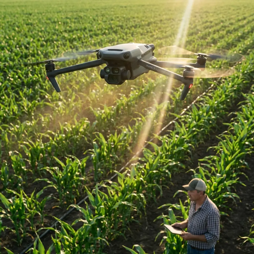
The biggest mistake I see is flying too low too early. It feels more cinematic, but it is less efficient and often less safe. For most remote highway scouting, my practical starting altitude is 60 to 90 meters above ground level. That range usually gives the Mavic 4 Pro enough separation to let obstacle avoidance do meaningful work while still preserving the detail needed to assess shoulder damage, roadside washout, rockfall risk, access roads, and worksite layout.
If the objective is corridor continuity rather than defect confirmation, I often move up closer to 100 to 120 meters, assuming local rules, airspace, and terrain clearance all support it. The point is not to sit at one fixed number. The point is to use altitude as a workload control tool.
At 60 to 90 meters, several good things happen at once:
- You reduce the risk of surprise wire strikes compared with lower, more aggressive runs.
- The aircraft has more room to route around vegetation, poles, and uneven terrain.
- Tracking and framing become steadier because small stick inputs produce less abrupt perspective change.
- You create footage and stills that are easier to compare over time for maintenance planning.
That last piece matters more than people think. Decision-makers do not need dramatic drone shots. They need visual records that line up from one survey day to the next.
Obstacle avoidance is not just a safety feature. It is a staffing feature.
Back to the port case for a moment. One clear benefit in that project was the move from on-site manual operation to automatic control from a central room, which reduced human error and lowered accident probability. It also improved working conditions by reducing dust and noise exposure. For highway scouting, the equivalent gain is not dust control inside a terminal. It is reducing how much mental bandwidth the pilot spends avoiding obvious hazards manually.
With the Mavic 4 Pro, obstacle avoidance earns its keep when the route includes:
- roadside tree canopies
- sign gantries
- embankment transitions
- bridge entries and exits
- cut slopes with irregular vegetation
- utility corridors that shadow the road
A pilot who trusts the sensing system appropriately can devote more attention to the actual scouting task: documenting pavement edge failure, checking drainage channels, observing traffic behavior through a construction bypass, or noting where heavy vegetation is creeping toward the shoulder.
That does not mean flying carelessly. It means using automation to shift human attention from pure aircraft survival toward operational interpretation. In industrial terms, it is the same logic behind remote centralization: fewer people tied to routine control actions, more value extracted from the information stream.
ActiveTrack and subject tracking for moving highway variables
Remote highways are not static. Maintenance convoys move. Survey trucks enter and leave the shoulder. Earthmoving equipment changes position over the day. If I am using the Mavic 4 Pro to document moving work activity, I lean on ActiveTrack and subject tracking only after I establish a clean geometry.
That means I do not begin tracking from directly overhead unless the scene is simple. A slightly offset trailing angle is usually more reliable. It gives the tracking system stronger subject shape and directional context. On narrow mountain roads, this is especially important because shadows and tree cover can make vehicles blend into the pavement. Starting with a side-rear perspective often helps the lock hold more cleanly.
There is a discipline to this. Use tracking where it reduces repetitive stick work. Do not use it as a substitute for route planning. If the vehicle is about to pass under a dense canopy or near irregular roadside structures, I break off, reposition, and reacquire. The best scouting footage is not the most daring. It is the most usable.
D-Log is valuable when conditions change faster than the road does
Remote highway assignments often begin early and run long. You might launch in low-angle morning light, then continue into a flat midday scene where the asphalt, gravel shoulder, and dry vegetation all compress into similar tonal values. This is where D-Log becomes more than a post-production luxury.
For scouting, D-Log can preserve subtle differences in road surface and terrain texture that get clipped or flattened in a more baked-in profile. If your end user includes engineers, planners, contractors, or insurers, those micro-differences matter. The goal is not a dramatic grade. It is interpretive headroom.
I usually keep one rule: if the mission includes both documentation and stakeholder presentation, capture the key segments in D-Log, then reserve simpler profiles for quick-turn preview clips. That gives you flexibility without forcing every deliverable through a heavy edit.
QuickShots and Hyperlapse have a place, but not where most people use them
I am careful with QuickShots and Hyperlapse on infrastructure work because it is easy to produce movement that looks impressive but says very little. Still, both tools can be useful in a field report.
QuickShots work best at the start of a scouting sequence, particularly to establish the relationship between the highway and surrounding topography. A restrained pullback or orbit can show whether a road section is hemmed in by slopes, drainage channels, or vegetation. That context helps explain why a site is difficult to access by ground vehicle.
Hyperlapse becomes useful over longer-duration activity: traffic queue formation near a temporary closure, equipment cycling at a material stockpile, or weather buildup affecting visibility. Again, the measure is operational value. If the motion reveals a pattern, use it. If it only adds spectacle, skip it.
Efficiency gains are not theoretical in remote operations
One reason I keep returning to the Guangdong port reference is that it gives hard numbers for what remote control and process optimization can unlock. The project tied centralized operation to labor savings and also noted a 3 to 5% improvement in operational efficiency, with throughput stability held within ±8%. It also reported a 5% increase in storage capacity after pile-shape optimization in parts of the yard, plus reduced energy waste by cutting idle machine time and unnecessary process running.
For a Mavic 4 Pro highway workflow, those exact percentages do not transfer directly, but the operating logic does.
Here is what that logic looks like in practice:
- Consistency reduces rework. If your altitude, path, and camera angle stay controlled, fewer highway segments need to be reflown.
- Remote visibility reduces field exposure. A single pilot can inspect slopes, culverts, and embankments without sending multiple staff into difficult roadside terrain.
- Stable capture improves decisions. Small improvements in data quality can prevent much larger delays in planning, contractor mobilization, or maintenance prioritization.
- Smarter automation lowers fatigue. Less time spent on repetitive manual positioning means better concentration when a truly complex section appears.
That is the same basic pattern the port project documented at industrial scale: cleaner processes create measurable downstream gains.
My preferred mission rhythm on a remote road corridor
For a typical remote highway scouting day with the Mavic 4 Pro, I work in blocks rather than one long, wandering flight.
First block: launch for overview mapping and terrain reading.
Second block: revisit flagged sections at 60 to 90 meters for inspection-grade visuals.
Third block: drop lower only where defect confirmation is needed, such as washout edges, blocked drainage, slope instability, or access bottlenecks.
This rhythm preserves battery, sharpens operator attention, and creates clearer folders for the client team later. It also aligns with how people actually consume the material. Engineers want segmented evidence, not one continuous flying reel.
If you are building this into a recurring corridor program, standardize your altitude bands and camera headings by task type. That is how you build comparability over time. If you need a practical workflow discussion for that kind of setup, I usually point people toward a direct field conversation rather than a generic checklist; this is the easiest way to reach out: message me here for mission planning notes.
The real value of Mavic 4 Pro in this scenario
For remote highway scouting, the Mavic 4 Pro is most valuable when used to compress distance, reduce uncertainty, and lighten operator workload without flattening the quality of the observation. That is a stricter test than cinematic performance.
The industrial reference from Zhuhai Port makes the larger point clearly. Remote oversight becomes transformative when it cuts manual dependence, improves safety, and creates steadier output. Their case highlighted annual labor savings in the millions, additional savings after control-room consolidation, stronger safety conditions from shifting away from field-side manual operation, and measurable efficiency gains from more stable process control. On a highway corridor, the numbers will be smaller, but the mechanism is the same. Better remote visibility changes staffing, speed, and decision quality.
My practical advice is simple:
Start higher than your instincts tell you.
Use 60 to 90 meters as your default scouting band.
Let obstacle avoidance and ActiveTrack reduce unnecessary stick work, not replace judgment.
Use D-Log when changing light could hide surface detail.
Treat QuickShots and Hyperlapse as analytical tools, not decoration.
That is how the Mavic 4 Pro becomes more than a camera platform. It becomes a reliable scout for roads that are expensive to reach, hard to monitor, and too important to assess casually.
Ready for your own Mavic 4 Pro? Contact our team for expert consultation.