Mavic 4 Pro Guide for Vineyard Mapping in Complex Terrain
Mavic 4 Pro Guide for Vineyard Mapping in Complex Terrain
META: A practical Mavic 4 Pro field guide for mapping vineyards on steep, irregular terrain, with workflow tips on obstacle sensing, ActiveTrack, D-Log, Hyperlapse, and pre-flight sensor cleaning.
Vineyard mapping looks neat on paper. Rows are rows, polygons are polygons, and a drone flight plan can seem straightforward until you stand on a slope with broken elevation, narrow access lanes, trees at the edge of the block, shifting light, and uneven canopy density. That is where the aircraft stops being a spec sheet and becomes a working tool.
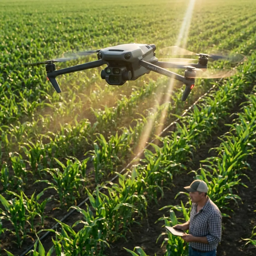
For pilots using the Mavic 4 Pro in vineyards, especially in hilly terrain, the real challenge is not simply getting imagery. It is getting imagery that is consistent enough to be useful while keeping the aircraft safe around wires, trellis systems, tree lines, and elevation changes. If you are documenting vine vigor, seasonal change, drainage patterns, or the visual character of a property, the Mavic 4 Pro’s value comes from how its flight intelligence, camera controls, and obstacle awareness come together in actual field conditions.
I approach this as a photographer first, but vineyard work rewards a mapping mindset. You are not just creating attractive footage. You are building a visual record that needs to hold up over time.
The vineyard problem: steep ground changes everything
Flat farmland forgives mistakes. Vineyards in complex terrain do not.
Rows bend with the hillside. Access routes cut across contours. Wind behaves differently at the top of a ridge than it does near a sheltered lower block. A route that looks clean from takeoff can become risky once the aircraft crosses a rise and the surrounding trees suddenly sit much closer to the flight path than expected. Add low-angle morning light or late-afternoon haze, and even experienced pilots can find themselves working harder than they should.
This is exactly why obstacle avoidance matters so much in vineyard operations. Not as a marketing bullet. As operational insurance.
On a Mavic 4 Pro, obstacle sensing and route awareness help when the aircraft is moving between vineyard parcels, skimming along irregular boundaries, or transitioning from open rows to tighter terrain near roads and woodland edges. In mapping terms, that means fewer interruptions and more confidence in maintaining a repeatable flight path. In visual survey work, it means you can concentrate more on framing, overlap, and exposure consistency instead of constantly second-guessing every approach.
Still, the safety stack only works if you treat it properly.
The pre-flight step many pilots rush past
Before any vineyard mission, I recommend a simple ritual: clean the vision sensors and camera glass before powering up and again just before launch if dust is blowing.
That sounds minor until you work in agricultural environments regularly. Vineyards generate fine dust on access roads, pollen in season, and occasional spray residue in surrounding operational areas. Even a thin film on obstacle sensing elements can reduce the reliability of safety features precisely when you are threading a route near trellis ends, isolated trees, or elevation breaks.
This pre-flight cleaning step matters because obstacle avoidance is only as trustworthy as the sensors feeding it. If you rely on automated safety support, ActiveTrack, or any intelligent flight mode in tight terrain, clear sensors are not optional. They are part of the mission setup.
For the same reason, I also check for smudges on the lens before flights intended for orthographic capture, time-series documentation, or deliverables for owners and agronomy teams. A tiny haze patch may not ruin casual footage, but it can flatten contrast and reduce the clarity you need when comparing canopy development across dates.
Why biodiversity awareness belongs in a vineyard drone workflow
There is another layer to flying responsibly in rural landscapes: understanding that cultivated land often sits beside ecologically sensitive habitat.
A recent wildlife report from Shennongjia in Hubei described the region as a “species gene bank,” home to many ancient species, including the Sichuan golden snub-nosed monkey. That animal was first documented there by a scientific expedition in 1977. Under strict protection, the local population grew from just over 500 in 1990 to 1,473 in the latest count.
Those numbers are not just inspiring conservation news. They are a useful reminder for commercial drone pilots.
Why? Because mapping work rarely happens in isolation. Vineyards can border forest margins, watercourses, and habitat corridors. The lesson from Shennongjia is that protected landscapes can recover when human activity becomes more disciplined. For a vineyard drone operator, that translates into practical choices: avoid unnecessary low passes near adjacent woodland, keep launch zones clear of wildlife movement, and favor efficient flight plans over repeated manual scouting loops. If a region can protect a visually striking primate population over decades, moving from around 500 individuals to 1,473, we can certainly design our UAV workflows to reduce disturbance while still getting excellent agricultural data.
That connection matters even more if your vineyard property is marketed around terroir, sustainability, or landscape stewardship. The drone should help document that relationship, not disrupt it.
The solution: use the Mavic 4 Pro as a dual-purpose aircraft
The strongest vineyard workflow with the Mavic 4 Pro is not purely cinematic and not purely technical. It is both.
One flight block may be designed for structured mapping: stable altitude, deliberate overlap, consistent speed, and clean coverage across rows despite changing terrain. Another may be built for observational visuals: oblique passes, boundary inspections, slope drainage review, and story-driven clips that show how the vineyard sits in the land.
This is where the aircraft’s feature set becomes genuinely useful.
Obstacle avoidance for terrain transitions
When a block drops away sharply or rises toward a ridge, obstacle awareness helps the aircraft manage transitions with less pilot workload. That is especially useful in vineyards where a row-end turnaround may place the drone closer to posts, trees, or utility features than it appeared from the original angle.
Operationally, the significance is simple: more consistent missions and fewer aborted runs. In complex terrain, every restart introduces variation. Variation weakens comparison data and wastes battery time.
ActiveTrack and subject tracking for moving field operations
Subject tracking is not only for action footage. In a vineyard context, ActiveTrack can be useful when documenting moving utility vehicles, scouting teams, or guided estate tours along designated internal roads. If you are producing visual updates for management, hospitality teams, or seasonal operations, tracking can keep a subject framed while you maintain broader awareness of the environment.
The operational value here is efficiency. Instead of manually correcting every framing drift while also monitoring terrain, the tracking system can handle part of the visual task. That frees mental bandwidth for flight safety and route judgment.
Of course, I would not use tracking indiscriminately in cluttered zones without first checking sensor cleanliness and confirming a safe corridor. Intelligent features are assistants, not substitutes for pilot discipline.
QuickShots and Hyperlapse for repeatable seasonal storytelling
A vineyard is a place of change. Bud break, canopy expansion, veraison, harvest, pruning season—each phase reshapes the geometry and color of the site. QuickShots and Hyperlapse become useful when that change needs to be shown clearly over time, not just beautifully in a single clip.
Hyperlapse is particularly strong for demonstrating shifting light over ridgelines, fog movement across blocks, or the pace of activity during harvest windows. The point is not novelty. It is interpretation. Timed visuals can reveal terrain influence, drainage behavior, and exposure differences between parcels in a way static maps do not.
QuickShots, used carefully, can also create standardized visual assets for recurring property updates. If you repeat a similar movement at set intervals through the season, you build a visual archive that is easier to compare.
D-Log for vineyards with punishing contrast
Complex terrain often means difficult light. One side of a block catches harsh sun while the next row falls into deep shadow from a hill or adjacent tree line. Standard profiles can clip bright highlights or bury subtle detail in darker foliage. D-Log helps preserve more tonal flexibility, which matters if your final output includes slope analysis visuals, polished stakeholder reports, or branded estate films.
The practical significance is not abstract color science. It is the ability to hold detail across sunlit soil, green canopy, reflective leaves, and shaded understory in the same scene. When you are showing the health and structure of a vineyard, those tonal differences carry information.
Building a reliable vineyard mission plan
A good Mavic 4 Pro workflow for this kind of site usually follows a simple logic.
Start with a reconnaissance pass at a conservative altitude. Not to gather final deliverables, but to verify wind behavior, identify obstacles hidden by slope angle, and confirm whether row orientation changes enough to affect your intended flight lines.
Then move into your mapping or documentation pass with a clear priority. If the mission is agronomic or planning-focused, consistency comes first. Hold speed, spacing, and camera settings as steady as possible. If the mission is estate storytelling or client reporting, create a shortlist of must-have perspectives before launch so you are not improvising unnecessary maneuvers over uneven ground.
Before every battery swap, do a fast sensor and lens check. Dust accumulation can build quicker than many pilots expect, especially from gravel roads and dry headlands. Again, that one habit protects both obstacle sensing reliability and image quality.
Human judgment still matters most
The Mavic 4 Pro can make complex flights feel simpler, but vineyards punish overconfidence.
Obstacle avoidance can help you avoid obvious trouble. It cannot know your deliverable standards. Subject tracking can maintain framing. It cannot decide whether a route is respectful of neighboring habitat. D-Log can preserve dynamic range. It cannot fix a rushed mission flown in bad light at the wrong altitude.
This is why I like the Shennongjia wildlife story as a frame for drone work, even though the subject there is completely different. A region known for rare biodiversity, where a species first documented in 1977 has grown under careful protection from roughly 500 animals in 1990 to 1,473 today, proves that measured stewardship works. Vineyard drone operations benefit from the same mindset: observe first, plan carefully, interfere less, collect better data.
That mindset also leads to better imagery. The best vineyard footage usually comes from patience, not aggressive flying.
A practical field checklist for Mavic 4 Pro vineyard work
If I were packing for a day of mapping vineyards in broken terrain, my priorities would be these:
- Clean all obstacle sensing surfaces before startup
- Recheck the lens for haze, fingerprints, or dust before launch
- Fly an initial reconnaissance pass to assess slope-related obstacle proximity
- Use obstacle avoidance actively when transitioning between blocks or near boundary vegetation
- Reserve ActiveTrack for predictable, low-risk movement paths such as internal roads or support vehicles
- Capture key repeatable seasonal angles with QuickShots or structured manual moves
- Use Hyperlapse when terrain, fog, light shift, or harvest activity needs temporal context
- Shoot in D-Log when contrast is severe and the footage needs grading latitude
- Minimize unnecessary low flights near adjacent habitat or wooded margins
If you need to talk through a vineyard workflow, terrain strategy, or camera setup before your next mission, you can reach out directly on WhatsApp for a practical field discussion.
The bigger point
The Mavic 4 Pro is most valuable in vineyards when it is treated as a precision observation platform, not just a camera in the sky. In complex terrain, that distinction matters. You are balancing safety systems, image discipline, environmental awareness, and repeatability.
Get the basics right, especially the unglamorous ones like sensor cleaning and route planning, and the advanced features start to pay off. Ignore those basics, and even a capable aircraft becomes inconsistent.
For vineyard teams, consultants, and visual storytellers, the goal is not simply to fly successfully. It is to return with data and imagery that mean something next week, next season, and next year.
Ready for your own Mavic 4 Pro? Contact our team for expert consultation.