Mavic 4 Pro Field Report: Mapping Remote Vineyards When
Mavic 4 Pro Field Report: Mapping Remote Vineyards When the Weather Turns
META: A field-tested look at using the Mavic 4 Pro for remote vineyard mapping, with practical insight on obstacle avoidance, ActiveTrack, D-Log, Hyperlapse, and changing mid-flight weather.
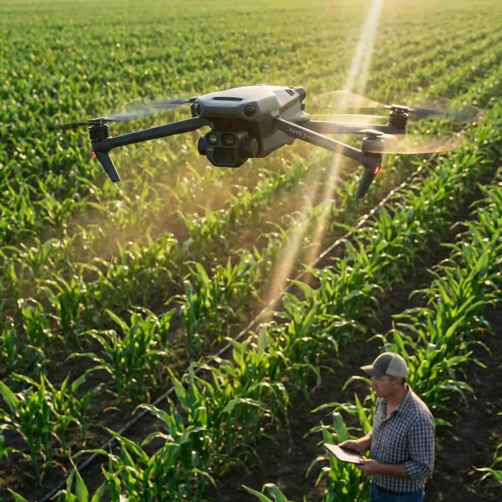
I took the Mavic 4 Pro into vineyard country for a job that sounds straightforward until you are standing on a slope with shifting wind, patchy signal conditions, and rows of vines that all look identical from 80 meters up. The assignment was to map a remote vineyard block, capture usable visual records for the grower, and leave with footage that could support both operational review and future promotional edits.
That mix matters. A drone can be excellent at collecting pretty footage and still be frustrating for field documentation. Vineyard work exposes that quickly. You need repeatable flight paths, stable image capture across uneven terrain, and enough situational awareness to work around trellis wires, tree lines, and sudden weather changes. On this flight, the weather changed halfway through. The light flattened, the wind stiffened, and a calm mapping session turned into a real test of how the aircraft handled decision-making under pressure.
The Mavic 4 Pro felt less like a camera in the sky and more like a field tool built for jobs where the plan never survives first contact with the landscape.
Why vineyard mapping is harder than it looks
Remote vineyard blocks create a strange combination of order and risk. On the ground, the rows are tidy and deliberate. In the air, that repeating geometry can make it difficult to maintain orientation, especially when the terrain rolls or the vines are broken up by access roads and shelterbelts. Add changing weather and the margins get tighter.
This is where obstacle avoidance stops being a marketing bullet and becomes operationally relevant. In vineyard environments, hazards are not always dramatic. The real problem is the quiet stuff: isolated cypress lines at the property edge, utility poles near sheds, elevated netting, and abrupt rises in the land that shorten your vertical buffer without warning. When wind pushes the aircraft off line, those details matter more than headline flight specs.
On this job, I was not weaving aggressively through rows. That is not the point of a mapping-focused session. But I was moving laterally across irregular boundaries and descending for lower-angle reference passes. The Mavic 4 Pro’s obstacle sensing provided the kind of confidence that lets you stay focused on coverage and framing instead of constantly second-guessing every proximity decision. In a remote setting, where a recovery walk can cost time and daylight, avoiding one bad branch strike is worth far more than an extra cinematic trick.
The mid-flight weather shift changed the mission
The first part of the flight was ideal. Early light gave the vines texture, and I was collecting broad overhead passes to define row spacing, drainage flow, and the relationship between vine blocks and surrounding access tracks. Then the weather swung.
The wind arrived first, not violently, but enough to turn smooth passes into corrective flying. A few minutes later the light changed too. What had been clean directional illumination became a flatter, more muted scene. That may sound like a creative nuisance, but for mapping and visual inspection it creates a practical problem. Inconsistent light can hide canopy differences, soften ground contrast, and reduce the clarity of edge features that help a grower interpret what they are seeing.
This was the point where the Mavic 4 Pro earned its keep. Stable positioning in gustier conditions is one thing. What stood out more was how manageable the aircraft remained when the mission objective had to shift from ideal capture to resilient capture. I shortened my passes, tightened the working area, and prioritized the blocks most exposed to wind. That sort of adaptation only works if the drone still feels predictable. The Mavic 4 Pro did.
I also changed my capture strategy. Rather than forcing one long sequence, I broke the work into shorter, more controlled segments. A field operator knows this instinctively: when conditions become less cooperative, reduce complexity. The aircraft’s control responsiveness and situational feedback supported that decision instead of fighting it.
D-Log proved useful for more than “cinematic” reasons
A lot of pilots hear D-Log and think only about color grading. That is too narrow, especially in agricultural work. Yes, a flatter profile gives you more room in post. But on a day when the sun ducks behind cloud cover halfway through a mission, that flexibility stops being stylistic and starts being practical.
The Mavic 4 Pro’s D-Log option made it easier to preserve consistency across footage captured under two different lighting conditions. For a vineyard owner or manager reviewing rows, access routes, and canopy variation, continuity matters. If one set of clips is punchy and contrast-heavy while the next is dull and compressed, subtle field differences become harder to interpret. A more controllable profile helps you normalize those shifts later.
That does not mean every vineyard mapping job should be treated like a film grade. It means the aircraft gives you a margin for correction when the environment refuses to cooperate. In this case, that margin mattered. The footage from before and after the weather change could be brought closer together without forcing the image.
For photographers moving into applied drone work, this is one of the more underrated benefits of a professional-grade imaging workflow. You are not just capturing beautiful visuals. You are preserving useful information under inconsistent field conditions.
ActiveTrack and subject tracking have a place here, but not in the obvious way
When people think about ActiveTrack or subject tracking, they usually imagine athletes, vehicles, or travel footage. Vineyards sound static by comparison. Yet those tools can still be valuable on site, particularly when documenting movement through the property rather than just the property itself.
I used tracking during a short utility sequence involving a vineyard vehicle moving along the central access road. That footage was not the core of the mapping mission, but it added context. Aerial mapping tells you how the site is laid out. Tracking a moving vehicle through that layout shows scale, surface condition, turn access, and how the operational spine of the property actually functions. For remote blocks where logistics matter, that context is useful.
The significance is not the automation itself. The significance is that the Mavic 4 Pro can pivot from structured documentation to supporting footage without changing aircraft or workflow. In real field assignments, that flexibility saves time. If the grower wants both survey-style overheads and a few dynamic clips for internal presentations, you can capture both in one session.
I would still be conservative with automated modes in dense agricultural environments. Trellis systems, edge trees, and gusty wind are not a place to get complacent. But used selectively and with clear airspace, ActiveTrack can help tell the operational story of a vineyard rather than just its geometry.
QuickShots and Hyperlapse are not fluff if you use them correctly
I am usually skeptical of automated creative modes on practical jobs. Too often they distract from the task. But QuickShots and Hyperlapse can be smart additions when the client needs communication assets beyond raw mapping footage.
A Hyperlapse sequence over a vineyard block can reveal cloud movement, shadow travel, and the way terrain interacts with light across the property. That is not merely attractive. It can help explain exposure differences between rows or illustrate why one section dries faster than another after weather changes. In a remote vineyard, where microclimate affects decision-making, time-compressed visual context can be surprisingly useful.
QuickShots are more situational. I would not rely on them for core inspection or mapping outputs. But if you need a concise establishing shot for a report intro, project recap, or grower update, they can produce a clean result quickly. The key is not to confuse convenience with coverage. Automated creative shots are supplements, not substitutes.
That distinction matters because too many drone operators let feature lists dictate the mission. In vineyard work, the mission dictates the feature list.
Remote work exposes the difference between a smart drone and a merely capable one
Anyone can fly a drone over vines on a calm day near a road. Remote vineyards raise the stakes. Travel time is longer. Conditions are harder to predict. The cost of a mistake is higher because support is farther away and the shooting window may not come back soon.
That is where the Mavic 4 Pro makes sense for this kind of assignment. The combination of obstacle avoidance, reliable subject tracking tools, flexible capture modes, and D-Log workflow creates a drone that adapts when the field does not. No single feature solves vineyard mapping on its own. The value comes from how those features interact under pressure.
For example, obstacle sensing lowers mental load when you are repositioning near tree lines. D-Log protects image continuity when the sky changes ten minutes earlier than the forecast suggested. ActiveTrack helps document movement patterns on the property without requiring a fully manual chase shot. Hyperlapse adds temporal context that static maps cannot show. Each tool is familiar on paper. In the field, the benefit is cumulative.
During this session, that cumulative benefit showed up in a simple way: I completed the essential capture list even after the weather changed, and I came back with more than one type of usable asset. That is the benchmark I care about.
What I would do differently on the next vineyard run
The weather shift reinforced a few habits that are worth sharing if you are planning similar work with the Mavic 4 Pro.
First, capture your most mission-critical overhead passes early, even if the light is beautiful and you are tempted to chase the dramatic angles. In agricultural work, conditions can turn in minutes. Get the non-negotiables first.
Second, separate your flights mentally into layers: mapping, inspection, and storytelling. Mapping footage answers layout questions. Inspection footage focuses on detail and anomalies. Storytelling footage helps the client communicate value or context to others. The Mavic 4 Pro can cover all three, but only if you decide which one you are shooting at any given moment.
Third, treat automated features as assistants, not decision-makers. Obstacle avoidance is valuable. ActiveTrack is useful. QuickShots can save time. None of them replace site judgment, especially around wires, wind, or uneven topography.
And finally, build a communication rhythm with the client before takeoff. On remote agricultural jobs, clarity saves battery cycles. Know whether they care most about canopy uniformity, access roads, drainage, perimeter condition, or presentation visuals. If you want to compare notes on field workflows, I’ve found that a quick message exchange can solve more than a long gear debate—reach me here: https://wa.me/example
The broader takeaway for Mavic 4 Pro pilots
The Mavic 4 Pro is at its best when the assignment sits between technical documentation and visual storytelling. Vineyard mapping in remote conditions is exactly that kind of work. You need stable flight behavior, dependable obstacle awareness, adaptable image capture, and enough creative headroom to produce assets that serve more than one purpose.
This field session did not prove that technology eliminates weather risk. It proved something more useful: the right drone reduces how much the environment can derail your plan. That is a meaningful distinction. Mid-flight weather changes will still force choices. Gusts will still eat into confidence. Flat light will still challenge contrast. But with the Mavic 4 Pro, those problems feel manageable instead of mission-ending.
For photographers stepping into agricultural operations, that matters. For growers commissioning drone work in hard-to-reach locations, it matters even more. They are not buying a spectacle. They are asking for reliable perspective.
On this vineyard job, the Mavic 4 Pro delivered exactly that. Not perfection. Something better: control, flexibility, and enough resilience to keep working when the day stopped being easy.
Ready for your own Mavic 4 Pro? Contact our team for expert consultation.