How I’d Use the Mavic 4 Pro to Map Solar Farms in Low Light
How I’d Use the Mavic 4 Pro to Map Solar Farms in Low Light
META: A practical Mavic 4 Pro workflow for low-light solar farm mapping, focused on optical payload behavior, pre-flight sensor cleaning, obstacle avoidance, and image capture discipline.
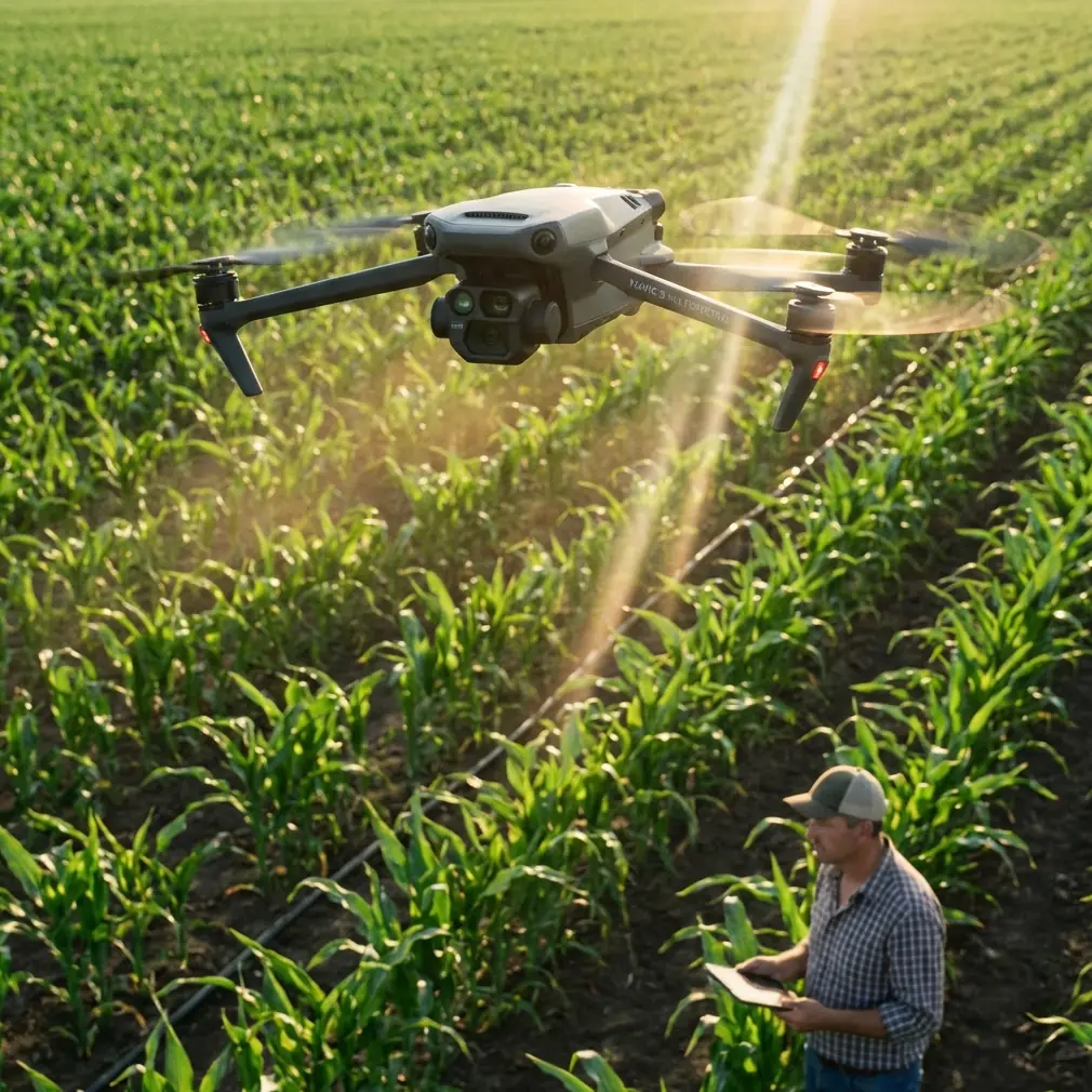
Solar farms look simple from the road. Long rows. Repeating geometry. Wide access lanes. Once you’re in the field before sunrise or near the end of the day, that simplicity disappears.
Low-angle light creates deep contrast across panel rows. Dew, dust, and reflective glass fight your camera. Perimeter fencing, combiner boxes, weather masts, and cable runs complicate flight paths. If your goal is usable mapping data rather than pretty footage, every decision starts with the payload.
That is the right place to think about the Mavic 4 Pro.
Not because of marketing claims, but because the core logic of drone sensing still applies: the airborne payload is dictated by aircraft size, carrying capacity, and the job itself. That principle matters a lot when mapping solar assets in low light. A compact platform can be highly effective, but only if you build the mission around what optical systems do well and where they need help.
Start with the real advantage: optical payloads are precise and intuitive
For low-light solar farm work, the most relevant insight from traditional UAV payload theory is that electro-optical systems offer very high angular measurement precision. The reference material puts optical angle measurement in the milliradian range, while radar commonly sits at the degree scale. For a field operator, that difference is not academic.
It translates into cleaner visual discrimination when you are trying to follow row alignment, identify panel-table boundaries, and maintain confidence over repetitive geometry in dim conditions. Solar sites are full of patterns that can trick the eye. A camera-based workflow gives you immediate visual confirmation of what the aircraft is actually seeing, which is far more useful in day-to-day civilian inspection and mapping than abstract sensor returns.
That direct image display is another major strength. Optical payloads show geometric or thermal imagery in a form pilots and analysts can interpret quickly. On a solar farm at first light, that matters because delays compound. If you need to pause and confirm whether a dark band is a shadow line, a drainage strip, or a row gap, a visually legible live view saves time and prevents bad data collection.
The reference also notes that optical payloads tend to be lighter, more compact, and modular compared with radar systems. On a smaller aircraft class, that matters operationally. A lighter sensing package supports practical deployment, faster setup, simpler maintenance, and fewer field headaches. For a pilot walking a large site perimeter before dawn, reduced complexity is not a luxury. It is what keeps the mission moving.
Why low light changes the mapping plan
Most solar farm flights happen under narrow timing windows. Sometimes you want softer light to reduce harsh reflections. Sometimes you are documenting site conditions before crews arrive. Sometimes ambient heat later in the day will complicate thermal interpretation, even if your primary deliverable is still visual mapping.
Low light sounds gentle, but it is demanding. Obstacle sensors can be less confident. Surface contrast drops. Access roads and inverter pads may remain visible while row interiors sink into shadow. Subject separation gets weaker, and repetitive panel lines can confuse automated behavior if your route planning is sloppy.
This is why I would not treat the Mavic 4 Pro as a “launch and trust automation” aircraft on this job. I would treat it as a camera platform with smart safety systems that need ideal input.
And that begins with one very unglamorous step.
The pre-flight cleaning step I never skip
Before any low-light mission over a solar site, I clean every vision-related surface on the aircraft.
Not just the main lens. The obstacle sensing windows too.
Dust, pollen, dried moisture, and oily smudges reduce the quality of the visual data feeding obstacle avoidance. In marginal light, even a small loss in contrast can make a smart aircraft less smart. Solar farms are notorious for fine dust. Add dew at sunrise, and you have exactly the kind of contamination that degrades safety features without being obvious from a quick glance.
My sequence is simple:
- Inspect the primary camera glass under a flashlight.
- Wipe obstacle sensing lenses with a clean microfiber.
- Check for moisture residue around the gimbal housing.
- Confirm no streaking remains.
- Power on and verify the live view is clean before takeoff.
This is not about cosmetic perfection. It is about feeding the aircraft the best possible visual information when the environment is already reducing it.
If you rely on obstacle avoidance near service roads, fence lines, tracker mechanisms, or weather instrumentation, dirty sensing windows can quietly increase risk. The same goes for ActiveTrack-style functions and any subject tracking behavior. Even if you only use tracking sparingly on an industrial site, low-light performance improves when the sensors are physically clean.
Build the mission around image consistency, not cinematic temptation
The Mavic 4 Pro conversation often drifts toward creative features like QuickShots, Hyperlapse, and dramatic reveal shots. Those features have their place for stakeholder updates and marketing documentation, but they are secondary here.
For solar farm mapping, consistency wins.
You want repeatable altitude, overlap discipline, steady speed, and exposure choices that preserve panel detail without crushing shadows between rows. If I were shooting a low-light mapping pass, I would prioritize manual control and predictable geometry over any automated cinematic mode. QuickShots might look polished, but they do not solve the data problem. Hyperlapse is visually interesting, yet it is not the backbone of a mapping workflow.
That said, these tools are not useless.
A short Hyperlapse sequence from a safe standoff point can be valuable for showing how shadow progression moves across an array over time. QuickShots can also help produce a brief visual context package for asset managers who need orientation before reviewing the main mapping outputs. The key is to keep them separate from the core survey mission. Data first. Presentation second.
Obstacle avoidance is useful, but row geometry can trick you
Solar farms are strange environments for avoidance systems. They combine open airspace with dense repeated structures. That can create overconfidence in pilots.
A Mavic-class drone may have excellent obstacle awareness in general use, but low light plus reflective panel surfaces can make perception less straightforward than the spec sheet suggests. Panel rows often produce repeating lines, narrow visual corridors, and glare transitions that challenge visual interpretation. Add fences, parked maintenance vehicles, and isolated poles, and you have a site that rewards conservative routing.
My rule is simple: obstacle avoidance is a backstop, not the flight plan.
I would avoid threading tight spaces between rows unless the mission absolutely requires it. For broad mapping coverage, higher and cleaner flight lines are usually the better choice. You reduce collision risk, improve consistency, and avoid asking the aircraft to solve edge cases in dim conditions.
If I need lower-altitude contextual shots of damaged rows, I slow down, widen margins, and stop treating the site like a creative playground. Industrial work benefits from boring habits.
Low-light tracking: when ActiveTrack helps and when it doesn’t
ActiveTrack and similar subject tracking tools can be useful on a solar farm, but not for everything.
If you’re documenting a maintenance vehicle route, tracking a walking inspector for training content, or capturing a repeatable handoff sequence between field teams and the drone operator, automated subject tracking can save workload. In these cases, the aircraft’s ability to maintain framing lets you focus on spacing, altitude, and obstacle awareness.
But I would not use tracking as a substitute for mapping discipline. Rows of panels are not “subjects” in the same way a person or vehicle is. The aircraft may maintain visual lock on a moving object while the broader mission geometry drifts away from what your map requires.
In low light, this distinction matters even more. Tracking can support operational storytelling or training clips. It should not define the core survey path.
Color profile choices matter, especially if you’re delivering analysis-ready visuals
A lot of pilots switch to flat profiles such as D-Log by reflex. Sometimes that is the right call. Sometimes it only creates extra work.
For solar farm mapping in low light, the question is not whether D-Log is “better.” The question is whether your downstream process benefits from the extra grading latitude. If the deliverable includes stakeholder visuals, inspection summaries, or blended media outputs, D-Log can help preserve highlight and shadow detail across reflective panel surfaces and dark access zones.
That flexibility can be useful at dawn or dusk, when bright sky values and dark ground elements push the image in opposite directions.
But if the mission demands fast turnaround and standardized output, I would rather have disciplined exposure and a consistent workflow than a flat profile used carelessly. D-Log is a tool, not a badge of seriousness.
What the reference sensor data tells us about mission design
One overlooked detail in the source material is the distribution of common optical sensors across UAV types. Daylight TV cameras appear at 79% in one category and 100% in another, while infrared camera or forward-looking infrared appears at 72% in one category but much lower elsewhere. That tells us something practical: visible-spectrum imaging remains the baseline payload logic for many UAV tasks, while infrared capability is highly mission-dependent rather than universal.
For a solar farm operator, that is a useful framing device.
It means you should not assume every low-light problem is solved by chasing specialized sensing. Often, the visible camera is still the foundation of the workflow. Mission timing, light management, route design, and image discipline may improve output more than simply wishing for a different sensor stack.
The second operational takeaway is payload choice must fit aircraft size and task need. That sounds obvious, but it prevents poor planning. A compact aircraft like the Mavic 4 Pro is attractive because it is deployable and efficient. That same compactness means your workflow has to respect what the platform is optimized to do well: agile optical imaging with practical field mobility, not every possible sensing job at once.
A field workflow I’d actually use
If I were mapping a solar site in low light with the Mavic 4 Pro, my sequence would look like this:
1. Walk the launch area before power-on
I want to see dust level, moisture on surfaces, vehicle traffic, and any temporary hazards such as open gates or stacked materials.
2. Clean the camera and obstacle sensors
This is the step many pilots rush. On a dusty site, it is one of the most valuable things you can do for both image quality and obstacle avoidance reliability.
3. Confirm mission priority
Is this a map, a visual inspection set, a progress record, or a stakeholder overview? One flight cannot be optimized equally for all four.
4. Fly the mapping mission first
Use the best available ambient stability window. Do not burn battery on cinematic clips before the core capture is complete.
5. Keep spacing conservative
Repeated panel geometry and dim light are not the time to push low-clearance passes unless there is a specific inspection reason.
6. Use tracking and creative modes only after the core work
ActiveTrack, QuickShots, and Hyperlapse can support training, reporting, or presentation. They should not compromise the primary data run.
7. Review images on site
Because optical imagery is direct and intuitive, you can catch row gaps, exposure issues, or alignment errors immediately rather than discovering them back at the office.
If you need help planning that kind of workflow for a specific site layout, I’d suggest sharing the mission brief through this field support chat.
The practical case for the Mavic 4 Pro here
The Mavic 4 Pro makes sense for low-light solar farm mapping when you use it within the logic of optical payloads.
Its value is not abstract. It sits in three practical areas.
First, optical sensing gives you highly usable visual information. The reference’s comparison between milliradian optical precision and degree-level radar precision explains why image-based work remains so strong for structural interpretation and alignment-sensitive tasks.
Second, compact optical payloads are lighter and simpler. On a commercial site, that means easier transport, faster setup, and less field friction.
Third, direct image display supports immediate decisions. On a low-light solar mission, seeing the scene clearly and intuitively is often what separates a clean job from a compromised one.
That does not eliminate limitations. Low light still narrows margins. Obstacle avoidance still depends on clean sensor surfaces and realistic routing. Tracking tools still need supervision. Flat color profiles still require intent.
But if you respect those realities, the aircraft becomes far more useful than a generic “smart drone” label suggests. It becomes a disciplined optical platform for a very specific kind of fieldwork.
And that is exactly how I would approach mapping solar farms with it.
Ready for your own Mavic 4 Pro? Contact our team for expert consultation.