Mavic 4 Pro for Urban Highway Mapping: What a Counter
Mavic 4 Pro for Urban Highway Mapping: What a Counter-Drone Production Surge Really Signals for Civil Drone Operators
META: A field-focused analysis of what Alpine Eagle’s Sentinel production expansion means for Mavic 4 Pro pilots mapping urban highways, with practical insight on safety, airspace pressure, and mid-flight weather handling.
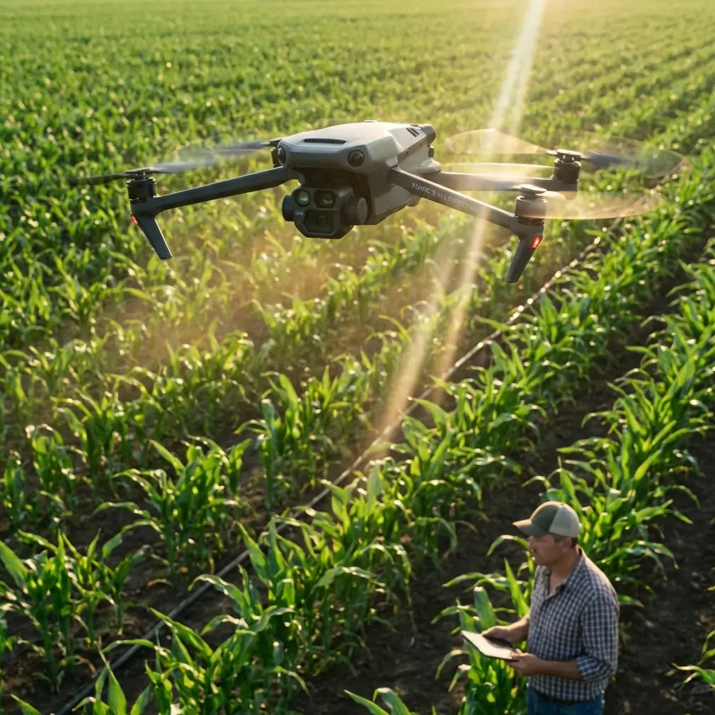
Urban highway mapping rarely feels dramatic when you are the one behind the sticks. Most days, it is methodical work: traffic rhythm, lane geometry, bridge transitions, glare off glass towers, wind tunneling between buildings, and the constant requirement to gather clean, repeatable data without causing friction in already busy airspace.
That is exactly why a seemingly defense-centered headline matters to civilian operators flying a Mavic 4 Pro.
On March 19, 2026, DroneLife reported that Alpine Eagle, a European counter-drone company, is scaling production of its Sentinel system as demand rises across defense markets. Two details stand out immediately. First, this is not a laboratory concept getting press attention; it is a production expansion. Second, the stated driver is the need for fast, deployable, cost-effective air defense tools.
If you map highways in urban environments, those details are not abstract. They point to a near-future operating environment where more drone-detection and drone-response systems will be active around public infrastructure, government corridors, logistics nodes, and transport networks. A highway survey mission with a Mavic 4 Pro can still be entirely lawful, professionally planned, and technically sound. But the surrounding ecosystem is changing. Fast.
Why a Counter-Drone Factory Story Matters to a Mavic 4 Pro Pilot
A lot of drone articles make the mistake of separating “defense drone news” from “commercial drone operations,” as if the two worlds never touch. That line has been fading for years. Urban infrastructure is exactly where they start to overlap.
Highways pass near sensitive buildings, rail interchanges, utility corridors, distribution centers, and temporary security perimeters. When a company like Alpine Eagle expands output of a system such as Sentinel, it suggests that more organizations expect real operational need, not occasional experimentation. The phrase “deployable” is especially telling. Fixed installations are one thing. Systems that can be moved and set up quickly are different. They create a more dynamic airspace picture for pilots conducting corridor mapping.
For a Mavic 4 Pro operator, the operational significance is straightforward: your mission planning now has to assume that detection capability may appear in places where it was absent a year earlier. That does not mean your aircraft becomes unusable. It means the burden on documentation, coordination, and flight discipline rises.
This is where the Mavic 4 Pro’s value becomes clearer. In urban highway work, you need a platform that can gather precise visuals efficiently, adapt to interruptions, and stay predictable when conditions shift. Not glamorous. Just reliable.
The Real Problem in Urban Highway Mapping
Mapping highways in a city is rarely limited by raw image quality alone. The harder problem is consistency under pressure.
You are often dealing with:
- constrained launch points,
- interrupted sightlines,
- reflective surfaces,
- uneven GPS behavior near structures,
- wind shear between buildings and overpasses,
- and narrow windows for safe, low-disruption flight.
Add the broader trend implied by the Sentinel news, and one more problem enters the picture: scrutiny. As counter-drone systems become more common, operators who fly without a clear paper trail or sloppy on-site communication will draw attention quickly. That is especially true near transportation infrastructure.
I have seen this play out in a very practical way. A route that looked simple on a map became complicated once a weather shift rolled in mid-flight. What began as a stable urban mapping run turned into a test of discipline. Wind changed direction along an elevated section, light flattened, and the air got more turbulent near a concrete sound barrier. This is the sort of moment where flashy specs stop mattering and flight behavior matters a lot.
The Mavic 4 Pro handled that transition the way a serious field tool should. Obstacle avoidance did not solve the weather, of course, but it reduced workload when repositioning around sign gantries and lighting poles during the return leg. ActiveTrack and subject-oriented features like subject tracking are often discussed in cinematic contexts, but the deeper value is processing confidence in complex scenes. Even when you are not “tracking” a moving subject for a promo shot, the aircraft’s scene awareness helps maintain composure in busy environments.
That composure is worth more than people think when the mission objective is mapping a highway corridor before the weather closes your margin.
The Solution Is Not Just Better Flying. It Is Better Mission Design.
The Alpine Eagle story points to a broad truth: the age of casual infrastructure flying is ending. Counter-drone expansion across Europe reflects a larger security posture, and urban operators should read that correctly. The answer is not fear. The answer is structured professionalism.
A Mavic 4 Pro is well suited to this if you use it as a mapping platform first and a content machine second.
For urban highway work, the best workflow starts before takeoff:
- Define the corridor and all adjacent sensitive zones, not just the road itself.
- Assume temporary security systems may be present even if they are not visible.
- Keep flight profiles efficient and repeatable.
- Prioritize clean passes over unnecessary airtime.
- Prepare a weather contingency that includes a shortened capture pattern.
The mention in the news that governments want “fast, deployable” systems matters because it tells us the operating environment can change quickly. A pilot who planned around last month’s conditions may be planning for the wrong airspace culture. That is why pre-briefing matters so much. If your mapping team is coordinating with stakeholders, site managers, or traffic-related authorities, having a clean explanation of your route, altitude logic, and timing can prevent confusion before it starts. If you need a simple direct channel for coordination, I usually recommend setting one up in advance, even something as lightweight as a field contact line for the day of operations.
That kind of preparation is not bureaucracy for its own sake. It is what separates smooth urban missions from avoidable interruptions.
Where the Mavic 4 Pro Fits in This New Reality
The Mavic 4 Pro’s advantage in highway mapping is not that it somehow neutralizes tighter airspace awareness around infrastructure. No drone does that. Its advantage is that it helps you finish demanding visual tasks efficiently enough to reduce exposure.
That shows up in several ways.
Obstacle avoidance becomes more than a convenience in dense road environments. It supports safer repositioning near overpasses, poles, utility structures, and elevated signage. If the weather changes mid-flight, as it often does in city corridors, that margin matters. A gust that pushes the aircraft off the clean line you wanted is annoying. A gust that pushes it toward roadside structures is a safety problem.
D-Log also has practical mapping value when conditions turn ugly. In urban highway scenes, reflective surfaces and patchy contrast can wreck consistency from one pass to the next. If clouds move in halfway through a job, flatter capture options can preserve more usable tonal information for later review, annotation, or integration into broader project visuals. People often pigeonhole D-Log as something only filmmakers care about. For infrastructure documentation, it can help stabilize output quality when the sky refuses to cooperate.
QuickShots and Hyperlapse are not the core tools for strict mapping deliverables, but they do have secondary value. On some projects, stakeholders want a contextual visual of traffic flow, interchange complexity, or the relationship between road geometry and surrounding development. Those modes can supplement the primary mapping mission without requiring a second platform. The key is discipline: use them as supporting tools, not replacements for structured capture.
Weather Changed Mid-Flight. Here Is What Actually Helped.
On the highway run I mentioned earlier, the change started subtly. The wind was not violent. It was inconsistent, which is worse in a city. One section of roadway was calm. The next, near an elevated merge, produced lateral drift and visible instability in the trees along the edge barrier. Then the light changed. Hard contrast gave way to a flatter, dimmer scene that reduced the visual punch of lane markings and surface texture.
This is where the Mavic 4 Pro earned its keep.
First, stable control response made it possible to shorten the route without turning the return into a scramble. Second, obstacle avoidance reduced the mental load when backing away from a tighter roadside segment. Third, the camera workflow remained flexible enough to preserve usable footage after the lighting changed. The result was not perfect continuity, but it was operationally successful: the mission came home safely with enough clean material to complete the analysis.
That matters because urban highway mapping is not judged on how cinematic it looked in perfect weather. It is judged on whether the data remains usable when conditions stop cooperating.
The Bigger Industry Shift Behind This Story
Alpine Eagle scaling Sentinel production is one of those news items that looks niche until you consider the timing and wording. Rising defense demand is one thing. Rising demand for cost-effective, deployable systems is broader. That points toward normalization. As detection and response tools become easier to field, more public and semi-public spaces may sit under some level of observation for drone activity.
For Mavic 4 Pro operators, especially those working in infrastructure-adjacent environments, this changes the meaning of professionalism. It is no longer enough to be technically competent in the air. You also need to be legible from the ground. Your operation should look planned, documented, and intentional to any stakeholder who encounters it.
In practice, that means:
- visible crew discipline,
- clear mission boundaries,
- strong situational awareness,
- and aircraft behavior that remains calm under pressure.
This is where consumer-pro heritage platforms still have a place. A Mavic 4 Pro can do serious corridor work because it lets skilled operators combine mobility with robust capture capability. But that value only holds if the operator respects the environment around the mission. The drone is part of the system. It is not the whole system.
What This Means for the Next Urban Mapping Season
Expect more questions. Expect more sensitivity around transport corridors. Expect less tolerance for vague explanations of why a drone is airborne near critical routes.
That does not weaken the case for the Mavic 4 Pro. If anything, it sharpens it. In a tighter operating climate, a compact platform with strong obstacle avoidance, dependable handling, and flexible imaging options is easier to integrate into disciplined field operations than a bulkier, slower-moving alternative.
The key is to stop thinking of urban highway mapping as a simple capture task. It is now a coordination task, a weather task, a safety task, and increasingly an airspace-perception task. The Alpine Eagle announcement is a signal from outside the usual prosumer drone bubble, but it carries a clear message for anyone flying near infrastructure: the environment around your mission is becoming more aware of you.
The best Mavic 4 Pro operators will adapt early. They will fly shorter, cleaner plans. They will brief better. They will anticipate weather turning halfway through a route and build the mission around that possibility instead of hoping for calm skies. And they will understand that when counter-drone systems like Sentinel expand into wider deployment, the winning strategy is not to fly louder or push harder. It is to be more precise, more visible in your professionalism, and more efficient in the air.
That is the real story hidden inside a defense production update. Not panic. Not hype. Just a clear sign that urban drone work is entering a more mature phase.
Ready for your own Mavic 4 Pro? Contact our team for expert consultation.