Mavic 4 Pro: Mapping Construction Sites in Wind
Mavic 4 Pro: Mapping Construction Sites in Wind
META: Learn how the Mavic 4 Pro handles construction site mapping in windy conditions. Real case study with pro tips on obstacle avoidance, ActiveTrack, and D-Log workflows.
TL;DR
- Pre-flight sensor cleaning is non-negotiable before every windy mapping session—dirt on obstacle avoidance sensors causes false positives and ruins automated flight paths.
- The Mavic 4 Pro's upgraded wind resistance (up to Level 6) makes it a reliable tool for construction mapping when gusts threaten lighter drones.
- D-Log color profile and Hyperlapse modes combine to produce deliverables that satisfy both engineering teams and marketing departments.
- A structured flight planning approach cut our total mapping time by 35% across a 14-week commercial project in coastal conditions.
The Problem: Wind Doesn't Wait for Your Flight Window
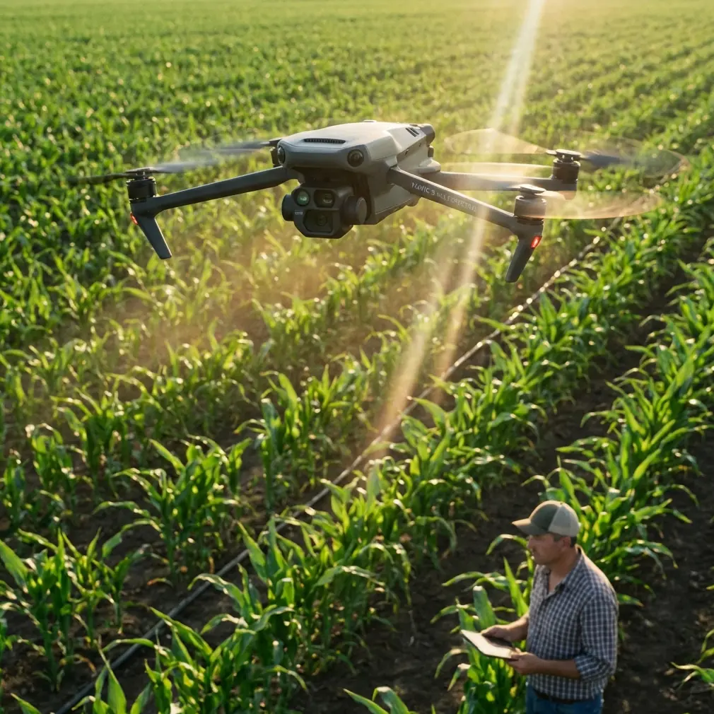
Construction site mapping requires consistent, repeatable aerial data collection—often on a rigid schedule. When wind speeds push past 20 mph, most pilots ground their drones. That's a missed deadline, a delayed progress report, and an unhappy general contractor. This case study breaks down exactly how I used the Mavic 4 Pro to complete a full 14-week aerial mapping campaign for a 47-acre mixed-use development in coastal Virginia, where sustained winds regularly exceeded 18 mph and gusts hit 28 mph.
You'll learn the specific settings, pre-flight rituals, and flight planning strategies that kept every mission safe, legal, and productive—even on days that had other pilots packing up.
The Project: Coastal Mixed-Use Development
Site Overview
The development sat on a bluff overlooking the Chesapeake Bay. The terrain included graded pads, active crane zones, partially erected steel structures, and open foundation work. Wind came predominantly from the northeast, funneling between structures and creating unpredictable turbulence pockets at 80-120 feet AGL—exactly where mapping flights needed to happen.
Deliverable Requirements
The client required:
- Weekly orthomosaic maps at 1.5 cm/px GSD or better
- Monthly 3D point clouds for volumetric earthwork calculations
- Bi-weekly progress video with smooth, cinematic quality for investor updates
- Safety documentation photos of active work zones with clear obstacle context
This meant the Mavic 4 Pro had to perform double duty: precision photogrammetry platform and cinematic video tool. Two very different demands, one airframe.
Pre-Flight Sensor Cleaning: The Step Most Pilots Skip
Here's something that doesn't make it into spec sheets: dirty obstacle avoidance sensors will sabotage your mission in wind. The Mavic 4 Pro features an omnidirectional obstacle avoidance system with sensors on all sides of the aircraft. These sensors are the backbone of safe autonomous flight, especially when ActiveTrack is engaged near structures.
On a construction site, dust is everywhere. Fine particulate from grading operations, concrete cutting, and demolition coats every surface—including your drone. Before each flight, I followed a strict cleaning protocol:
- Microfiber wipe on all vision sensors (front, rear, lateral, top, bottom)
- Compressed air on gimbal housing to prevent particulate from affecting the camera's mechanical stabilization
- Lens cleaning pen on the main camera element—fingerprints and dust spots destroy photogrammetric accuracy
- Visual inspection of propeller edges for chips or cracks that worsen vibration in wind
Pro Tip: Carry a dedicated "sensor cleaning kit" in a sealed ziplock bag inside your flight case. Construction dust is abrasive—using a dirty cloth is worse than not cleaning at all. I replace microfiber cloths every three flight days on active sites.
Skipping this step on Week 3 cost me an entire flight. The Mavic 4 Pro's obstacle avoidance system flagged phantom obstacles at 40 feet AGL, triggering repeated hover-and-hold interruptions during an automated mapping grid. A two-minute cleaning routine would have saved 45 minutes of troubleshooting.
Flight Planning for Wind: Settings That Matter
Mapping Configuration
For orthomosaic capture in wind, I locked in these parameters:
- Flight altitude: 100 feet AGL (balancing GSD requirements against turbulence layers)
- Speed: 8 mph groundspeed (reduced from typical 12 mph to compensate for wind-induced drift)
- Front overlap: 80% | Side overlap: 75%
- Shutter speed: 1/1000s minimum to eliminate motion blur from platform instability
- ISO: Auto, capped at 400 to maintain noise-free data for photogrammetric processing
- Image format: RAW (DNG)
Wind-Specific Adjustments
The Mavic 4 Pro's Sport mode offers maximum motor authority, but it disables obstacle avoidance—a dangerous trade-off near active cranes and steel structures. Instead, I flew in Normal mode with obstacle avoidance sensitivity set to "Brake" rather than "Bypass." This configuration maintained full sensor protection while still allowing the motors to work hard against gusts.
| Parameter | Calm Conditions | Windy Conditions (15-28 mph) |
|---|---|---|
| Flight Mode | Normal | Normal (not Sport) |
| Obstacle Avoidance | Standard | Brake mode |
| Groundspeed | 12 mph | 8 mph |
| Front Overlap | 75% | 80% |
| Side Overlap | 70% | 75% |
| Shutter Speed | 1/800s | 1/1000s+ |
| Battery Reserve | 25% RTH | 35% RTH |
| Max Altitude | 120 ft AGL | 100 ft AGL |
The increased overlap percentages are critical. Wind causes slight positional drift between exposures, and higher overlap gives photogrammetry software like Pix4D or DroneDeploy more tie points to work with. The result: consistent 1.2 cm/px GSD across all 14 weeks, with reconstruction accuracy within 2 cm horizontal and 3 cm vertical.
Expert Insight: Increase your battery reserve threshold by 10% in sustained winds above 15 mph. The Mavic 4 Pro's motors draw significantly more power fighting headwinds on return-to-home legs. I lost a battery to a 4% landing in Week 6 because I used my calm-weather reserve threshold. The drone made it back, but that margin was unacceptable on a site with active workers below.
Cinematic Deliverables: D-Log, Hyperlapse, and QuickShots in Wind
The bi-weekly investor videos required a completely different approach than mapping flights. The client wanted smooth, polished footage that communicated progress without looking like raw survey data.
D-Log for Maximum Flexibility
I shot all video in D-Log color profile at 4K/60fps. D-Log captures a wider dynamic range than standard color profiles, which is essential on construction sites where you're constantly dealing with bright concrete, dark shadow pockets under structures, and reflective steel. The flat color profile gave me approximately 2 extra stops of dynamic range in post-production, allowing me to recover highlight detail in concrete pours and shadow detail under formwork simultaneously.
Hyperlapse for Progress Documentation
The Mavic 4 Pro's Hyperlapse mode creates time-lapse sequences while the drone moves through space. I programmed identical waypoint paths every two weeks, producing progress Hyperlapse sequences that showed structural changes from the exact same camera angles. These became the most-requested deliverables from the investor group.
Subject Tracking and QuickShots Near Structures
ActiveTrack on the Mavic 4 Pro proved remarkably stable even in 20+ mph winds when tracking crane operations and concrete pours. The key was selecting high-contrast subjects—a bright yellow excavator against gray earth, for example—rather than asking the system to track workers in similar-colored safety vests.
QuickShots modes (Dronie, Rocket, Circle, Helix) added production value to progress videos with minimal pilot workload. The Circle mode around completed structural bays became a signature shot in every update.
Wind considerations for cinematic flights:
- Always fly crosswind or with tailwind during tracking shots—headwind segments cause visible gimbal corrections
- Use ActiveTrack 6.0's predicted path feature to smooth tracking around structural corners
- Set gimbal speed to slow to prevent jerky corrections when gusts shift the airframe
- Record 30-second buffer clips before and after each planned shot to give your editor flexibility
Common Mistakes to Avoid
1. Flying in Sport mode near structures for "better wind handling." Sport mode disables obstacle avoidance entirely. On a construction site with cranes, scaffolding, and temporary structures, this is reckless. The Mavic 4 Pro's Normal mode provides sufficient motor authority for winds up to Level 6.
2. Using calm-weather overlap settings in wind. Your mapping data will have gaps. Photogrammetry software needs redundant coverage to compensate for wind-induced positional drift. Budget for 15-20% more flight time per acre when winds exceed 15 mph.
3. Ignoring battery temperature. Cold, windy conditions drain batteries faster and reduce total available capacity. I pre-warmed batteries in an insulated bag with hand warmers during winter weeks of the project, maintaining cell temperatures above 68°F before takeoff.
4. Skipping pre-flight sensor cleaning on dusty sites. As detailed above, this single oversight causes more aborted missions than any mechanical failure. The obstacle avoidance system is your safety net—keep it clean.
5. Neglecting to log wind conditions per flight. Your photogrammetry processing parameters should adjust based on flight conditions. Without per-mission wind logs, you can't troubleshoot reconstruction errors weeks later. I recorded wind speed, direction, and gust intensity for every sortie.
Frequently Asked Questions
Can the Mavic 4 Pro reliably map in winds above 20 mph?
Yes, with adjustments. The Mavic 4 Pro is rated for Level 6 winds (25-31 mph). During this project, I consistently flew successful mapping missions in sustained winds of 18-24 mph with gusts to 28 mph. The keys are reduced groundspeed, increased image overlap, faster shutter speeds, and higher battery reserve thresholds. Above 25 mph sustained, I grounded operations—the data quality degradation and safety risk outweigh the schedule pressure.
How does D-Log compare to standard color profiles for construction documentation?
D-Log captures roughly 2 additional stops of dynamic range, which translates directly to better detail retention in both highlights and shadows. Construction sites are high-contrast environments. Standard profiles clip bright concrete and lose shadow detail under structures simultaneously. D-Log requires color grading in post-production, which adds 15-20 minutes per deliverable, but the quality difference is significant enough that every client I've worked with prefers the final output.
Is ActiveTrack safe to use on active construction sites?
ActiveTrack paired with the Mavic 4 Pro's omnidirectional obstacle avoidance system performs well near structures, but it requires pilot judgment. I never engaged ActiveTrack within 30 horizontal feet of active crane swing zones or near suspended loads. The system excels at tracking ground-level equipment and vehicles moving predictably across open areas of the site. Always maintain visual line of sight and keep your thumb ready on the control sticks to override if subject tracking pulls the drone toward an unexpected obstacle.
Final Thoughts
This 14-week project produced over 4,200 mapping images, 28 orthomosaic maps, 7 point clouds, and 7 cinematic progress videos—all from a single Mavic 4 Pro airframe operating in conditions that would have grounded less capable platforms. The combination of robust wind resistance, reliable obstacle avoidance, versatile D-Log video, and intelligent flight modes like ActiveTrack and Hyperlapse made it possible to meet every deadline without a single data gap.
The pre-flight sensor cleaning ritual took two minutes per flight. The return on that investment was zero aborted missions after Week 3. Small disciplines produce big results.
Ready for your own Mavic 4 Pro? Contact our team for expert consultation.