Mavic 4 Pro for Windy Vineyard Inspections
Mavic 4 Pro for Windy Vineyard Inspections: What Actually Matters in the Field
META: A technical review of Mavic 4 Pro workflow for vineyard inspection in windy conditions, with practical notes on obstacle avoidance, ActiveTrack, D-Log capture, and payload mounting discipline.
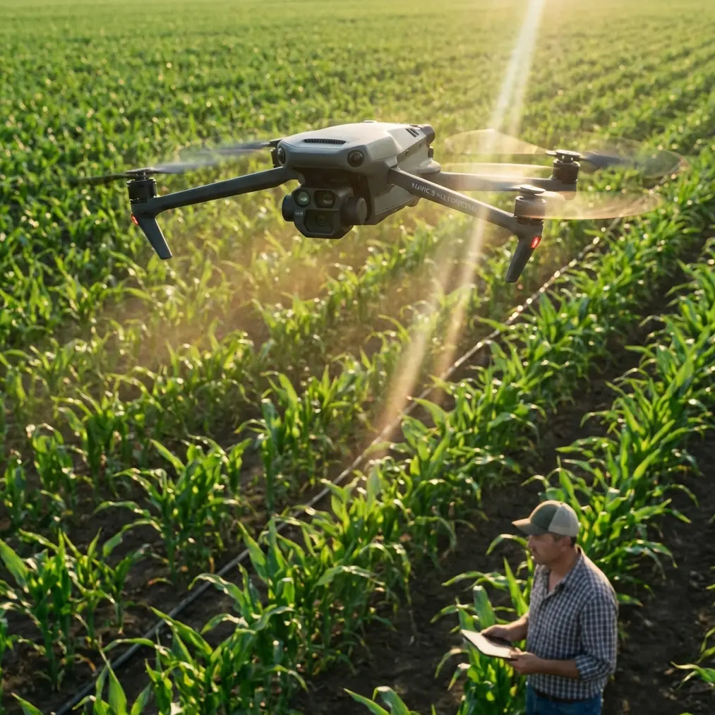
Vineyard inspection looks calm from a distance. Rows are neat, the terrain seems open, and the aircraft has plenty of room to work. In practice, windy vineyard flights are full of small penalties: cross-row gusts, repetitive geometry that can confuse your visual read of speed, reflective irrigation hardware, and the constant need to capture usable footage without wasting battery on unnecessary repositioning.
That is where a serious look at the Mavic 4 Pro becomes useful. Not as a spec-sheet exercise, but as a working tool for operators who need stable, repeatable results over agricultural blocks. If your goal is to inspect vine vigor, check trellis condition, review access roads, document irrigation issues, or create client-ready visual reports, the aircraft’s value is tied to how well it behaves when the conditions are less polite.
I approach this as a photographer first, but vineyard work forces you to think like an operator. Image quality alone is never enough. The aircraft has to hold line in wind, recover cleanly when signal conditions get messy, and help you gather footage that remains useful once you are back at the desk.
The real challenge in vineyards is not distance. It is consistency.
A vineyard can make an easy flight look harder than it should be. Long rows create a visual tunnel effect. Wind often moves differently at the edge of a block than it does above the center. If you are flying near metal fencing, utility runs, pumps, or service structures, you may also see intermittent electromagnetic interference that does not stop the mission but does demand attention.
That is why Mavic 4 Pro’s practical toolset matters more than headline features. Obstacle avoidance is not just about preventing collisions with obvious objects. In agricultural work, it helps smooth low-altitude passes near trellis ends, isolated trees, wires adjacent to access lanes, and uneven terrain transitions. Subject tracking and ActiveTrack can also be more useful here than many pilots assume. Not because you are chasing a vehicle for cinematic effect, but because a support vehicle moving along a service path can act as a repeatable reference for documenting block conditions over time.
The key is using these features selectively. Vineyard inspections reward disciplined flight plans, not blind automation.
Wind management starts before takeoff
For windy vineyard work, I usually think in three layers: route design, camera plan, and emergency discipline.
Route design means flying with the rows or diagonally across them based on the wind direction, not based on what looks cleanest on the map. If the gusts are strongest across the rows, a crosswind pass can create visible lateral drift and force the aircraft to fight harder than necessary. That wastes battery and often shows up as tiny framing inconsistencies in your footage.
Camera planning matters just as much. If I know I need inspection-grade review material as well as a more polished overview for owners or managers, I separate those tasks. I do not try to get everything in one pass. For analytical footage, I prefer slower and more stable movement. For presentation sequences, QuickShots and Hyperlapse can be useful, but only after the essential inspection data is already secured.
The emergency discipline piece is where experienced operators distinguish themselves. In windy fields, you should already know where your clean recovery areas are. Service roads, equipment bays, or open turn zones at row ends can save a mission when gusts increase or visibility starts to flatten.
Electromagnetic interference is often manageable if you react correctly
The vineyard scenario in the brief specifically mentions electromagnetic interference and antenna adjustment, and that deserves attention. EMI in agricultural settings is not always dramatic. It may appear as minor signal instability near pumps, utility lines, powered fencing systems, or clustered metal infrastructure around storage and processing areas.
When it happens, the worst response is usually overcorrection. Pilots often start pushing sticks harder, climbing aggressively, or changing direction before confirming whether the issue is aircraft positioning, temporary obstruction, or controller orientation.
A calmer response works better:
- Reassess your body position and line of sight.
- Adjust the controller antenna orientation toward the aircraft rather than assuming the aircraft itself is the problem.
- If needed, move a few steps to reestablish a cleaner signal path.
- Gain altitude moderately if terrain, vines, or nearby structures are partially masking the link.
- Avoid hovering too long near the suspected interference source.
That antenna adjustment step sounds basic, but in the field it is operationally significant. A small correction in controller alignment can restore a stable transmission path without interrupting the inspection run. In vineyards, where row geometry and support structures can already complicate visual perception, reducing unnecessary maneuvering keeps the mission safer and the footage cleaner.
If your team wants to compare field setups or workflow ideas, I’d point them to this quick operator contact: https://wa.me/85255379740
Why mounting discipline matters more than people think
The supplied reference material is not about Mavic 4 Pro directly. It comes from a GoPro HERO4 Silver manual, specifically the mounting section on page 41, and it is surprisingly relevant to vineyard drone work because it highlights a truth many operators ignore: accessory mounting is often the weakest link in an otherwise professional workflow.
The manual references a “Quick Release Buckle + Thumb Screw + Slim housing” assembly and explains that adhesive mounts need proper surface prep, room-temperature installation, and 24 hours before use. It also warns that cold or damp surfaces weaken adhesion and that wax, oil, dust, and debris reduce bond strength.
Those details matter operationally when drone teams add action cameras or supplemental viewing tools to ground vehicles, scout rigs, or support equipment used alongside a Mavic 4 Pro mission. I have seen excellent aerial teams lose useful ground-reference footage because someone rushed an adhesive mount onto a dusty vehicle panel five minutes before departure. The hardware held just long enough to create confidence, then failed once vibration and wind load combined.
The bigger point is this: professional inspection is not just about the aircraft in the sky. It is about the integrity of the entire capture system.
If you are pairing Mavic 4 Pro with support cameras for row-entry documentation, machinery observation, or synchronized ground-to-air reporting, the GoPro mounting guidance offers two hard lessons:
1. Surface preparation is not optional
The manual explicitly states adhesive mounts should only be attached to clean surfaces. Wax, oil, dust, and debris reduce adhesion. In vineyards, that is especially relevant because work vehicles are almost never pristine. Fine dust and residue are everywhere. If you are mounting a camera to a utility cart, tractor panel, or inspection vehicle, clean it properly first or choose a mechanical mount instead.
2. Environmental conditions affect reliability
The source warns against installing adhesive bases on cold or damp surfaces and says the surface should be at room temperature. That may sound unrelated to drone operations, but it directly affects support footage reliability during early morning inspections, post-rain checks, or cold-season site visits. A mount that looks secure in a cool, damp prep area may not actually be ready for field vibration.
For teams building a vineyard documentation workflow, these are not trivial details. Losing a support camera can mean losing context for aerial findings, wasting time on repeat runs, or creating gaps in client reporting.
Obstacle avoidance in vineyards is about subtle hazards, not dramatic ones
Marketing often frames obstacle avoidance around forests, cliffs, or urban structures. Vineyards present a different kind of test. Hazards are lower, narrower, and easier to underestimate. End-posts, anti-bird installations, irrigation equipment, perimeter fencing, and scattered trees around block edges do not always read as high-risk until you are flying low and fast in gusty conditions.
This is where obstacle sensing earns its place. On Mavic 4 Pro, the practical advantage is confidence during transitions—especially when moving from broad overview passes to lower inspection lines. I still would not rely on sensors as a substitute for route planning, but they can reduce the workload in tight moments and help you maintain smoother trajectories around edge infrastructure.
That smoother trajectory matters in inspection footage. Jerky corrections make visual review harder. They also distort the perception of spacing and can hide minor vine or trellis issues that would have been obvious in a more stable pass.
ActiveTrack and subject tracking are useful when used with restraint
Subject tracking in a vineyard is not about novelty. It can be a powerful documentation aid when following a slow-moving support vehicle, ATV, or walking agronomist along a row edge. Done properly, it creates a consistent visual relationship between the human inspection process and the broader aerial view.
ActiveTrack is most useful when:
- a field specialist is assessing a known issue zone,
- a vehicle is traversing access lanes to show terrain or drainage conditions,
- you need repeatable movement for comparison across multiple visits.
I would be cautious about using tracking deep inside complex row structures or near mixed obstacles in stronger wind. Automation should reduce pilot workload, not create hidden risk. The best operators treat tracking as one tool in a larger plan, not as the plan itself.
D-Log is where vineyard footage becomes more useful later
If your work ends with live observation only, any decent profile may be enough. But if you are building reports, presenting findings to owners, or comparing seasonal changes over time, D-Log becomes more valuable.
Vineyards are full of contrast traps: bright sky, reflective leaves, dark soil, shaded under-canopy areas, pale service roads. D-Log gives you more room to normalize that scene later, especially when your flight happened under harsh midday light or unstable cloud cover. For technical review, this means less clipped highlight detail and better recovery in shadowed row sections.
That flexibility is not just about aesthetics. It helps preserve visual evidence. If an irrigation leak, canopy inconsistency, or trellis alignment issue sits in a difficult lighting pocket, retaining more information in the file can make the difference between a useful record and a pretty but shallow one.
QuickShots and Hyperlapse have a place, but not at the start
For pure inspection, these are secondary. For communication, they can be excellent.
QuickShots can give vineyard managers a fast and readable overview of block layout, road access, slope changes, and adjacent infrastructure. Hyperlapse is particularly effective for showing weather movement, shadow progression, or the scale of a site over time. I like Hyperlapse most when it supports an operational message—such as how wind patterns change across a block—not when it is used just to decorate a report.
My rule is simple: capture the evidence first, then the narrative layer.
A working field setup for windy vineyard inspections
A reliable Mavic 4 Pro vineyard workflow usually looks something like this:
- Start with a high overview pass to assess wind behavior and identify any interference-prone zones near utilities or processing structures.
- Fly primary inspection lines with the wind strategy already chosen, keeping movement slow enough for usable review.
- Use obstacle avoidance as a safety net around edge hazards and transition points.
- If signal quality fluctuates, adjust antenna orientation first before making larger changes.
- Capture key sequences in D-Log if post-production or archival comparison matters.
- Use ActiveTrack only where the route is predictable and the subject adds reporting value.
- Reserve QuickShots or Hyperlapse for final documentation once the inspection work is complete.
- If using support cameras on vehicles or ground equipment, follow proper mounting procedure, including clean surfaces and adequate adhesive curing time.
That last step may sound unrelated until you lose the ground-reference angle that explains what the drone was seeing from above.
Final assessment
Mavic 4 Pro makes the most sense in vineyard inspection when you treat it as part of a disciplined observation system rather than a flying camera with extra tricks. In windy conditions, the aircraft’s real strengths are not flashy. They are steadiness, smart sensing, flexible capture options like D-Log, and a set of automated tools that can help when used with judgment.
The most overlooked lesson from the reference material is also one of the most practical: details in mounting and setup have consequences. A 24-hour adhesive cure window, a clean mounting surface, and avoiding cold or wet installation conditions may seem far removed from a drone review, yet those exact details shape whether your broader documentation workflow holds together under real field stress.
That is how I would evaluate Mavic 4 Pro for vineyard work. Not by how impressive it sounds in isolation, but by how well it supports repeatable, stable, context-rich inspection when the wind picks up and the day stops cooperating.
Ready for your own Mavic 4 Pro? Contact our team for expert consultation.