Inspecting Vineyards in Extreme Temperatures With Mavic 4 Pr
Inspecting Vineyards in Extreme Temperatures With Mavic 4 Pro: Practical Tips From the Field
META: A practical Mavic 4 Pro tutorial for vineyard inspection in extreme heat and cold, with workflow tips for safer flights, cleaner imagery, and better mapping outputs.
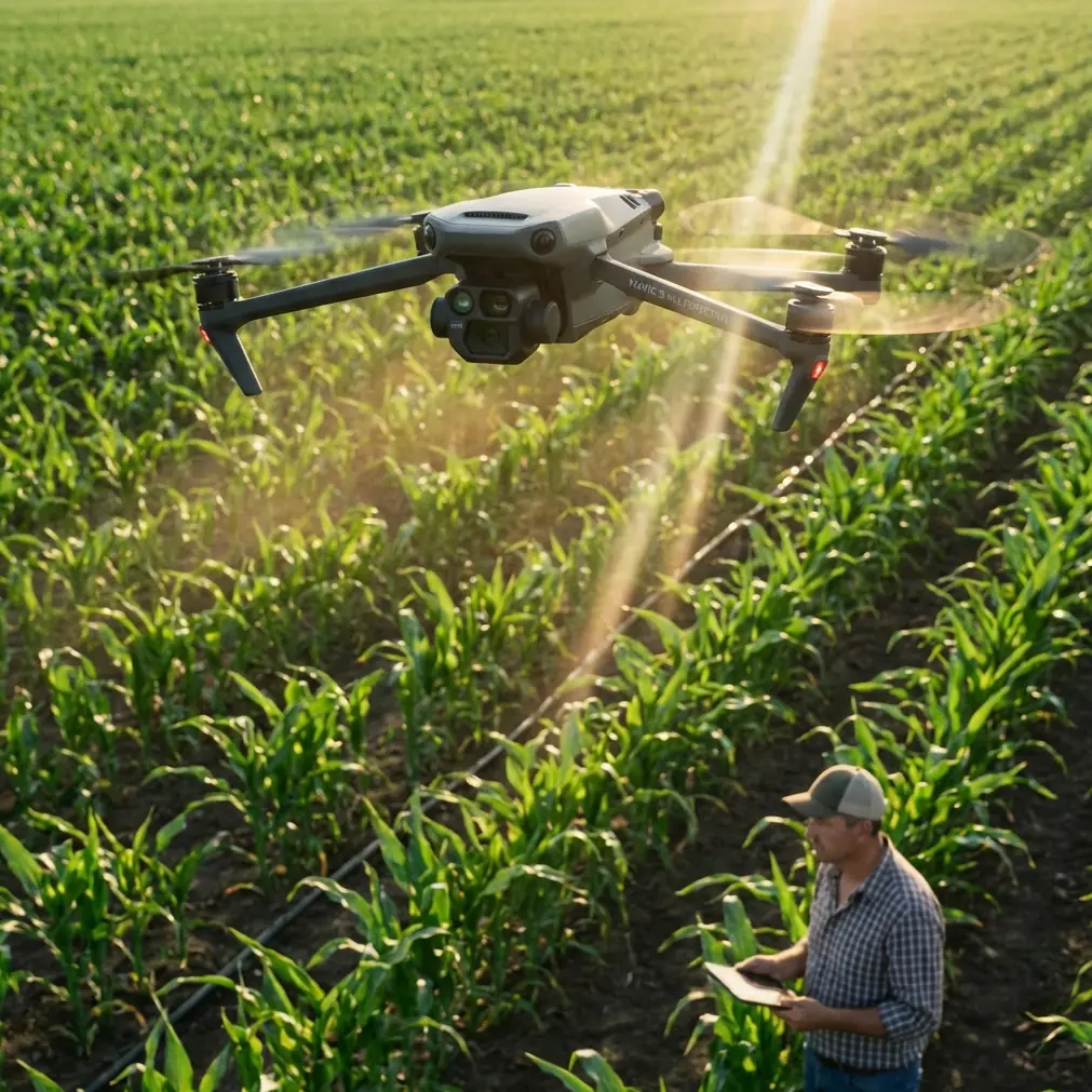
A vineyard can look calm from the ground and still be full of operational problems from the air. Heat shimmer over rows. Frost pockets hiding in low ground. Trellis lines that confuse tracking. Wind pushing across exposed slopes. And in extreme temperatures, the margin for error narrows fast.
I learned that the hard way on a summer inspection run years ago. The aircraft was fine at takeoff. Twenty minutes later, the footage was soft from atmospheric distortion, the battery behavior had changed, and the image set we hoped to use for mapping was inconsistent enough to slow the whole post-processing chain. We did get usable information, but not efficiently. That matters when you’re trying to make same-day decisions about irrigation stress, canopy uniformity, access roads, drainage, or row-end damage.
That’s the lens I’d use when looking at the Mavic 4 Pro for vineyard work: not as a flying camera alone, but as the front end of a data pipeline. If the aircraft helps you capture cleaner, more repeatable imagery under rough field conditions, the downstream work gets easier. And that downstream work is where the real value often shows up.
Start with the real job: repeatable inspection, not just attractive footage
Vineyard inspection in extreme heat or cold usually involves two different goals that get mixed together:
- Operational spotting — checking irrigation anomalies, vine vigor variation, access path issues, missing plants, storm damage, and equipment impacts.
- Structured image capture — collecting imagery that can feed mapping or photogrammetry workflows later.
The Mavic 4 Pro can serve both, but only if you separate the flight styles.
For quick problem-finding, tools like ActiveTrack, subject tracking, QuickShots, and Hyperlapse can be useful in a limited, disciplined way. They help with visual storytelling, progress records, and following vehicles or workers during non-sensitive routine operations. But for actual agronomic or infrastructure assessment, you want consistency over flair. That means measured speed, stable altitude, overlap discipline, and predictable lighting whenever possible.
The reason is simple: vineyard decisions are often made by comparing one flight against another. If your capture changes too much each time, the drone becomes less useful as an inspection instrument.
Extreme temperatures change the mission before takeoff
Most people think first about battery endurance. That’s only part of it.
In vineyards, extreme temperatures also affect:
- air density and handling feel
- atmospheric clarity and visible shimmer
- contrast across leaves, soil, and shadows
- sensor behavior during long sessions
- pilot stamina and decision quality
- how well your footage can be aligned in photogrammetry software
If you are flying in midday heat, the issue is not just reduced comfort. Hot ground can create visible distortion above the rows, especially on long oblique passes. That distortion may not ruin a casual clip, but it can absolutely reduce consistency for 3D reconstruction or orthomosaic generation.
If you’re flying in very cold conditions, the first minutes of flight can be deceptive. Controls feel crisp, visibility can be excellent, and then battery output becomes the variable you have to watch most closely. In winter vineyard inspections, I prefer shorter missions with more frequent landings rather than trying to stretch every pack.
Use obstacle avoidance as a margin, not a crutch
The vineyard environment is more complex than it looks. Wires, anti-bird netting, isolated trees, poles, wind machines, and uneven terrain can all create trouble. That’s where obstacle avoidance earns its keep. On the Mavic 4 Pro, this kind of capability matters less for “beginner confidence” and more for preserving inspection rhythm in tight working spaces.
Still, in vineyard work, obstacle sensing should be treated as a backup layer. Fine wires and netting are exactly the sort of hazards that can challenge any automated system. If you’re moving near trellis infrastructure or edge vegetation, fly as if the aircraft sees nothing. Then let obstacle avoidance save you only if your own judgment misses something.
That mindset is especially important in temperature extremes, when pilots tend to rush. In heat, they want to get the job over with. In cold, they want to get back in the vehicle. Both lead to sloppy routing.
Build two flight templates and stop improvising
For serious vineyard inspection, I recommend creating two repeatable templates.
1. The high-level scan
This is your broad situational pass. Fly higher, cover the full block, and look for:
- uneven canopy density
- waterlogging or dry areas
- erosion paths
- vehicle damage
- row interruption
- perimeter fence issues
- drainage concerns near low points
Use this flight to identify where a closer look is needed.
2. The low-altitude diagnostic pass
This is slower and more targeted. Focus on a flagged section and capture imagery with enough consistency for later review or mapping.
This is where the Mavic 4 Pro’s stabilized imaging and tracking aids can save time, but only if you keep your settings locked. If you’re changing exposure strategy every few rows, you’re making later analysis harder.
D-Log is not just for cinematic work
A lot of operators hear D-Log and think “video color grading.” That’s too narrow.
In vineyard inspection, D-Log can be useful when you’re dealing with harsh tonal contrast: bright sky, reflective soil, dark shadows under leaves, and steep slopes that catch sunlight unevenly. A flatter capture profile can preserve highlight and shadow information that would otherwise clip in more contrasty settings.
Why does that matter operationally?
Because image interpretation often depends on subtle texture and tonal differences. You may be trying to distinguish shadow from stress, dust from leaf discoloration, or compacted soil from moisture variation. A well-managed log workflow gives you more room to normalize footage later.
That said, if your team needs rapid field decisions and no one wants to color-manage footage, don’t force D-Log into every mission. Use it when the lighting is difficult and the post team can handle it. Otherwise, prioritize consistency and speed.
The hidden key: capture for processing, not just for viewing
This is where the reference material becomes more relevant than most drone buyers realize.
Advanced photogrammetry environments such as Correlator3D are built to convert aerial imagery, including drone-captured images, into usable geospatial outputs. The reference specifically notes that Correlator3D can perform aerial triangulation and generate high-density DSMs, DTMs, point clouds, orthomosaics, and vector 3D features, using GPU technology and multi-core CPU processing to handle large datasets quickly.
For vineyard operators, that has a direct implication: if your Mavic 4 Pro flight is planned well, you are not limited to simple visual inspection. You can feed those image sets into a professional workflow that supports terrain modeling, surface analysis, row structure review, and change detection over time.
That distinction matters in sloped vineyards. A standard visual pass may show general canopy issues, but a structured output like a DSM or DTM can help separate terrain-driven effects from vine-level effects. If one area appears weak, is it a plant health issue, a drainage pattern, or a terrain influence? Good geospatial products help answer that with more confidence.
Another reference system, Pixel Factory, pushes the idea further. It was described as a large-scale remote sensing image processing platform built around multiple compute nodes, management nodes, high-performance storage, and a parallel file system, with the ability to output DSM, DEM, orthophotos, and true orthophotos with limited manual intervention through parallel and automated processing.
Even if a vineyard operator never touches Pixel Factory directly, the operational lesson is valuable: data quality upstream determines how much automation you can trust downstream. If you want cleaner orthomosaics or more usable elevation products, your Mavic 4 Pro capture strategy should minimize blur, maintain overlap, control lighting variation, and avoid erratic flight geometry.
In other words, the drone flight is not the whole job. It is the acquisition stage for a larger measurement process.
Best practices for hot-weather vineyard inspection
When temperatures climb, I use a few rules that have saved more missions than any clever feature ever has.
Fly earlier than you think you need to
If you wait until the field “looks bright enough,” you may already be too late. Heat shimmer can degrade image consistency before it becomes obvious in live view.
Keep missions shorter
This helps with battery behavior, sensor temperature management, and pilot concentration. Extreme heat encourages subtle mistakes.
Avoid low oblique passes over sun-baked rows unless necessary
They can look dramatic, but they are often the first shots to suffer from visible atmospheric distortion.
Recheck focus and exposure after every battery change
Conditions can drift quickly in hot vineyards, especially over mixed terrain.
Use tracking tools selectively
ActiveTrack and subject tracking are fine for following a support vehicle or documenting a maintenance route, but I would not rely on them for core evidence capture in dense or high-contrast row environments without verifying the results.
Best practices for cold-weather vineyard inspection
Cold has a different personality. It rewards discipline and punishes assumption.
Warm your batteries before the mission window
Not excessively. Just enough that the packs are not starting the flight at the worst possible temperature condition.
Watch voltage behavior, not just percentage
Cold-weather packs can hold a reassuring number and still behave differently under load.
Don’t rush the first ascent
Give the aircraft a stable start. Abrupt changes right after takeoff in freezing conditions are unnecessary risk.
Use the clearer winter air to your advantage
Cold-season visibility can be excellent. This is often a good time to collect structured imagery for mapping, especially if foliage density is lower and terrain expression is easier to read.
QuickShots and Hyperlapse: useful, but not where the agronomy value lives
There is a place for QuickShots and Hyperlapse in vineyard operations. They can document seasonal change, support stakeholder reporting, and help estate managers visualize progress over time. A monthly Hyperlapse from the same position can actually become a very useful management record.
But if your goal is inspection in extreme temperatures, don’t confuse communication assets with analytical assets. A Hyperlapse of the valley may impress a client. A repeatable image set with consistent overlap is what supports mapping, comparison, and technical interpretation.
A simple Mavic 4 Pro vineyard workflow that works
Here’s the process I’d hand to a working team:
- Pre-plan by temperature window, not by convenience.
- Run a high scan first to identify anomalies and wind behavior.
- Mark problem zones before flying lower.
- Capture a structured low pass with consistent speed and overlap.
- Use obstacle avoidance conservatively around poles, wires, and netting.
- Choose D-Log only when the post workflow supports it.
- Export the best image set for geospatial processing, not just the prettiest clips.
- Compare flights over time, especially after heat events, frost episodes, or irrigation changes.
If your team needs help translating raw aerial capture into a more formal vineyard mapping workflow, it makes sense to discuss the processing side early rather than after the season gets busy. You can reach out directly here: message the project desk on WhatsApp.
The practical payoff
What makes the Mavic 4 Pro useful in this scenario is not one isolated feature. It’s the combination of field efficiency and data potential.
Obstacle avoidance reduces friction in cluttered vineyard environments. ActiveTrack and subject tracking help with selected documentation tasks. D-Log can preserve difficult tonal information when light is brutal. And the imagery, if captured carefully, can feed professional photogrammetry pipelines that produce outputs far beyond casual aerial viewing.
That last part is where many operators leave value on the table. The reference materials point to serious processing ecosystems: Correlator3D for drone-enabled geospatial production, and Pixel Factory for automated, parallel generation of outputs like DSM, DEM, orthophotos, and true orthophotos. Those are not abstract software terms. In vineyard operations, they represent the difference between “we flew the property” and “we created measurable, comparable information.”
The older I get in this industry, the less impressed I am by spec-sheet excitement and the more interested I am in what saves time, preserves consistency, and improves decisions under real field pressure. Extreme-temperature vineyard work is exactly that kind of test.
The Mavic 4 Pro, used properly, can make that test a lot easier.
Ready for your own Mavic 4 Pro? Contact our team for expert consultation.