Mavic 4 Pro field report: what remote venue inspections can
Mavic 4 Pro field report: what remote venue inspections can learn from a fixed-wing mapping workflow
META: A field-tested look at how Mavic 4 Pro venue inspections improve when you borrow disciplined mapping habits from the iFly U5 workflow, from sensor thinking to pre-flight cleaning and deliverables.
When people talk about the Mavic 4 Pro for remote venue inspection, the conversation usually swings toward flight convenience, image quality, or automated tracking. Useful topics, yes. But after reading through the iFly U5 fixed-wing system recommendation and its mapping workflow, I kept thinking about something else: discipline.
That document is not about the Mavic 4 Pro at all. It describes a very different aircraft class, a fixed-wing electric system designed around structured surveying work. Yet for anyone inspecting remote venues with a Mavic 4 Pro, it offers a surprisingly sharp lesson. The best inspection results do not come from clever flying alone. They come from treating the aircraft, camera, batteries, launch routine, and processing outputs as one connected system.
For a venue inspection crew, that shift in thinking matters.
I’ve seen photographers and site teams arrive at remote locations with a strong aircraft and weak workflow. They have a high-end drone, but no repeatable capture plan. They trust obstacle avoidance without checking the sensors. They collect dramatic footage but forget to document roof drainage, access roads, spectator circulation paths, and perimeter conditions in a way that an engineer or facility manager can actually use. The result looks polished and answers very little.
The iFly U5 reference points in a different direction. It is specific. It names the ground radio battery, a suction-cup antenna, a USB link from radio to computer, a 6S intelligent battery, a 25.2V 7A charger, and even a maintenance case with a hammer, level, hanging scale, handle, tools, and spare parts. That level of detail may sound mundane. It is not. It reflects an operational culture where field reliability is part of data quality.
That is exactly how I would approach a remote venue inspection with a Mavic 4 Pro.
Start with the unglamorous step: clean before you trust the aircraft
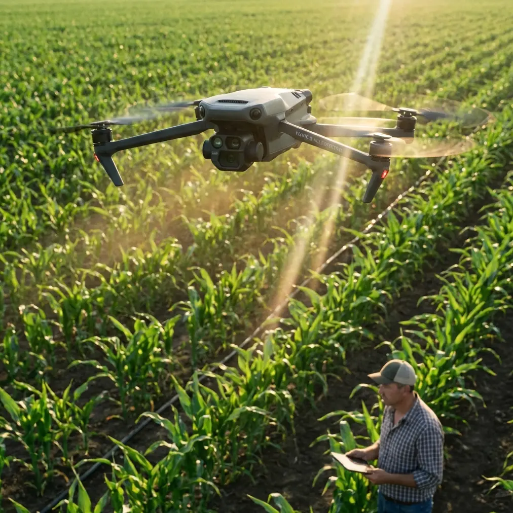
Here is the pre-flight habit I recommend to every venue inspection team using a Mavic 4 Pro: clean the vision and avoidance sensors before you power up, not after you notice inconsistent behavior.
Dust, salt film, pollen, condensation residue, and sunscreen fingerprints are common in remote outdoor venues. If you are inspecting mountain event grounds, temporary festival infrastructure, a lakeside arena, or a sports complex far from urban support, those contaminants build up fast. The Mavic 4 Pro’s obstacle avoidance and subject-aware automation are only as dependable as the data those sensors can see.
A quick wipe with a proper lens cloth takes seconds. Operationally, it changes a lot.
First, it protects confidence in obstacle avoidance when flying around light poles, truss structures, overhead cables, tree lines, bleachers, or scaffolded stages. Second, it improves the consistency of intelligent functions like ActiveTrack or other automated framing modes when you are documenting moving maintenance vehicles, staff walkthroughs, or pedestrian circulation tests. Third, it reduces the temptation to blame the drone when the real problem is a dirty sensor window.
The iFly U5 kit includes a maintenance toolbox for daily operations. That detail stood out to me. A venue inspection team with a Mavic 4 Pro should think the same way. The drone case should not just hold batteries and propellers. It should include cleaning tools, spare cloths, a blower, and a simple checklist. Reliable automation starts with clean hardware.
Why a mapping mindset improves venue inspections
The iFly U5 reference also specifies a Sony A7R camera with a 7360 × 4912 resolution, 36 million effective pixels, a full-frame 35.9 × 24 mm sensor, 4.87 μm pixel size, and a 35 mm Zeiss prime lens. On a fixed-wing mapping platform, that camera choice is not about cinematic mood. It is about predictable image geometry and detail capture that can support orthomosaics, DEM outputs, point clouds, and 3D models.
That matters for Mavic 4 Pro users because venue inspection is often trapped in a visual storytelling mindset when it should partly behave like a documentation mission.
You may not be building the same survey stack as a dedicated fixed-wing platform, but the principle carries over. When you inspect a remote venue, you need two kinds of capture:
- Decision footage — the clips and stills that quickly show stakeholders what is happening.
- Measurable context — structured, repeatable captures that help teams compare conditions across time.
This is where the Mavic 4 Pro becomes more valuable if you stop treating it as only a flying camera. Use its image quality, D-Log capture options, stabilized flight, and automated route discipline to create a record that can actually support planning. A remote venue operator may need to assess parking ingress, emergency access routes, drainage around temporary installations, fencing continuity, roof membrane condition, or terrain transitions around spectator zones. Those are not social-media shots. They are operational observations.
The iFly U5 workflow, especially the inclusion of Pix4Dmapper outputs like orthomosaics, DEM files, point clouds, and 3D models, reminds us that aerial work becomes far more useful when the data can be interpreted from more than one angle. Even if your Mavic 4 Pro mission does not end in a full mapping product, thinking in layers improves your inspection:
- A nadir pass for broad spatial context
- Low oblique passes for wall, facade, and structure review
- Targeted close inspection around problem areas
- Repeatable waypoint-style coverage for comparison over future visits
- Select cinematic clips only after the documentation baseline is secured
That order is not accidental. It keeps the inspection useful.
Remote venues expose workflow weaknesses fast
Remote work punishes improvisation. The iFly U5 package details reveal that clearly. A single 6S intelligent battery is listed. The charger is specified at 25.2V 7A. There is a dedicated ground radio battery. A launch system includes a frame, elastic cord, foot-release mechanism, and ground stake. In other words, the operator is expected to think about every stage of the mission before arriving on site.
With a Mavic 4 Pro, you do not need a catapult launcher or fixed-wing field setup, but the logic is the same. If your venue is remote, your inspection plan should answer these questions before takeoff:
- How many flights are needed for complete coverage?
- Which batteries are assigned to which capture blocks?
- What is the fallback if wind rises during the second sortie?
- Which shots are mandatory and which are optional?
- How will footage be logged for later review?
- Is the drone being used for visual inspection only, or also for terrain and access documentation?
A lot of wasted field time comes from failing to separate must-have evidence from nice-to-have visuals.
For example, if I were inspecting a remote event venue as Jessica Brown, working from a photographer’s eye but delivering for facility stakeholders, I would split the mission into four passes.
Pass 1: safety and access overview
Fly a higher perimeter route to understand road approach, parking areas, staging zones, nearby trees, utility lines, and terrain obstacles. This is where clean obstacle sensors matter immediately.
Pass 2: structural and surface review
Drop lower and examine roofs, drainage channels, facade joints, seating structures, temporary tents, lighting trusses, and fencing lines. Capture both stills and short steady video segments.
Pass 3: movement simulation
Use tracking tools carefully, including ActiveTrack where appropriate, to document how service carts or personnel move through constrained areas. This is valuable for venue logistics and event-day flow planning.
Pass 4: communication assets
Only now do I gather polished clips: Hyperlapse sequences to show site scale, QuickShots where space and safety allow, and graded D-Log footage for stakeholder presentations.
That order respects the purpose of inspection. The cinematic assets become a bonus, not a distraction.
Processing is where the job becomes useful
One of the strongest details in the iFly U5 reference is the software stack around Pix4Dmapper. The document highlights functions such as aerial triangulation and block adjustment optimized for UAVs, orthomosaic export in GeoTIFF, ground control point editing, DEM output in GeoTIFF and TXT, densified point clouds, PLY and TXT point cloud exports, 3D models in OBJ, mosaic editing tools, a fast processing mode, and automatic accuracy reports.
That list is more than software marketing. It defines what professional clients often care about after the drone lands: not the flight, but the deliverable.
Venue inspections with a Mavic 4 Pro usually stop too early. Teams download files, select a few attractive frames, and send a folder link. Better than nothing, but still thin. A stronger workflow asks: what is the client trying to decide from this inspection?
If the site owner is evaluating expansion, they need spatial context. If the operations team is preparing for seasonal reopening, they need evidence of wear and obstruction. If the venue host is coordinating contractors, they need annotated visuals showing exactly where repairs or changes are required.
That means your Mavic 4 Pro output should be organized in a way that mirrors the iFly U5 mentality:
- overview map logic
- area-by-area labeling
- issue-specific stills
- time-matched video references
- repeatable naming conventions
- summary notes tied to exact site zones
Even if you are not building a full orthomosaic on every job, the discipline of map-first organization changes the value of the final report.
If your venue team wants help structuring that kind of capture workflow, this direct planning line can be useful before you head into the field.
Image quality is not just about looking good
The Sony A7R detail in the fixed-wing reference is worth revisiting because it teaches a subtle lesson. A 36 MP sensor and 35 mm prime lens tell us the system was designed for consistency. Not for zooming in randomly. Not for dramatic perspective shifts. Consistency.
Mavic 4 Pro operators should care about that idea more than they often do.
At a venue, inconsistent focal choices can make comparison difficult. A low oblique shot from one visit and a compressed detail shot from another may both look sharp, but they do not support reliable assessment. If you are documenting roof ponding, turf wear, structural movement, or fence alignment over time, repeatability beats visual flair.
This is also where D-Log becomes practical, not trendy. In remote venues, lighting is often harsh and uneven. White roofing, dark stage coverings, reflective metal, and tree shadows can push dynamic range hard. Shooting in D-Log can preserve highlight and shadow information that later helps a manager inspect details more clearly, especially in edge cases where standard profiles clip too early.
So yes, the Mavic 4 Pro’s color and tonal flexibility matter. But not because every venue needs a cinematic film. They matter because inspection often happens under imperfect light, and recoverable detail can be the difference between guessing and seeing.
Automation should reduce workload, not reduce thinking
Features like QuickShots, Hyperlapse, obstacle avoidance, and ActiveTrack are all useful on a remote venue job when used intentionally. The mistake is assuming these features replace a capture plan.
QuickShots can quickly establish site context for reports and briefings. Hyperlapse can reveal the relationship between venue footprint, surrounding terrain, and access roads in a way a static image cannot. ActiveTrack can help document moving maintenance operations or route tests without demanding constant manual reframing.
But none of that changes the basic requirement: the pilot still needs to know what the mission is for.
The fixed-wing reference, especially the mention of automatic accuracy reporting in the processing stage, quietly reinforces this point. Professional aerial work is judged by output quality and reliability. Automation is valuable when it produces repeatable evidence, not when it simply makes flying feel easier.
The real takeaway from the iFly U5 reference
The most useful lesson the iFly U5 document offers Mavic 4 Pro users is not about hardware class. It is about operational seriousness.
A remote venue inspection works better when you borrow the habits of dedicated surveying teams:
- maintain the aircraft like a field instrument
- clean sensors before every sortie
- plan capture blocks around deliverables
- think in maps, models, and repeatable viewpoints
- organize the output so another team can act on it
The Mavic 4 Pro is perfectly capable of producing inspection material that goes beyond attractive footage. But that only happens when the operator flies with purpose.
A clean obstacle sensor may sound like a tiny detail. A structured battery and capture plan may sound overly methodical. A mapping-style output folder may feel excessive for a venue job. In practice, those are the details that separate a recreational flight from a professional inspection.
And that is the real connection between a fixed-wing mapping solution and a modern compact flagship drone: both become far more valuable when the workflow is sharper than the marketing.
Ready for your own Mavic 4 Pro? Contact our team for expert consultation.