Mavic 4 Pro for Remote Venue Inspection: What a 1
Mavic 4 Pro for Remote Venue Inspection: What a 1:500 Rural Mapping Brief Reveals About Real-World Accuracy
META: A technical review of how Mavic 4 Pro fits remote venue inspection workflows, using a 1:500 rural cadastral mapping design brief to explain accuracy, control, coordinate systems, and field efficiency.
When people talk about using a Mavic 4 Pro to inspect remote venues, the conversation usually drifts toward camera specs, obstacle avoidance, or whether ActiveTrack can follow a moving vehicle on a dirt access road. Those features matter. But they are not the part that decides whether your flight data can actually support planning, documentation, and repeatable site decisions.
A better place to start is with a real mapping standard.
One rural cadastral aerial survey design brief from Guangdong lays out a surprisingly useful framework for understanding where a Mavic 4 Pro fits in serious fieldwork. The project was built around a 1:500 scale rural land survey, covering about 5 square kilometers, with a workflow that expected 80% of mapping output from aerial survey and 20% from field补测, or ground correction and completion. That split tells you almost everything about modern drone inspection logic: fly first, fill gaps second, and never confuse good aerial coverage with finished deliverables.
For remote venue inspection, that mindset is exactly right.
Why a cadastral brief matters to venue inspection
A venue in a remote area is rarely just a “place to photograph.” It is a package of surfaces, boundaries, drainage lines, access paths, structures, temporary additions, and terrain constraints. If you are inspecting an outdoor event site, a resort expansion, a mountain retreat, a campground, or a temporary festival ground, you are dealing with a mini geospatial project whether you admit it or not.
That is why the 1:500 mapping standard in the source material deserves attention. At that scale, detail is not abstract. Small positional mistakes start to show up in access planning, fence offsets, utility alignment, pedestrian routing, and temporary structure placement. You do not need full cadastral authority for venue work, but you absolutely need cadastral discipline if the output will guide operations.
The source brief also specifies that image control point planar accuracy must not exceed ±20 mm relative to nearby basic control points. That is a strict benchmark. No one should assume a foldable drone on its own will casually deliver that outcome under all conditions. Yet this number is still useful for Mavic 4 Pro operators because it defines the tolerance culture you should bring into the mission.
In plain terms: the aircraft may be excellent, but your workflow has to be tighter than your marketing assumptions.
What the Mavic 4 Pro does well in this kind of work
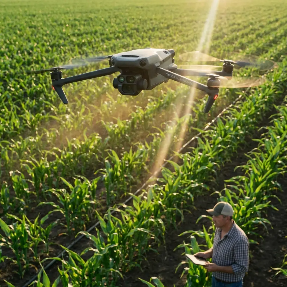
For remote venue inspection, Mavic 4 Pro makes sense when the mission sits between visual inspection and light geospatial documentation. It is portable enough to deploy from rough access points, fast enough to cover a broad site before weather shifts, and capable of collecting imagery that supports both review and reconstruction.
That balance matters in remote environments. Large aircraft can deliver endurance, but they raise logistical friction. Handheld inspection misses top-down continuity. The Mavic 4 Pro class is useful because it can move from overview capture to targeted inspection in one field session.
Obstacle avoidance is not just a convenience here. In remote venues, tree lines, utility poles, uneven slopes, guy wires, lighting rigs, and half-finished structures create the kind of clutter that punishes rushed flying. A robust sensing system reduces risk during low-altitude passes, especially when the operator has to work around reception canopies, temporary seating frames, or service roads cut into terrain.
ActiveTrack and subject tracking are often discussed as cinematic tools, but for venue work they can help document moving elements of site logistics. Think shuttle routes, maintenance vehicles, or the way service crews circulate through a compound. The key is not to treat tracking as a gimmick. Used carefully, it adds operational context to a static site model.
QuickShots and Hyperlapse are usually filed under creative features. That undersells them. A Hyperlapse sequence over a remote venue can reveal changing shadows, staging activity, parking buildup, or movement bottlenecks across time. QuickShots, when used intentionally, can create repeatable establishing views for project reporting. The value comes from consistency, not flair.
The hidden lesson in the coordinate system notes
One of the most technical lines in the reference material is also one of the most relevant. The document notes that when the total length deformation of the plane coordinate system exceeds ±25 mm/km, the system should be recalculated or an approved independent coordinate system should be used, with conversion parameters to the national system.
That sounds like bureaucratic cartography. It is not.
It is a warning that coordinate assumptions break quietly.
For remote venue inspection, especially across larger or uneven terrain, a beautiful orthomosaic can still be operationally awkward if the spatial reference is inconsistent with the rest of the project data. If the site team, civil engineer, and local survey control are not speaking the same coordinate language, drone output becomes harder to trust. Measurements drift. Overlay alignment suffers. Boundaries require manual adjustment. The data looks polished but behaves badly.
The Guangdong brief anchors its control to GDCORSS station data, using the Xi’an 1980 coordinate system for horizontal positioning and the 1985 Yellow Sea elevation datum for heights. Even if your venue project does not use those exact systems, the principle is transferable: align to the control framework that the rest of the project actually uses.
This is where Mavic 4 Pro operators can separate themselves from casual flyers. Not by saying “we captured the site,” but by asking, before takeoff, “what coordinate and elevation reference will this data need to fit into later?”
That single question saves rework.
Why “80% aerial, 20% field completion” is the right expectation
The source document’s 80/20 split is one of the most practical details in the entire brief. It reflects an honest understanding of drone data. Airborne capture is efficient, broad, and increasingly detailed. It still does not see everything.
Remote venues are full of blind spots: covered walkways, tree canopy edges, steep cuts, overhangs, utility recesses, temporary shelters, and surfaces obscured by parked equipment. A Mavic 4 Pro can drastically reduce ground effort, but it should not tempt teams into eliminating it.
This is where a third-party accessory can genuinely improve results. A high-visibility landing pad may sound basic, but on dusty, grassy, or uneven remote sites it improves startup discipline, protects the aircraft during repeated sorties, and helps maintain sensor cleanliness over a long field day. A more substantial upgrade is a tablet mount with a brighter external monitor setup, which gives the pilot and visual observer a better read on fine obstacles, glare-heavy roof surfaces, and control point visibility during planning and verification.
That kind of accessory does not make the drone smarter. It makes the operator less likely to miss small problems that turn into big ones in post.
If your work leans more heavily toward mapping, some teams also pair the aircraft with third-party ground control workflows and survey gear rather than relying purely on autonomous imagery and onboard positioning. That aligns closely with the source brief’s emphasis on GNSS RTK for control point surveying under the relevant technical standard. The operational significance is obvious: the drone gathers the visual surface efficiently, while RTK-derived control stabilizes the spatial truth behind it.
3D modeling is more than a nice extra
The original source text also references use of an intelligent 3D mapping system, SV360, to collect refined 3D models covering the topographic mapping extent. That is not a side note. It reflects where remote venue inspection becomes genuinely useful to planners.
A 2D map tells you where things are. A 3D model tells you how the place behaves.
For a venue, that distinction matters when assessing elevation changes, sightline impacts, drainage risk, temporary structure fit, façade condition, roof access, and how service routes interact with the terrain. With Mavic 4 Pro, the practical objective is not simply to make an attractive mesh. It is to capture enough structured overlap, enough perspective variation, and enough ground truth to support a model people can make decisions from.
This is also where D-Log has a quiet role. It is not just for pretty grading. In difficult contrast conditions—bright sky, dark stage roofing, reflective surfaces, deep vegetation shadows—shooting in a flatter profile can preserve visual information that helps later interpretation. For inspection, detail recovery is often more valuable than dramatic color straight out of camera.
Jessica Brown, the photographer’s perspective in this scenario, matters here. Photographers are trained to notice light. Inspectors need to notice geometry. The Mavic 4 Pro becomes much more effective when those instincts work together. You fly for overlap and measurable coverage, but you also pay attention to shadow direction, texture visibility, and reflective interference because they affect what the model can reveal.
Flight planning for remote venues: where smart features help and where they don’t
Remote site work rewards restraint. The best Mavic 4 Pro mission is rarely the flashiest one.
Use obstacle avoidance to protect the aircraft in mixed terrain and cluttered access lanes. Use ActiveTrack when movement itself is part of the inspection story. Use QuickShots for standardized report visuals. Use Hyperlapse when time variation matters. But do not confuse any of those features with a survey method.
If the venue requires deliverables that support layout, land documentation, grading review, or consultant coordination, you still need planned coverage, repeatable altitudes, sensible sidelap and overlap, and a control strategy that reflects the job’s tolerance.
The reference brief’s standards-heavy structure is useful because it reminds us that output quality comes from the whole chain: reference system, control, capture, processing, completion, and inspection. The drone is only one link.
For teams working in isolated areas, communication discipline also matters. If you need a straightforward way to coordinate deployment details, control setup, or accessory choices before heading out, this field support contact is a practical option to keep on hand.
Where the Mavic 4 Pro fits best
The Mavic 4 Pro is strongest in remote venue inspection when the mission needs all of the following at once:
- fast deployment to a hard-to-reach site
- high-quality visual documentation
- structured imagery suitable for modeling
- safe low-altitude operation around obstacles
- enough flexibility to switch between overview and detail tasks
It is less magical than some people hope and more useful than many realize.
The source mapping brief never mentions Mavic 4 Pro by name, yet it provides a much better lens for judging the aircraft than a feature sheet does. A 1:500 mapping target, ±20 mm image control point planar accuracy requirement, ±25 mm/km coordinate deformation threshold, and 5 square kilometer project area all point to the same lesson: drone work becomes valuable when you understand where precision is created, where it is lost, and what still has to be done on the ground.
That is the real standard remote venue operators should borrow.
Use the aircraft to capture the site broadly and efficiently. Respect coordinate control from the beginning. Expect field verification. Build 3D outputs that answer practical questions. Add accessories that improve reliability, not just appearance. And treat every automated feature as a tool inside a method, not a substitute for one.
That is how a Mavic 4 Pro stops being a flying camera and starts becoming a serious inspection platform.
Ready for your own Mavic 4 Pro? Contact our team for expert consultation.