Mavic 4 Pro in the Mountains: A Field Report on Inspection
Mavic 4 Pro in the Mountains: A Field Report on Inspection Workflow, Data Quality, and What Actually Matters
META: A field report on using Mavic 4 Pro for mountain venue inspection, with practical insight on obstacle avoidance, ActiveTrack, weather shifts, and why photogrammetry software choices shape the final deliverable.
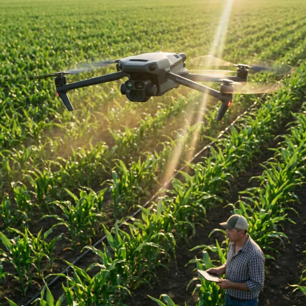
I took the Mavic 4 Pro into the mountains for a venue inspection assignment with two jobs running in parallel.
The first was visual. I needed clean, readable footage of access roads, slope transitions, tree clearance, rooflines, and the practical feel of the site from approach to perimeter. The second was more technical. The client wanted imagery that could feed a mapping and measurement workflow later, not just pretty clips for a presentation deck.
That distinction matters. A mountain venue is rarely forgiving. Light changes fast. Wind curls around ridges in unpredictable ways. Trees create broken vertical obstacles instead of neat, visible walls. And once weather starts turning, you do not get much time to rethink your flight plan.
This is where the Mavic 4 Pro conversation gets more useful if we stop treating the aircraft as a camera-only platform and start looking at the whole chain: capture, flight safety, subject continuity, and downstream processing.
The real assignment was not flying. It was decision-making.
My route started low, tracing the access path toward the venue before climbing to review the broader terrain. The site sat along a mountain shoulder, with a mix of open ground, retaining edges, utility structures, and dense tree cover. From a photographer’s perspective, it was attractive. From an inspection perspective, it was messy.
I used the Mavic 4 Pro as a field tool, not as a cinematic toy. Obstacle avoidance was one of the first features that earned its keep. In mountain work, hazards do not always announce themselves. A branch line can sit just outside your visual expectation when you are sliding laterally for a reveal shot. Terrain can rise under the aircraft faster than your framing instincts account for. A reliable avoidance system changes the way you work because it gives you room to focus on information gathering instead of constantly fighting the environment.
That does not mean you fly carelessly. It means the aircraft supports disciplined flying in places where depth cues are deceptive.
Mid-flight, the weather changed
This was the turning point of the day.
About halfway through the inspection, the conditions shifted from stable to unsettled. The clean light I had at takeoff gave way to flatter contrast, and the wind began moving across the slope in uneven pulses rather than a steady push. Clouds started cutting the ridge line and changing the exposure profile every few minutes.
In mountain inspection, those moments separate recreational flying from usable field practice. You need the drone to stay composed enough for you to keep collecting consistent material, but you also need to know when to stop trying to force the mission.
The Mavic 4 Pro handled the change well in the ways that mattered to me most. Subject tracking remained useful when I needed to keep a moving service vehicle centered along the venue approach road. ActiveTrack is often discussed as a creative feature, but in inspection work it can save attention. If the aircraft can maintain a stable relationship with the subject while you monitor wind behavior, terrain clearance, and alternate recovery paths, that is operational value, not novelty.
The same goes for controlled automated shot tools. QuickShots and Hyperlapse are usually framed around content creation, but on a site like this they can help establish repeatable visual references. A short, pre-planned orbit or elevated pullback can document surrounding vegetation, access geometry, and terrain context in a way that is easy for non-pilots to interpret later. The point is not style. The point is repeatability and communication.
Why image discipline matters more than dramatic flying
A lot of mountain venue inspections fail at the desk, not in the air.
You can come back with beautiful footage and still have weak survey support if your image set does not translate well into processing. That is where the reference material behind this discussion becomes more interesting than the typical “best drone for the mountains” angle.
One of the documents I reviewed outlines several established photogrammetry processing environments, including ImageMaster UAS, Agisoft PhotoScan, and Pix4D Mapper. Even though that source is centered on a different UAV system, the software side is directly relevant to anyone considering how Mavic 4 Pro data gets turned into actual deliverables.
ImageMaster UAS is described as a fully automated processing platform that can handle photo orientation and stereo mosaicking, automatic TIN creation and texture generation, contour and cross-section processing, orthophoto creation, 3D model display and editing, and measurement functions for points, lines, and surfaces. It also supports calculations for distance, area, and volume, with export options including RGB point cloud data, VRML, DXF, TIN, and ASCII.
That list is not just software trivia.
For a mountain venue inspection, those outputs define whether your drone flight becomes a decision-support asset or remains a folder of images. If the client needs to verify slope setbacks, estimate cleared surface area, compare parking or staging zones, or review terrain sections around proposed structures, then automatic contour and cross-section handling are immediately useful. If the project moves toward design coordination, exports like DXF and point cloud data become far more valuable than a highlight reel.
The 5 cm detail changes the conversation
Another fact from the same reference deserves attention: PhotoScan can generate high-resolution true orthophotos and, when control points are used, achieve accuracy up to 5 cm, while also producing DEM models with detailed color texture.
That 5 cm figure is the kind of detail that shifts expectations.
No, it does not mean every mountain inspection with a Mavic 4 Pro automatically becomes a survey-grade operation. Control strategy, flight planning, overlap, terrain complexity, and processing discipline still decide the result. But it does mean that the path from drone capture to measurable mapping output is real and mature. If your venue inspection may later feed planning, grading review, drainage assessment, or construction coordination, then flying with photogrammetry in mind from the start is the smarter move.
In practice, that means resisting the temptation to improvise your way through the mission. I shot visual inspection passes, yes, but I also made sure to gather image sequences that would remain coherent for later processing. Consistent overlap and stable coverage are more important than flashy perspective changes if your deliverable might become an orthomosaic or terrain model.
This is where the Mavic 4 Pro’s role becomes clearer. The aircraft is the capture end of a larger information system. The value of the drone increases when you think beyond the live monitor.
D-Log was useful for inspection, not just aesthetics
Flat profiles often get filed under “for filmmakers,” but I found D-Log helpful because the weather was moving so quickly. With cloud and sun alternating over uneven terrain, preserving tonal flexibility gave me a better chance of holding detail in darker tree lines while retaining structure in brighter open areas.
That matters for inspection footage. If the hillside vegetation becomes a crushed block of shadow, you lose visibility into edge conditions and obstacle relationships. If bright surfaces clip too hard, roof detail or path texture can disappear. D-Log gave me more room to normalize the scene afterward so the client could actually read the environment clearly.
For photographers stepping into inspection work, this is worth remembering: the best-looking image is not always the most useful image. Information density wins.
ActiveTrack in a mountain environment: where it helps and where it doesn’t
I used ActiveTrack on moving elements when I wanted continuity without manually correcting every small framing drift. On the access road, it helped keep a support vehicle centered while I watched the slope and trees. That reduced workload at a moment when the wind was already becoming less predictable.
But in a mountain venue, ActiveTrack is not a substitute for line-of-sight judgment. Tree canopies, elevation changes, and ridgeline interference can alter the geometry fast. I treated tracking as a workload reducer, not an autopilot excuse. That is the right mindset for this class of work.
The same principle applies to obstacle avoidance. It is a critical layer of protection, especially in cluttered terrain, but it works best when paired with conservative route design. I still built my passes around clear escape options and recovery directions in case the weather tightened further.
Why software compatibility should influence how you fly the Mavic 4 Pro
The reference document also highlights Pix4D Mapper as a fully automated and fast processing option capable of turning thousands of images into accurate 2D maps and 3D models without heavy manual intervention. Again, this is not just a note for office technicians.
It should influence your field habits.
If your Mavic 4 Pro mission may later be processed in software ecosystems like Pix4D, PhotoScan, or ImageMaster UAS, then your capture strategy should support automation. That means methodical image coverage, controllable flight speed, disciplined altitude changes, and avoiding unnecessary camera behavior that makes matching and reconstruction harder.
On this mountain venue job, that translated into separating creative capture from mapping capture. I did not try to make every flight segment serve every purpose. One set of passes was designed to communicate the venue visually. Another set was intended to preserve consistent geometry for possible model generation and measurement work.
That separation is one of the easiest ways to improve output quality.
The overlooked advantage: making the site understandable to non-pilots
One reason mountain inspections can stall is that drone teams sometimes deliver material that only another drone operator can interpret well.
The client does not need to be impressed by your stick work. They need to understand the site.
This is where the combination of Mavic 4 Pro capture and mature processing options can be genuinely effective. A true orthophoto, a textured terrain model, or even simple distance, area, and volume outputs can translate mountain complexity into something project managers, architects, or venue operators can use. The source material specifically mentions support for point, line, and surface measurement, as well as distance, area, and volume calculation. On a mountain property, those are not abstract software functions. They answer practical questions.
How much usable flat ground is actually available? How steep is the transition behind the event structure? How much clearance exists between trees and circulation paths? What does the venue look like as a measurable site, not just a scenic location?
If you are planning a similar workflow and want to compare practical field setups, this is a useful place to start: message the team here.
My takeaway after this flight
The mountain did what mountains do. It changed the rules halfway through.
That is exactly why the Mavic 4 Pro earned respect on this assignment. Not because the conditions were easy, but because the aircraft remained useful as the margin for error narrowed. Obstacle avoidance reduced stress in cluttered airspace. ActiveTrack helped preserve continuity when attention had to shift toward flight management. D-Log kept the footage flexible enough to remain readable after the light fell apart. And the capture itself was planned with real photogrammetry outputs in mind, informed by proven software workflows that support orthophotos, 3D models, TIN generation, contour handling, cross-sections, and measurement exports.
The biggest lesson is simple.
For mountain venue inspection, the drone is only half the story. The other half is whether your imagery can become something measurable, shareable, and trustworthy once the aircraft is back on the ground. The reference data makes that part clear. Tools like ImageMaster UAS, PhotoScan, and Pix4D Mapper show how automated processing can turn structured aerial capture into orthographic maps, textured DEMs, point clouds, and design-friendly outputs. The note about true orthophotos reaching 5 cm accuracy with control points is especially significant because it reminds us that careful field collection can support serious downstream use.
That is the standard I would apply to any Mavic 4 Pro inspection in mountain terrain.
Fly for the conditions in front of you. Capture for the decisions that come after.
Ready for your own Mavic 4 Pro? Contact our team for expert consultation.