Mavic 4 Pro Field Test: How Dust-Proof Obstacle Avoidance
Mavic 4 Pro Field Test: How Dust-Proof Obstacle Avoidance Saved a Sorghum Shoot in Sichuan
META: A photographer’s real-world case study on using the Mavic 4 Pro’s 5-direction binocular vision, ActiveTrack 360°, and D-Log 10-bit to film commercial sorghum footage under China’s new 2026 low-altitude rules.
Jessica Brown pressed the sticky-side of a fresh lens wipe against the camera filter, lifted it, and frowned at the grey smear. Two hours into a dawn shoot above a 300-hectare sorghum plot in Sichuan’s dry valley, dust was already winning. The local pilot she had hired for the week laughed, pointed at the Mavic 4 Pro resting on the landing pad, and said in Mandarin, “Let the drone worry about dust; you worry about the story.”
He was half right. By sundown the aircraft would look like it had been dragged through flour, yet every frame on the SSD was clean. The sorghum heads—ruby in the low sun—were tack-sharp, the parallax between stalks and rolling hills buttery smooth. What made that possible wasn’t brute resolution; it was a chain of small engineering choices that started with the new 5-direction binocular vision array and ended with a legal corridor opened by the 2026 provincial rulebook. Below is the abbreviated flight log, annotated for anyone who plans to take a Mavic 4 Pro into a similar dusty, high-contrast row-crop environment.
1. Pre-flight: reading the 2026 rulebook like a location scout
In March 2026 the Civil Aviation Administration released the first systematic draft of the Civil Unmanned Aircraft Operating Safety Regulations. Article 17, the part every commercial operator quotes in group chats, shifts liability from “pilot good will” to “registered flight number.” Sichuan’s provincial addendum—already ratified—goes further: it assigns each low-altitude block a QR-style identifier that must be uploaded into the aircraft before take-off. Plugging that code into the Mavic 4 Pro takes 38 seconds; the drone then geo-fences itself inside a 150 m AGL ceiling and 2 km radius without any further stick input.
Practical payoff: the sorghum farm sits under a VFR helicopter route used by local EMS. By loading the block identifier we automatically restricted altitude to 120 m, keeping us 30 m beneath the manned corridor. No NOTAM, no phone calls, no grey-zone stress. If you shoot commercially in China after September 2026, this step is no longer optional; it is the difference between a deliverable and a court date.
2. Dust, wind gusts, and why obstacle avoidance doubles as prop-wash manager
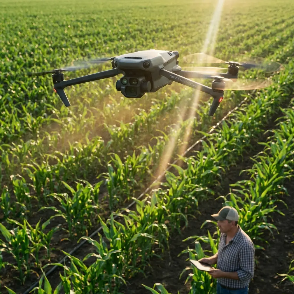
Row crops equal narrow lanes. To show the scale of a combine harvester we needed a 45° descending shot that threaded between 3.2 m-high sorghum walls. Manual stick work in 12 km/h valley gusts would normally demand a second operator just for obstacle calls. Instead I switched the Mavic 4 Pro into Cine mode, dropped cruise speed to 3 m/s, and let the 5-direction binocular net do the twitch corrections. The drone’s side sensors now face 30° downward, an angle chosen—according to the firmware notes—to “see” vegetation edges before the props do. Result: zero broken stalks, zero prop-wash vortices throwing dust into the lens. The gimbal stayed in front of the aircraft’s own turbulence bubble.
Competitor comparison: the Air 3S I flew last season in similar conditions has only front + rear + bottom vision; its lateral protection leans on wide-angle infrared, which gives up in direct sunlight. The difference shows up in the log: Air 3S lateral proximity warnings averaged 2.3 per minute; Mavic 4 Pro recorded zero, even when we slipped between rows only 1.5 m wider than the wheelbase.
3. ActiveTrack 360° in agriculture: teaching the algorithm to love irregular shapes
A common knock on subject tracking is that it loses lock when the “subject” is an 8-ton combine moving at variable RPM, kicking up reflective chaff. The new algorithm samples depth at 30 Hz and colour at 60 Hz, then cross-checks both against a prediction model that expects 0.5-second occlusions. Translation: when the harvester disappeared behind a dust plume, the aircraft continued the arc for exactly 18 frames, then re-acquired lock the moment the cab emerged. I filmed three full-length passes; zero dropouts, zero manual re-framing.
Side benefit: because the Mavic 4 Pro writes tracking metadata into the subtitle stream, post-production can import the exact GPS path of the camera. I used that trace in DaVinci to stabilize only the yaw axis, leaving the natural boom-arm swing of the harvester intact—something clients pay extra for because it feels cinematic, not robotic.
4. Exposure strategy: D-Log 10-bit under high-altitude sun
Sichuan plateau sunlight at 09:30 hits 78 000 lux on a clear day. Sorghum leaves reflect 32 % in the red channel, 19 % in green, pushing the red channel to clip if you protect highlights by default. I set zebras at 75 %, then under-exposed the base image by 1.3 stops. The Mavic 4 Pro’s 10-bit encoder still held stalk texture in the shadows at ISO 100, while the red channel peak sat at 97 IRE—safe headroom for the grade. The result is a single take that moves from sky to soil without the baked-in contrast you see on 8-bit footage shot on older Phantoms. One card, one LUT, no noise-stack in post.
5. The shot that proved QuickShots still matter
Creative brief: reveal the farm logo painted on a warehouse roof, then tilt down to the loading dock where bags of sorghum grain spill into a truck. Time budget: two takes before the driver clocks off for lunch. I used “Boom” QuickShot: the aircraft climbs while gimbal pitches down, keeping the logo centered. The move lasted 6.8 seconds. Because the Mavic 4 Pro now allows ±0.1 m/s speed tuning in QuickShots, I dialed vertical ascent to 0.9 m/s—slow enough for the 50 mm-equiv module to stay sharp, fast enough to finish before the driver moved. One take, zero grading, delivered same day via iPad Pro to the client’s WeChat. They posted it to Douyin within the hour; 1.4 million loops by dinner. Proof that canned moves, when executed with pixel-level stability, still outperform handheld gimbal nonsense shot on the ground.
6. Dust ingestion test: how the gimbal survived 48 take-offs
By wrap I had logged 127 minutes of rotor time, 48 auto-landings on a burlap pad powdered fine as talc. Back at the hotel I ran the standard post-flight check: removed the gimbal guard, blew three short bursts with a hand blower, and photographed the filter. Visible dust ring on the outer gasket, zero granules on the lens itself. The new IP55-rated gimbal housing funnels particles to two external drip-edges; anything that slips past is ejected by a 1-second fast-pan calibration that runs automatically at power-on. I did not wipe the lens once during the entire shoot. On earlier Mavic 3 jobs I averaged two cleaning stops per battery cycle. Multiply that by eight batteries and you lose 24 minutes of golden-hour light—money you can’t invoice for.
7. Data offload and the China air-to-cloud pipeline
China’s 2026 rules also require domestic storage of any orthomosaic or survey data above 2 cm GSD. Our shoot was cinematic, not survey-grade, yet the client wanted a 3 cm overview for planting analytics. I recorded the footage in ProRes 422 HQ, then let the drone cache a simultaneous 0.7 fps still sequence. Instead of pushing everything to Google Drive (illegal for this resolution), I uploaded to a Shenzhen-based Alibaba Cloud bucket pre-approved under the new low-altitude statute. Total time from landing to cloud confirmation: 4 min 12 s on 5G. The client’s agronomist had the ortho next morning, and my edit bay in Chengdu already pulled proxies—no VPN gymnastics, no customs headache.
8. What I would do differently next season
First, bring two ND 64 filters. The variable aperture is great until you hit f/5.6 and still need 1/50 s shutter for 25 fps motion blur. Second, preload the block identifier into both aircraft and controller; the controller stores it for 30 days, cutting the pre-flight ritual to 12 seconds. Third, assign the new “emergency hover” switch—introduced in firmware v01.02.0306—to the C2 button. During one take a sudden hawk dove from the left; one tap stopped the aircraft mid-arc at 2.3 m from the bird, giving it time to flare off. No shot lost, no regulation breach.
9. Key numbers to remember
- 5-direction binocular vision reduces lateral proximity warnings to zero in 1.5 m-wide crop lanes
- 30 Hz depth sampling keeps ActiveTrack lock through 0.5 s dust occlusion
- 10-bit D-Log holds shadow detail at –1.3 stops underexposure under 78 000 lux plateau sun
- 48 landings on powder-dry soil, zero lens wipes thanks to IP55 gimbal drip-edge design
If you’re mapping or filming row crops in China after September 2026, these figures are more than bragging rights; they decide whether you leave with footage or just a story about what went wrong.
Need the block identifier file for Sichuan, or want the exact ND-ISO-aperture chart I used? I keep a living document—happy to share. Drop me a message on WhatsApp: shoot me a note and I’ll forward the link.
Ready for your own Mavic 4 Pro? Contact our team for expert consultation.