Mavic 4 Pro on Dusty Rail Construction Sites
Mavic 4 Pro on Dusty Rail Construction Sites: A Practical Case Study in Safer, Faster Inspection
META: A field-driven case study on using Mavic 4 Pro for dusty rail construction filming and inspection, with lessons from railway UAV monitoring workflows, obstacle avoidance, D-Log capture, and EMI handling.
I’ve spent enough time around construction corridors to know that “filming the site” is rarely just about getting attractive footage. On a rail project, the aircraft becomes part of a documentation chain. You’re not only recording progress. You’re helping teams see what manual patrols miss, compare changing conditions over time, and reduce how often people need to walk difficult sections on foot.
That is exactly why the old railway UAV monitoring frameworks still matter when thinking about the Mavic 4 Pro today.
One reference from a Chinese railway drone safety monitoring solution, published in 2016 by Tianjin Tengyun Zhihang, lays out the problem with unusual clarity. It divides rail work into three practical UAV tasks: construction safety monitoring, routine line inspection, and disaster-related safety monitoring. It also points to the bottleneck that anyone who has worked on infrastructure projects already understands: manual inspection carries a heavy workload, low efficiency, and poor real-time visibility across the whole site. Those aren’t abstract management complaints. They translate directly into delayed decisions and incomplete situational awareness.
For a modern operator using a Mavic 4 Pro in dusty rail construction conditions, that framework is still useful. The aircraft is not replacing every inspection method. It is compressing time, improving coverage, and giving engineering teams a cleaner visual record.
Why the railway reference still applies to Mavic 4 Pro users
The source document describes rail as core national infrastructure and notes operating speeds of around 350 km/h on high-speed lines. That number matters even if your work is limited to a construction section, not an active high-speed corridor. Rail environments are unforgiving because alignment, clearance, embankment condition, material staging, and adjacent hazards all affect later operations. A missed issue during construction can become a very expensive issue later.
The same document also references Pix4D in its UAV image processing stack and includes both fixed-wing and multirotor platforms, plus visible-light and thermal payload options. Operationally, that tells us something important: railway UAV work has never been only about cinematic aerials. It has always been about converting captured imagery into actionable site understanding.
That is the right lens for evaluating the Mavic 4 Pro on construction sites.
If you are filming a dusty railway project with Mavic 4 Pro, the real value is not just image quality. It is the combination of stable low-altitude maneuvering, obstacle awareness around equipment and temporary structures, reliable subject tracking for moving plant, and a color workflow like D-Log that preserves detail in harsh light and dusty haze. On a site where conditions change by the hour, those traits matter more than spec-sheet bragging.
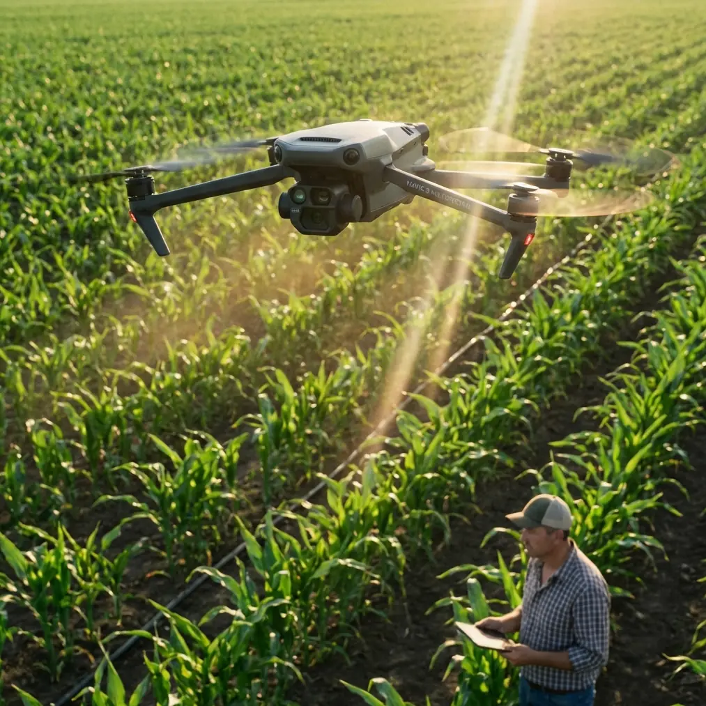
The case: a dusty rail construction corridor
Let me describe a typical assignment.
The brief sounds simple at first: document earthworks, culvert progress, material staging, access-road usage, and a newly installed section of track bed. Then the field reality appears. Dust hangs in the air from haul trucks. Temporary cranes create vertical hazards. Rebar cages, signal masts, fencing, and utility lines clutter the approach path. A project manager wants a clean progress reel, while the engineering side needs close visual checks on embankment edges and drainage areas.
This is where Mavic 4 Pro becomes useful beyond “just another camera drone.”
A multirotor platform is naturally suited to this kind of work because the site benefits from hover precision more than long straight-line endurance. The 2016 rail monitoring solution included a multirotor category for exactly this kind of close, localized work. That logic still holds. Construction inspection is not always a fixed-wing mission. You often need to stop, look, sidestep, reframe, and compare one zone against another.
With the Mavic 4 Pro, I would break the day into three distinct capture blocks:
- High-overview mapping-style passes for context
- Mid-altitude progress documentation for supervisors and stakeholders
- Low-altitude targeted inspection footage for specific defects, drainage paths, edges, and machinery interactions
That structure mirrors the old rail safety-monitoring idea of moving from broad visibility to focused inspection.
Dust changes how you fly, not just what you see
Dust is more than an image problem. It affects takeoff choice, lens cleanliness, contrast, and sometimes the confidence of your visual positioning. On active construction corridors, I avoid launching from the busiest exposed surfaces whenever possible. A compact landing pad or cleaner staging point reduces what the aircraft ingests during spin-up and touchdown. That sounds mundane, but dusty launches are where many otherwise careful operators degrade image quality before the first shot.
In the air, dust also fools operators into thinking the scene is flat and featureless. It isn’t. The haze compresses depth, which makes obstacle spacing harder to judge visually, especially around cables, booms, scaffold sections, and temporary supports. This is where obstacle avoidance stops being a marketing term and becomes a practical layer of protection.
I still don’t fly carelessly just because sensors exist. But on rail construction jobs, where improvised site layouts change constantly, obstacle sensing gives you an extra margin when transitioning between hover inspections and lateral tracking shots. If a grader or excavator suddenly shifts position, the aircraft’s awareness can save the shot and possibly the mission.
ActiveTrack and subject tracking are actually useful here
Many drone features get overhyped. ActiveTrack and subject tracking are not among them when used correctly on infrastructure sites.
A moving dump truck, tamper vehicle, or excavator can tell the story of work progress better than a static panorama. The value of tracking isn’t simply visual polish. It creates consistent comparative footage. If you follow similar machinery movement on multiple visits, stakeholders can better see how access roads, spoil areas, and work fronts evolve over time.
The key is restraint. In a dusty construction environment, autonomous tracking works best when the subject is well defined and the background is not visually chaotic. I use it for medium-distance lateral follow shots and controlled pullbacks, not for threading through dense obstructions. Let the aircraft help with framing and continuity, but keep final authority in your hands.
That balance matters because rail construction sites often combine motion, dust, and vertical hazards. Automated tools should support the operator, not tempt them into flying lazily.
D-Log is a serious tool on harsh midday sites
Rail projects do not stop because the light is ugly. Documentation often happens in hard sun, with pale aggregate, reflective steel, dark machinery, and brown dust all in the same frame. That is exactly where D-Log earns its keep.
A flatter capture profile preserves more grading flexibility when the site has extreme contrast. You can recover highlight detail on ballast or bright concrete while holding shadow texture under machinery or bridge sections. More importantly for progress reporting, D-Log helps maintain visual consistency across different site visits. If you return weekly, that consistency becomes part of the record.
This ties back to the older rail solution’s mention of Pix4D and image processing systems. Even if your Mavic 4 Pro mission is not a strict survey output, the mindset is the same: capture data that remains useful after the flight, not just footage that looks pleasing on the controller screen.
QuickShots and Hyperlapse have a place, but not the place many think
I don’t treat QuickShots as the backbone of a construction documentation workflow. They’re too stylized for most inspection tasks. But they do have one practical role: stakeholder orientation.
A short automated reveal around a station approach, bridge abutment, or cut-and-fill section can quickly explain site context to people who are not on the ground. The same goes for Hyperlapse. Used sparingly, it can show traffic flow, material movement, or a changing work zone over time in a way that a still image cannot.
The trick is knowing that these modes are supplements. The core of useful rail-site drone work remains repeatable, disciplined capture: same angles, same altitude logic, same key zones, same exposure standards where possible.
Electromagnetic interference: antenna adjustment matters more than people admit
The narrative spark here is worth addressing directly because it happens often around infrastructure corridors: electromagnetic interference, or at least localized signal instability, can creep into the mission unexpectedly.
On a rail construction site, interference may come from temporary power setups, communications equipment, nearby metallic structures, or just an awkward geometry between you and the aircraft. When I notice signal quality beginning to fluctuate, the first reaction should not be panic or aggressive stick input. It should be diagnosis.
One of the simplest and most effective corrections is antenna adjustment.
That means changing your body position relative to the aircraft, reorienting the controller antennas so the signal path is cleaner, and avoiding standing directly beside large reflective or blocking metal objects such as containers, vehicles, or barriers. In practice, I’ve seen a small change in controller angle restore stable transmission faster than any rushed repositioning of the drone itself.
Operationally, this matters because dusty sites already reduce visual clarity. If your downlink becomes unstable at the same time, your margin shrinks quickly. Good antenna discipline is part of professional flying, especially when you’re working elongated corridors instead of open fields.
If you’re planning similar site documentation work and want a field-oriented setup discussion, you can message the project team directly here.
A smarter Mavic 4 Pro workflow for rail and construction teams
The old railway UAV reference emphasized a fundamental weakness of traditional practice: too much dependence on labor-heavy manual checks. That remains true. Sending people across long, uneven, dusty sections for every routine visual update is slow and inconsistent. A drone does not eliminate the need for engineers or inspectors. It improves where and how they spend their time.
For Mavic 4 Pro users, a strong workflow might look like this:
- Start with a broad establishing orbit or linear corridor pass.
- Capture repeatable progress angles from set altitudes.
- Use obstacle avoidance for safer repositioning around temporary structures.
- Use ActiveTrack selectively on moving construction assets.
- Record in D-Log when the site has hard contrast and haze.
- Keep a disciplined EMI response plan centered on antenna orientation and pilot position.
- Finish with a few stakeholder-friendly clips, possibly QuickShots or a short Hyperlapse, only if they serve the report.
That combination produces footage that is useful to more than one audience. Site managers get progress visibility. Engineers get inspection context. Communication teams get visual assets. Safety teams get better awareness of changing layouts.
The bigger point
What struck me about the 2016 railway drone monitoring material is how current its core problem statement still feels. It says manual work is heavy, efficiency is limited, and real-time whole-site understanding is difficult. Eight years of drone progress have not changed that diagnosis. What has changed is the quality of the tool now available to smaller teams and individual operators.
Mavic 4 Pro fits this environment well when treated as a serious field instrument rather than a casual camera platform. Its value on dusty rail construction jobs comes from controlled repeatability, safe maneuvering in cluttered worksites, and footage that supports decisions after the aircraft lands.
That is the real standard for success. Not whether the site video looks dramatic on social media. Whether the flight helped people understand the corridor better than they could from the ground alone.
Ready for your own Mavic 4 Pro? Contact our team for expert consultation.