Mavic 4 Pro for Urban Solar Farm Delivery Work
Mavic 4 Pro for Urban Solar Farm Delivery Work: A Case Study in Flight Planning, Training Continuity, and Safer Low-Altitude Operations
META: A practical case study on using Mavic 4 Pro for urban solar farm delivery and inspection workflows, with flight altitude guidance, obstacle avoidance insights, and a key update on Zhejiang UAV license exam continuity.
When people talk about the Mavic 4 Pro, they usually drift toward image quality, automated modes, or headline features. That misses the point for serious operators. In urban solar farm work, the aircraft is only one part of the job. What matters is whether the whole workflow holds together: pilot training, licensing continuity, altitude discipline, obstacle handling, and the ability to document a site cleanly without interrupting operations.
That is where this case study starts.
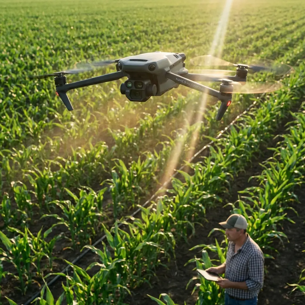
I’m framing this from the perspective of a visual operator working around distributed solar installations in urban settings, where rooftops, service alleys, light poles, HVAC clusters, cable trays, and neighboring buildings compress the available airspace. The Mavic 4 Pro is attractive in this environment because the mission is rarely just one thing. A single sortie may involve a small-payload delivery to a maintenance team, a visual inspection pass over panel rows, progress documentation for stakeholders, and a short cinematic capture for reporting. In practice, those tasks succeed or fail on operational consistency more than on brochure specs.
A recent notice from the Chinese UAV training ecosystem underscores that point. On April 18, 2026 at 23:00, the China Civil Aviation Pilots Association announced its withdrawal from providing management services for civil unmanned aircraft operator license examinations. At first glance, that sounds disruptive. For pilots, training providers, and enterprises scaling drone operations, any change tied to licensing can ripple into deployment schedules. But the operational significance of the notice is the opposite of panic: Zhejiang Province Test Site 01 remains unaffected, and all work continues normally. The service center will keep providing civil unmanned aircraft operator license examination services as usual, and Zhixiang Aviation’s qualifications and functions as the service unit for Zhejiang 01 remain unchanged.
That matters directly to Mavic 4 Pro adoption in urban solar environments.
If you are building a repeatable drone program, especially one that blends imaging and light delivery support, a stable training and examination pathway reduces friction. Teams can continue onboarding pilots, validating competency, and scheduling certification without having to freeze projects while waiting for procedural clarity. The difference between a drone that is technically capable and one that is commercially deployable often comes down to exactly this sort of administrative continuity. A reliable exam pipeline means operators can keep staffing projects, keep standardizing procedures, and keep insurance and internal compliance teams comfortable.
In urban solar farm work, I generally advise pilots to think less about “how high can I fly” and more about “what altitude gives me the cleanest margin for the specific task.” For the Mavic 4 Pro in this scenario, the useful band is often lower than newcomers expect. For close visual checks, a working altitude around 20 to 35 meters above the active roof plane or site reference can be a strong starting point. That range tends to preserve enough separation for safe maneuvering while keeping panel strings, inverter housings, conduit runs, and edge conditions legible. If the assignment is a short-range delivery to a maintenance position inside a controlled rooftop work zone, the practical altitude may tighten further, often around 15 to 25 meters during the approach segment, provided local rules, obstacles, and site SOPs allow it.
Why stay that low? Because urban solar sites are cluttered in layered ways.
Above you, there may be utility crossings, parapet overhangs, or crane activity from neighboring structures. At your level, there may be antenna arrays, access ladders, and rooftop mechanical equipment. Below you, there is the very thing you are trying not to disturb: expensive power-generation infrastructure with tight spacing and limited safe touchdown options. An aircraft like the Mavic 4 Pro becomes valuable here if its obstacle avoidance and subject tracking systems are treated as aids rather than substitutes for planning. Obstacle avoidance can help when passing near rooftop protrusions or during lateral repositioning between inspection segments, but experienced crews still build routes that avoid threading narrow corridors whenever possible.
That is one place where ActiveTrack and subject tracking can be genuinely useful in civilian field work. Not for flashy follow shots, but for maintaining visual consistency when documenting a technician’s movement across a service zone or tracking a utility cart along a pre-cleared access path. In a solar delivery workflow, that consistency helps produce footage that is easier to review later. You can see whether a handoff occurred in the right location, whether the pathway remained clear, and whether workers stayed inside the designated operational envelope. The automation is not the story. The cleaner record is.
I’ve seen crews misuse QuickShots and Hyperlapse in industrial-adjacent environments because they think every mission needs dramatic motion. It does not. But these modes still have practical value when used with restraint. A short orbit or controlled pullback can create a site-context clip that shows how a rooftop array sits relative to neighboring buildings, access roads, and staging points. Hyperlapse can support periodic progress documentation when an urban solar installation is being expanded or retrofitted. For project managers, that compressed visual record is sometimes more useful than a stack of static images, especially when communicating sequencing and access constraints to non-pilots.
The Mavic 4 Pro also makes sense for operators who need both deliverable-ready footage and usable inspection-grade visuals from the same mission day. If you’re shooting in D-Log, you preserve more flexibility for matching footage captured under the inconsistent light common in cities. Rooftop solar sites are notorious for mixed reflections: bright panel surfaces, dark equipment shadows, glass façades nearby, and changing cloud cover. D-Log gives editors and analysts more room to recover highlight detail and maintain visual consistency across separate sorties. That is not a cosmetic advantage. It improves reporting quality when footage will be reviewed by clients, engineers, or asset managers comparing site conditions over time.
Let’s make this concrete.
Imagine an urban solar farm spread across several adjoining commercial rooftops. A maintenance team needs a compact replacement part and wants to avoid repeated stairwell trips that waste labor time and disrupt building circulation. The Mavic 4 Pro is tasked with a tightly controlled rooftop transfer, followed by a visual sweep of adjacent panel rows and a short documentation package for the facility owner.
The workflow starts on the ground, not in the air. The pilot confirms that site personnel are current, documentation is in order, and the operation falls within the organization’s authorized civilian procedures. This is where the licensing update becomes more than industry noise. If your crews are operating in Zhejiang and relying on Zhejiang 01 for examination services, the recent notice indicates business continuity. Zhixiang Aviation remains in place as the service unit, and the exam service center continues functioning normally. For companies scaling inspection or rooftop support operations, that stability protects training pipelines and prevents a bureaucratic bottleneck from spilling into field deployment.
Next comes altitude selection. For the outbound rooftop segment, 25 meters may provide the best balance between obstacle clearance and visual precision. That keeps the aircraft high enough to avoid abrupt interference from railings and minor structures, but low enough that the pilot can still judge landing-zone conditions and worker positioning accurately. If neighboring towers create turbulence channels or GNSS inconsistency, the pilot may adjust downward or hold at a safer loiter point before committing to final approach. The “optimal” altitude is not fixed. It is the altitude that preserves margin while maintaining visual control and minimizing unnecessary transit over sensitive infrastructure.
On the inspection portion, the pilot shifts from transport logic to imaging logic. A pass at roughly 30 to 35 meters can reveal row alignment, visible debris zones, standing water, and access constraints. Then a lower pass at around 20 meters can capture tighter detail on suspect sections. Obstacle avoidance is useful here when backing away from rooftop equipment after a close visual check, but disciplined manual oversight remains essential because solar sites often contain thin, irregular features that are easy to underestimate in glare-heavy conditions.
What separates a smooth Mavic 4 Pro mission from an average one is the operator’s ability to think in layers. Delivery route. Visual line of sight. Worker movement. Return-to-home logic. Reflection angles. Building-induced wind behavior. Data capture requirements. A lot of pilots can fly. Fewer can integrate all of those variables without making the workflow clumsy.
That is also why training continuity should not be treated as background administration. A functioning exam and service ecosystem supports consistent pilot quality, and consistent pilot quality shows up in field outcomes: fewer rushed decisions, cleaner logs, stronger safety culture, and more reliable footage. The April 18, 2026 notice could have triggered uncertainty, yet the key takeaway for Zhejiang operators is operational steadiness. Test Site 01 is unaffected. Services continue. Qualifications and functions remain unchanged. For organizations deploying aircraft like the Mavic 4 Pro into real commercial environments, that kind of continuity is not trivial. It is part of the infrastructure behind every successful sortie.
From a photographer’s perspective, one more point stands out. Urban solar farm work rewards restraint. The best Mavic 4 Pro footage in this sector is usually not the most dramatic footage. It is the clearest. Stable framing. Repeatable angles. Predictable movement. Color profiles that hold up under review. If you use ActiveTrack, use it because it helps maintain consistency around a moving subject in a controlled zone, not because you want the aircraft making creative choices for you. If you use QuickShots, use them to establish spatial context. If you use Hyperlapse, use it to explain site progression. Every automated feature should earn its place.
And if you are building or refining this kind of workflow and need a direct line for operational discussion, you can reach out here via project coordination chat.
The broader lesson is simple. The Mavic 4 Pro fits urban solar support work well when the mission design is realistic. Keep delivery segments tight. Treat 20 to 35 meters as a practical starting altitude band for many rooftop inspection and support tasks, then adjust for site geometry and local rules. Use obstacle avoidance to add margin, not bravado. Capture in D-Log when reporting quality matters. Lean on subject tracking only where it reduces pilot workload without reducing pilot judgment. And pay attention to the training and certification ecosystem behind the aircraft, because stable exam services and unchanged site qualifications can make the difference between a paused program and a scalable one.
A drone operation is never only about the drone. In the urban solar sector, it is about the chain: trained people, functioning examination channels, disciplined altitude choices, deliberate automation, and imagery that answers operational questions. The recent Zhejiang licensing notice reinforces that the chain, at least in this case, remains intact.
Ready for your own Mavic 4 Pro? Contact our team for expert consultation.