Mavic 4 Pro Field Report: Best Practices for Remote Forest
Mavic 4 Pro Field Report: Best Practices for Remote Forest Deliveries
META: A field-tested Mavic 4 Pro guide for remote forest delivery missions, covering pre-flight cleaning, obstacle sensing reliability, air-density effects, speed management, and safer camera operations.
Remote forest delivery flights punish weak habits.
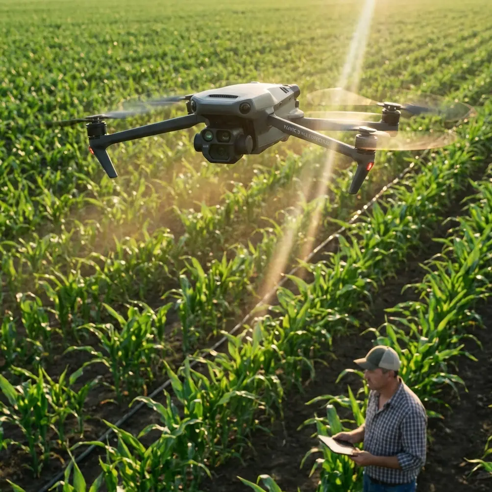
The route looks simple on a map: launch from a clearing, cross a tree line, follow a ridge, drop or document payload status, then return before weather closes the window. In practice, forests create a dense mix of visual clutter, changing airflow, moisture, shade, and elevation shifts that expose every shortcut a pilot takes before takeoff. If you are flying a Mavic 4 Pro in that environment, the difference between a smooth mission and a stressful recovery often starts with two things that seem unrelated: clean sensors and a correct understanding of lift.
That second point gets ignored too often in multirotor discussions. Pilots hear “the drone can handle it” and move on. But the physics still matter, especially when a route pushes into remote terrain where margins shrink fast.
The pre-flight step too many pilots rush: cleaning the vision system
Before I think about route logic, ActiveTrack behavior, or whether I want D-Log footage for post-mission review, I clean the aircraft.
Not casually. Deliberately.
Forest delivery work is brutal on forward, downward, and lateral sensing surfaces. Fine dust from dry tracks, moisture residue from morning fog, pollen, sap mist, and fingerprints from hasty battery swaps all degrade the inputs feeding obstacle avoidance and positioning systems. On a drone like the Mavic 4 Pro, that matters because its “intelligence” is only as good as the data reaching it.
A smudge on a sensor window does not always trigger a dramatic warning. Sometimes it just softens confidence. Tracking becomes less decisive. Obstacle avoidance hesitates near branches. Low-altitude positioning can feel less planted over uneven forest clearings. Subject tracking during follow segments may drift when contrast falls under canopy.
That is why my forest routine starts with a soft lens cloth and a full wipe-down of camera glass, vision sensors, and any exposed optical surfaces. If there is dried residue, I do not grind it into the coating. I remove grit first, then clean gently. This is a safety step, not a cosmetic one.
Operationally, that one habit supports several features people rely on heavily in wooded missions:
- Obstacle avoidance is only useful if the sensing surfaces are clear enough to interpret branches, trunks, and broken light correctly.
- ActiveTrack and subject tracking need clean optics to hold a target when the background is visually chaotic.
- QuickShots and Hyperlapse are not mission-critical for delivery, but many crews use them for route documentation, client proof-of-work, and training debriefs. Dirty sensors can undermine automated movement precision and image consistency.
A forest pilot who cleans first is usually a pilot who has fewer surprises later.
Why fixed-wing aerodynamics still matter when flying a Mavic 4 Pro
The reference material behind this piece comes from a UAV knowledge system that lays out a simple but essential truth: lift rises with airspeed and air density, and the relationship is not equal. Lift scales with the square of velocity, while its relationship to air density is linear. That distinction is not academic. It shapes how you manage a remote mission.
The source also notes that the lift coefficient, often written as CY, depends on factors such as airfoil shape and angle of attack, and that even an asymmetric airfoil can still produce lift at 0 degrees angle of attack. In other words, aircraft performance is not driven by speed alone; geometry and attitude matter too.
A Mavic 4 Pro is not a fixed-wing platform, but it is still an aircraft operating inside the same atmosphere. Its propellers are constantly generating thrust by accelerating air, and the machine’s flight controller is continually adjusting attitude to maintain stability, altitude, and forward progress. In remote forests, where elevation and airflow can change within a short route, those aerodynamic realities surface in practical ways.
Here is what that means in the field.
Dense air helps more than many pilots realize
Cool, dense morning air is usually your friend.
The source material states that lift increases with air density in a first-order relationship. In forest operations, that translates into a drone that often feels stronger and more stable in cool early conditions than it does later in the day when the air warms, thins, and starts moving unpredictably along ridges and tree gaps.
If your delivery route begins at dawn from a moist valley clearing, the Mavic 4 Pro may climb and hold with less effort than it will at midday over a sun-heated slope. That does not mean the aircraft suddenly becomes unsafe in warmer conditions. It means your performance margin narrows, especially if the route includes elevation gain, stop-start maneuvering, and any external load considerations allowed within proper civilian operating limits and manufacturer guidance.
This is one reason experienced pilots do not judge a route only by distance. They judge it by atmospheric feel.
Same path. Different hour. Different aircraft behavior.
Speed changes performance faster than many expect
The source makes a sharper point about velocity: lift is proportional to the square of speed. Double the relevant airflow term and the effect is far greater than a simple one-to-one increase.
For a Mavic 4 Pro pilot, the lesson is not “fly fast everywhere.” In forests, that would be reckless. The lesson is that energy management matters, and small speed changes can alter how the aircraft responds during transitions, climbs, and braking zones.
A drone pressing into a headwind above a tree line may need significantly more attitude and power than the same drone cruising in still air. Slow excessively during a climb-out over a canopy edge and the aircraft can begin working harder than expected to maintain vertical authority. Push too aggressively through a narrow corridor and you may create a different problem: reduced reaction time for obstacle sensing and less comfortable stopping distance near branches.
This is where pilot judgment beats feature dependence.
Obstacle avoidance is there to help. It is not a replacement for matching your speed to the corridor. In remote forest delivery, I want the Mavic 4 Pro moving briskly only where I have genuine visual confidence, GPS confidence, and a clear bailout option. In compressed terrain, controlled moderate speed is usually the better trade.
Angle, attitude, and why branch-level flying gets risky fast
The reference document also emphasizes angle of attack. It notes that lift coefficient rises with angle up to a point, then drops after a critical angle. One value cited is 16 degrees, where the lift coefficient begins to decline on the illustrated curve. That is a classic warning about aerodynamic limits.
Again, the Mavic 4 Pro is not a conventional wing relying on one fixed lifting surface, but the broader lesson carries over: pushing attitude harder does not produce endless performance. Every aircraft has thresholds where efficiency falls off and stability demands increase.
In forest delivery work, this becomes relevant when pilots try to “muscle through” bad route choices. Examples include:
- climbing sharply after entering a confined gap too low,
- accelerating under canopy and then demanding an abrupt stop,
- fighting rotor wash recirculation near dense foliage,
- asking the aircraft to hold position in turbulent edge air while also framing footage.
The drone may still recover cleanly. Or it may do that thing every experienced pilot recognizes: it starts feeling busy. More corrections. More power. Less grace.
When that happens in a remote forest, the answer is usually not more stick input. It is better planning.
Build the route around airflow, not just terrain
Forest routes are three-dimensional. Tree height is only one layer. The more subtle layer is moving air.
Ridges spill wind. Clearings create sudden exposure. Dense canopy can mask surface motion while stronger air moves just above it. A Mavic 4 Pro carrying out a remote delivery or site support mission benefits from route design that respects those transitions.
I generally divide a forest mission into four airflow phases:
Launch bubble
The air close to the takeoff point may feel calm, especially in a sheltered clearing. Do not assume the route shares those conditions.Canopy edge transition
This is often where the aircraft first meets the true wind. Expect a change in attitude and power demand.Exposed crossing
Over a gap, stream, logging cut, or ridge shoulder, the Mavic 4 Pro may encounter gusts that challenge tracking smoothness and camera steadiness.Return descent and reentry
Coming back into the sheltered zone can produce an odd sense of relief that causes pilots to relax too early. Stay disciplined through landing.
This is also where camera settings and flight settings intersect. If you are recording the mission in D-Log for later analysis, remember that flatter footage gives you more latitude in post, but it does not excuse poor exposure choices under mixed canopy light. Forests swing from bright highlights to deep shadow in seconds. If the mission includes documentation, tune for consistency before launch, not after the route gets interesting.
Feature use in forests: trust the tools, but verify the conditions
The Mavic 4 Pro platform encourages pilots to use intelligent modes because they are genuinely useful. I use them too. But remote forests are where those tools need adult supervision.
Obstacle avoidance
Treat it as a protective layer, not your primary navigation method. Branches, thin twigs, reflective wet leaves, and low-contrast scenes can all complicate detection. Clean sensors improve reliability, but they do not change the fact that natural environments are messy.
ActiveTrack and subject tracking
Excellent for following a hiker, ATV, or field technician along a known path, especially when route documentation matters. But if the target passes under dense cover or blends into shadow, monitor closely. Tracking confidence can degrade without dramatic warning.
QuickShots
Useful for training footage, site overviews, and repeatable visual records of delivery zones. In remote work, though, they belong after the safety-critical segment, not during it.
Hyperlapse
Strong for documenting changing weather over a worksite or showing logistics access conditions over time. Not something I would prioritize while managing a live remote forest delivery window.
If you need a second opinion on route planning or setup choices for this kind of mission, I’d point crews to this direct WhatsApp line for practical discussion: https://wa.me/85255379740
What the drag equation teaches a forest pilot
The source does not stop at lift. It also explains that drag, represented as D, has a coefficient CD that depends on many of the same factors, including shape and angle, and that drag rises with the same core variables of air density, area, and relative airflow.
Why does that matter to a Mavic 4 Pro operator in the woods?
Because every mission is a trade between useful progress and aerodynamic penalty.
A forest route full of stops, climbs, yaw corrections, and lateral repositioning stacks drag and power demand in ways pilots often underestimate. If your path requires constant hard corrections, the route is probably wrong. A slightly longer but cleaner line may be safer and more battery-efficient than a “direct” line through clutter.
This is one of the hidden advantages of launching with a delivery mindset rather than a cinematography mindset. The mission is not to prove the drone can squeeze through a dramatic path. The mission is to complete the work, preserve reserve battery, and come home with an aircraft that does not need luck.
My practical forest checklist for the Mavic 4 Pro
Not a generic checklist. A remote-forest checklist.
- Clean camera and obstacle sensing surfaces before every launch.
- Confirm return path is viable in worse light than departure.
- Fly the first outbound leg at a validation pace, not a hurry.
- Expect denser air and calmer handling in cooler morning windows.
- Respect performance changes as air warms or terrain elevation rises.
- Avoid relying on automation in branch-heavy, contrast-poor corridors.
- Keep enough standoff distance that obstacle avoidance is a backup, not the plan.
- Use D-Log if post-flight analysis matters, but expose for mixed forest light.
- Save QuickShots and Hyperlapse for non-critical segments.
- If the aircraft starts feeling overworked, simplify the route immediately.
The real takeaway
The Mavic 4 Pro can be an excellent tool for remote forest operations, but only when the pilot respects both the technology and the aerodynamics underneath it.
The source material highlights two details that deserve more attention in drone field practice: first, lift changes with the square of speed, which is why small changes in energy and airflow can produce outsized effects; second, air density still matters in a direct way, which is why temperature, elevation, and time of day shape how an aircraft feels on route. Add the reality that angle-related performance has limits, and you get a clearer picture of why forest missions reward restraint.
And before any of that, clean the aircraft.
A spotless sensor window will not make bad judgment good. But in a forest, dirty optics can absolutely make good judgment less effective. That is too avoidable to ignore.
Ready for your own Mavic 4 Pro? Contact our team for expert consultation.