Mavic 4 Pro Delivering Tips for High-Altitude Fields
Mavic 4 Pro Delivering Tips for High-Altitude Fields: What a Large Cargo Drone’s First Flight Teaches Small-Drone Operators
META: Practical Mavic 4 Pro tips for high-altitude field delivery planning, safety, obstacle avoidance, tracking, and workflow lessons inspired by China’s HH-200 commercial unmanned transport first flight.
I’ve spent years around cameras and aircraft, and one lesson keeps repeating itself: the bigger story in aviation often sharpens the way we fly small systems. That is exactly how I read the recent first flight of China’s HH-200 commercial unmanned transport system.
On April 15 at 9:50, the HH-200 completed its first flight and landed smoothly at the Weinan operation base of the AVIC civil aircraft flight test center. According to the report, all systems worked normally, the aircraft maintained a stable attitude, and it completed its planned test items. Before takeoff, the Civil Aviation Administration’s Northwest Regional Administration issued a special flight permit for the civil unmanned aircraft. Those details matter more than they may seem.
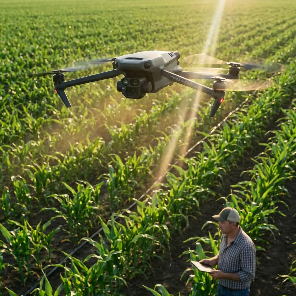
If you fly a Mavic 4 Pro in high-altitude farm country, you are obviously not operating a large cargo aircraft. But the same operating logic applies. Stable attitude. Predictable response to ground commands. Planned test items, not improvisation. Legal authorization before the mission. That framework is where reliable field delivery begins.
This article is for operators using the Mavic 4 Pro around elevated farmland, terraces, remote plots, and rugged field access points. I’m not talking about dramatic long-range fantasies. I’m talking about practical, legal, repeatable work: moving lightweight essentials, checking conditions before a handoff, documenting routes, and reducing wasted trips on foot or by vehicle.
Why the HH-200 first flight matters to Mavic 4 Pro users
The HH-200 story is not just a headline about a larger unmanned aircraft. It highlights two things every serious Mavic operator should care about.
First, system stability is the real foundation of delivery work. The report specifically says the aircraft’s systems worked normally and its flight attitude remained stable. For high-altitude field operations, that translates directly into how you configure and evaluate the Mavic 4 Pro before trusting it near crops, slopes, irrigation lines, and workers. Delivery is not mainly about speed. It is about control margins.
Second, ground-to-air coordination determines whether a mission feels easy or fragile. The pilot quoted in the source emphasized that the aircraft responded accurately and quickly to ground commands, and that air-ground coordination was smooth. On a mountain-adjacent field, that can mean the difference between a clean drop-off at a known location and a messy hover over uneven terrain while someone waves from the wrong row.
That was a hard lesson for me.
I once worked in elevated farmland where the route looked simple on a map. In reality, the field sat above a broken slope with scattered trees, netting, utility poles, and wind that changed character every 30 meters of elevation. The challenge wasn’t getting the drone out there. The challenge was arriving with enough precision and visual confidence to do something useful once it got there.
That is where the Mavic 4 Pro becomes more than a camera platform.
Start with the mission, not the aircraft
When people ask how to use the Mavic 4 Pro for field delivery support in higher terrain, I tell them to stop thinking in terms of “Can it carry this?” and start with “What exactly needs to happen at the destination?”
For most civilian field workflows, that destination task falls into one of these categories:
- confirm field access before a person climbs up
- carry a lightweight sample, document, sensor, or urgent small item
- visually verify the receiving point
- record terrain and obstacles for later route refinement
- communicate landing or handoff conditions to the ground team
The HH-200 first flight completed preplanned flight tasks, and that is the right mindset here. Every Mavic 4 Pro field delivery mission should have its own preplanned test items:
- Departure stability
- Climb performance at site altitude
- Wind behavior along the route
- Obstacle density near the field edge
- Receiver visibility
- Safe hover or handoff margin
- Return route clearance
If you cannot define those points clearly, you are not ready to send the aircraft with a payload into difficult terrain.
High-altitude fields punish lazy route planning
Higher-elevation farmland often creates a false sense of openness. It looks wide and clear from one angle, then becomes cluttered the moment you descend toward the actual working rows. Terraces, drainage cuts, low branches, fencing, bird wires, and shade cloth all begin to matter.
This is where obstacle avoidance on the Mavic 4 Pro should be treated as a backup layer, not your primary brain. In field delivery support, obstacle sensing helps most when terrain compresses your options late in the mission. Think of it as a buffer that protects you from small judgment errors, not a license to fly aggressively into clutter.
My practical rule is simple: use obstacle avoidance to preserve safety margins, but design the route as if you had to clear every hazard manually.
That means:
- approach fields from the cleanest side, not the shortest side
- avoid descending directly over workers
- keep extra separation from netting and thin wires
- build turn points before the delivery area, not inside it
- use a slower final approach than you think you need
The smoother your approach path, the less you ask the aircraft to solve all at once.
Stable attitude matters more in mountain air
The HH-200 report specifically highlighted a stable flight attitude. Small-drone operators should read that as a reminder that stability is not cosmetic. It is operational.
At higher field elevations, air can feel deceptively calm at launch and become uneven near ridge lines, irrigation channels, or sun-heated slopes. A Mavic 4 Pro holding a tidy hover over flat ground may behave differently when it crosses a contour where the wind spills downward.
So before any delivery-support mission, do a short diagnostic flight without payload assumptions driving your judgment. Watch for:
- sideways drift during hover
- yaw corrections that feel more frequent than expected
- changes in braking feel on descent
- camera gimbal micro-movements that hint at air disturbance
- inconsistent ground speed relative to stick input
If the aircraft does not look settled, the mission is already telling you something.
Use the camera system as a delivery tool, not just a recording tool
This is where my photographer background changes how I fly.
Many operators underuse the imaging side of the Mavic 4 Pro during utility work. That is a mistake. In high-altitude fields, visual confirmation is often more valuable than the transport itself. A tiny item delivered to the wrong terrace or row solves nothing.
The camera gives you three critical advantages:
1. Receiver confirmation
Before committing to the final approach, use the live view to verify the exact handoff point. In steep or layered terrain, “the upper field” is not precise enough.
2. Obstacle reading
Shadows at high sun angles can hide surface detail, while late-day light can exaggerate relief. A deliberate visual sweep often catches issues the map never showed.
3. Documentation for repeatability
If a route works, document it properly. This is where Hyperlapse and QuickShots are not just creative toys. Used carefully, they can help create fast visual references of terrain flow, approach geometry, and obstacle layout for later planning sessions. I would not use them during active handoff phases, but I absolutely use structured visual captures before or after missions to refine future routes.
That kind of repeatability is what separates casual flying from operational flying.
ActiveTrack and subject tracking: useful, but only in the right part of the workflow
A lot of pilots get excited about ActiveTrack and subject tracking because they reduce workload. In field operations, they can help, but only when used with discipline.
If a worker is moving between rows or walking toward a handoff point, subject tracking can maintain visual awareness while you keep your own attention on terrain and airspace. That is the upside.
The downside is obvious to anyone who has flown in mixed agricultural terrain: people disappear behind trees, structures, trellises, or elevation changes. In other words, tracking is a situational aid, not a substitute for route command.
I use tracking during reconnaissance, positioning, and receiver coordination. I do not rely on it for the critical final seconds of a delivery-support maneuver in a cluttered zone.
D-Log has a place in field operations too
This may sound like a photographer’s bias, but D-Log can be genuinely useful in agricultural and rural logistics workflows.
High-altitude fields often produce hard contrast: bright sky, reflective plastic coverings, dark soil, and deep shadows under trees or retaining edges. If you need to review footage later for route analysis or share mission visuals with farm managers, a flatter capture profile can preserve more usable image information for inspection.
That matters when you are trying to answer practical questions such as:
- Was the lower route actually obstructed?
- Did the worker stand under a branch line?
- Was the landing patch too uneven?
- Did glare hide a fence line on approach?
Good footage is not vanity. It is evidence for better operating decisions.
Build an air-ground coordination routine
The HH-200 pilot’s comment about smooth air-ground coordination may be the most transferable lesson of all.
When I first started working around elevated farm plots, I assumed the hard part was flying. It wasn’t. The hard part was synchronizing the people on the ground with what the aircraft was seeing.
Now I insist on a simple routine:
- one person is the receiving contact
- one exact location is agreed in advance
- visual identifiers are used if fields look repetitive
- hand signals are standardized before launch
- no one changes the pickup point without confirmation
- the pilot announces the final approach, hover, and departure
This removes confusion fast. It also reduces the temptation to improvise in the most obstacle-dense part of the mission.
If your team needs help setting up a practical field workflow, I’d suggest sharing route photos and site conditions through direct WhatsApp coordination before the mission day.
A simple Mavic 4 Pro tutorial workflow for high-altitude field delivery support
Here is the structure I recommend.
Step 1: Fly the route empty first
Do not make the first trip the real trip. Run a clean reconnaissance mission and evaluate wind, signal quality, obstacle density, and visual clarity.
Step 2: Mark the clean approach corridor
Choose the side with the fewest vertical surprises. This is usually not the most direct line.
Step 3: Verify the receiving point visually
Use zoom, framing discipline, and terrain references. Never rely on voice descriptions alone.
Step 4: Use obstacle avoidance as a margin layer
Keep it active, but still fly a conservative path with room to brake and climb.
Step 5: Slow down near the field
Fast cruise can be fine in open transit. Final approach should be deliberate and smooth.
Step 6: Avoid blind descents
If you cannot clearly read the ground and surrounding hazards, reposition first.
Step 7: Capture post-flight review footage
Use normal recording or D-Log if you expect to analyze conditions later. If the route will become routine, make a visual record of key turn points and hazard zones.
Step 8: Refine after every mission
The HH-200 first flight was meaningful because it validated systems and execution under controlled objectives. Treat every field mission the same way: as data for a better next flight.
What operators often get wrong
The most common mistake is thinking high-altitude field delivery is just ordinary drone flying with more scenery.
It isn’t.
Elevation changes distort depth perception. Repetitive crops make landmarks look interchangeable. Wind behaves differently across terraces. Workers move. The route that feels easy on the outbound leg can become awkward on return once the light shifts.
This is why that HH-200 first-flight report matters at the small-aircraft level. It reminds us that successful unmanned transport begins with disciplined execution, not bravado. A smooth landing after a successful test profile is not boring. It is the standard.
And if you’re flying the Mavic 4 Pro in field environments, that standard is exactly what you want.
The best missions are the ones that feel uneventful because every variable that could be managed was managed early. Stable systems. Accurate response to commands. Clear coordination with the ground. Planned objectives completed. Safe recovery.
That sounds like large-aircraft test language because it is. It also happens to be the right way to think about small-drone work in demanding agricultural terrain.
Ready for your own Mavic 4 Pro? Contact our team for expert consultation.