Mavic 4 Pro in the Field: What an Old Stereo
Mavic 4 Pro in the Field: What an Old Stereo-Mapping Paper Still Teaches Remote Operators
META: A field-based expert article on Mavic 4 Pro best practices for remote work, using proven stereo-mapping principles like GSD, image displacement, base-height ratio, and interference-aware flying to improve results.
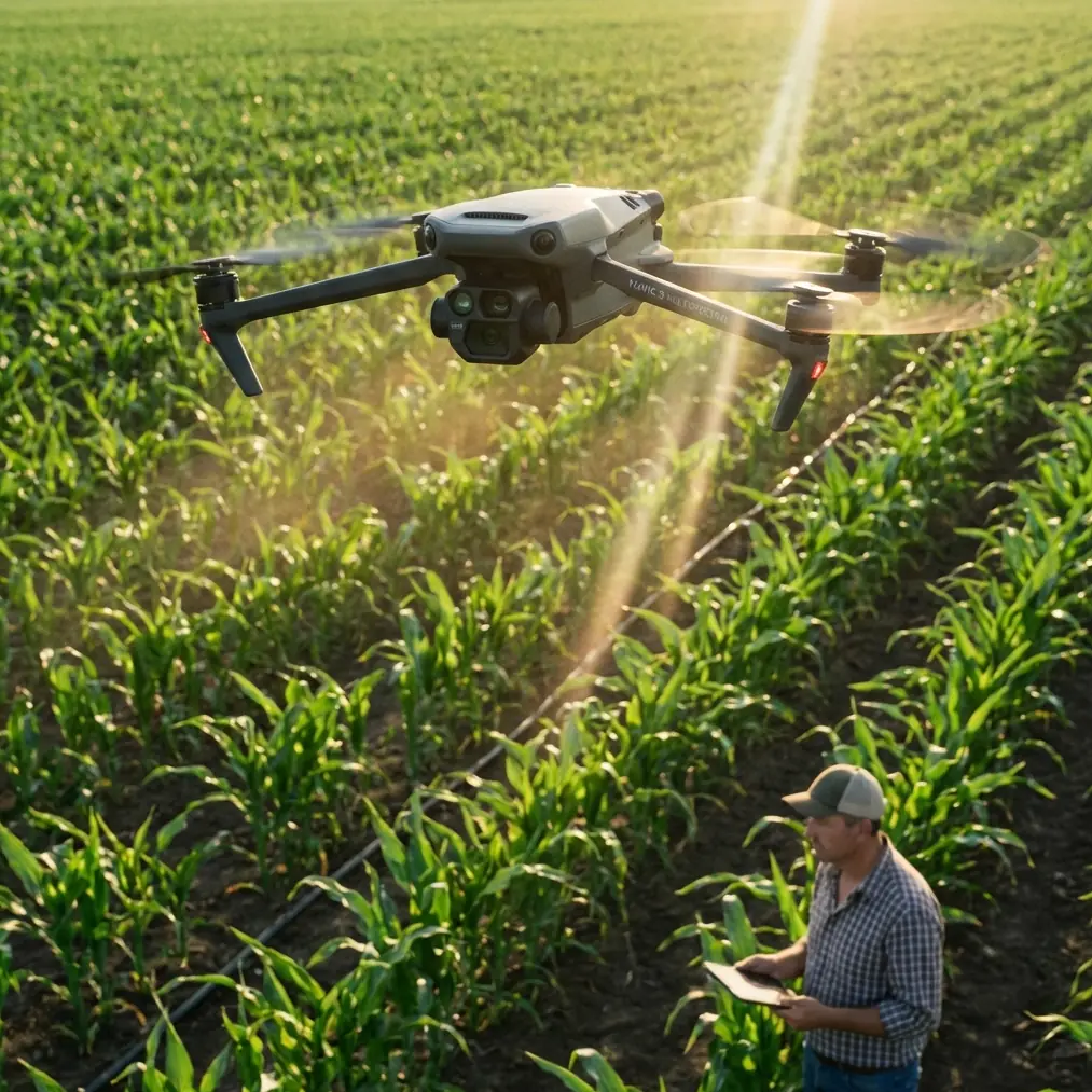
I’ve spent enough time around cameras and aircraft to know that new drones often get discussed in the wrong order. People start with headline features, then the app interface, then whatever cinematic mode is trending that month. But when you’re actually working in a remote area with a Mavic 4 Pro, the priorities shift fast. Imaging quality. Positional consistency. Flight stability. Recovery margin. Link reliability.
That is why an older geomatics paper about a civil unmanned biplane still feels surprisingly relevant.
The 2009 study, published in the Journal of Geomatics Science and Technology (Vol. 26, No. 3), described a stereo mapping aerial photography system built for small-area, large-scale topographic work. On the surface, it seems far removed from a modern compact foldable platform. The aircraft in that paper used a civil biplane airframe, a digital camera, and a 3-axis stabilized gimbal, with seven subsystems covering the aircraft, autonomous control and safety, camera payload, stabilization, air-ground wireless communication, ground station, and data processing. Different era, different form factor.
Yet the core lesson lands squarely on the Mavic 4 Pro: good field outcomes are driven less by marketing categories and more by how well the aircraft, camera, communications chain, and mission geometry work together.
For remote operators, that matters.
The real question isn’t “Can the Mavic 4 Pro film this?”
It’s “Can it deliver usable, repeatable data from a difficult site?”
That older stereo-mapping system was designed around a very specific purpose: producing aerial imagery suitable for stereoscopic survey and large-scale mapping over smaller areas. The authors didn’t treat image quality as a vague visual standard. They tied it to measurable parameters, especially GSD, image point displacement, and base-height ratio.
Those three ideas should still shape how you fly a Mavic 4 Pro in the field.
GSD decides whether your footage is merely pretty or genuinely useful
Ground Sample Distance, or GSD, is one of those terms many drone users hear once and then forget until a client asks for measurable detail. The paper directly analyzed GSD as a key parameter affecting both imaging quality and mapping accuracy. That is not academic trivia. In remote work, it determines whether you can actually identify irrigation line damage, surface washout, edge encroachment, crop variation, or construction progress with confidence.
With a Mavic 4 Pro, the operational significance is simple: altitude is not just a safety or compliance choice. It is an image-resolution decision.
Fly too high and your coverage improves, but the detail needed for field verification drops. Fly too low and the detail improves, but you may increase the number of passes, battery swaps, and stitched edges that have to behave perfectly. The old paper’s emphasis on parameter rationality is the right mindset. Don’t choose altitude because it “looks good” on screen. Choose it because the resulting ground detail matches the job.
For remote agricultural delivery planning, land inspection, or topographic reference capture, that discipline saves time later. The Mavic 4 Pro may offer polished capture modes, but the quality of the mission still begins with how much ground detail each pixel is expected to represent.
Image point displacement is the hidden destroyer of clean results
The paper also examined image point displacement in relation to imaging quality. This is where many field operators underestimate movement.
In practical terms, image point displacement shows up when the aircraft, camera, or subject geometry changes enough during capture to reduce sharpness or degrade measurement consistency. The older biplane system addressed this through a 3-axis stabilized gimbal and careful mission design. That should ring familiar to anyone flying a Mavic-class aircraft in less-than-ideal wind or terrain conditions.
On a Mavic 4 Pro, stabilization does a lot of heavy lifting, but it doesn’t suspend physics. If you are flying crosswind over an exposed field, working along tree lines that generate turbulence, or passing near metal roofing, transmission towers, solar infrastructure, or farm equipment, your margin gets thinner. Even when the video looks smooth, the imagery may not be as geometrically consistent as you assume.
This is where remote operators need to think beyond cinematic smoothness. If the mission involves site review, mapping overlap, or repeatable visual documentation, your flight speed, turn shape, yaw behavior, and gimbal angle all influence the quality of what you bring home.
The old system’s seven-subsystem architecture matters here because it reminds us that image quality is never “just the camera.” It is aircraft behavior, autonomous control, stabilization, wireless link, and processing discipline working as one chain. The Mavic 4 Pro compresses that chain into a portable platform, but the chain still exists. A weak link still weakens the output.
Base-height ratio sounds technical. In the field, it’s about depth you can trust
The paper specifically analyzed the base-height ratio as one of the key parameters for stereo mapping. For operators who don’t live in photogrammetry every day, this may sound abstract, but it has a very practical meaning: the relationship between your image spacing and flight height influences how well you can recover depth and terrain form.
That matters whenever the job goes beyond a single attractive aerial shot.
If you are documenting uneven ground, embankments, cut-and-fill activity, drainage channels, orchard row structure, or cultural heritage surfaces, the overlap pattern between images is not a side issue. It is how you preserve the information needed to interpret shape. The old paper focused on large-scale topographic mapping in small areas, and that is exactly the sort of mission where careless spacing creates expensive gaps later.
With the Mavic 4 Pro, this means you should treat repeatable interval spacing and overlap planning as part of the capture craft, not clerical setup. If the site is remote and batteries are finite, there’s a temptation to stretch each pass. That can work for general visuals. It is risky for any dataset expected to support measurements, structured review, or multi-date comparison.
The operational significance of base-height ratio is this: proper image geometry gives your footage depth utility, not just visual appeal.
Why that old biplane paper matters to a modern compact drone
At first glance, a civil unmanned biplane with short takeoff and landing capability seems disconnected from a foldable Mavic platform. It’s not.
The paper highlighted several field advantages of that aircraft type: low-altitude performance, operation without airport support, short takeoff and landing distance, and good gliding behavior. Those are all expressions of one bigger theme—field independence.
That same theme is why the Mavic 4 Pro is so valuable in remote work. You may not need a runway, but you still need the practical equivalent of self-contained deployment. A system that can be carried in, launched quickly, positioned accurately, and recovered safely without elaborate infrastructure changes what kinds of jobs are feasible.
When you’re covering remote parcels, agricultural edges, access roads, isolated utility corridors, or temporary field locations, the win is not only portability. It’s the ability to move from scouting to acquisition without dragging an entire support ecosystem behind you.
The old paper built an aerial photography system around mission-fit design and cost-performance matching. That principle should guide Mavic 4 Pro users today. Don’t configure the aircraft around online hype. Configure it around the field problem.
Remote work means electromagnetic interference is never a theoretical issue
The context for this article mentions handling electromagnetic interference with antenna adjustment, and I’d treat that as essential fieldcraft, not an extra tip.
In remote areas, people assume signal conditions will be clean because the location is far from cities. That is often wrong. High-voltage lines, telecom masts, pumping stations, solar arrays, metal sheds, perimeter fencing, even vehicles parked near your takeoff point can alter link behavior. The problem is not always total loss of signal. More often, it’s degraded stability, inconsistent telemetry updates, or a controller link that feels weaker than it should at a modest distance.
With a Mavic 4 Pro, antenna adjustment can be the difference between a calm mission and a distracted one. I don’t mean waving the controller around vaguely. I mean watching your orientation relative to the aircraft, avoiding shielding your own antennas with your body, changing your standing position if a metal structure is behind you, and re-aiming deliberately as the drone changes direction.
If the link quality drops near a specific corridor, don’t just push through. Pause and think spatially. Are you aligning the controller with the drone efficiently? Is there an obstacle reflecting or blocking? Can you move a few meters to improve the path? Are you launching too close to electrical equipment?
That habit becomes even more valuable when you’re collecting imagery meant to be stitched, compared, or reviewed as evidence of field conditions. An unstable link doesn’t just increase pilot stress. It can disrupt the consistency of the mission itself.
For operators who routinely work outside populated areas and want a practical exchange on setup habits, flight planning, or interference-aware controller positioning, I usually point them to this direct field contact option: message the team here.
Obstacle avoidance and ActiveTrack are useful, but they are not your mission plan
The Mavic 4 Pro audience often searches for obstacle avoidance, subject tracking, QuickShots, Hyperlapse, D-Log, and ActiveTrack. Those are legitimate interests. They just need context.
Obstacle avoidance is valuable in remote field work when tree lines, utility poles, terrain rise, and unplanned structures limit your margin. But it is not a substitute for route discipline. If your mapping or inspection pass depends on steady geometry, repeated automated interventions can subtly alter the line you thought you were flying.
ActiveTrack and subject tracking are excellent for documenting moving farm vehicles, monitoring site logistics flow, or creating visual progress records. But if your objective is structured site analysis, tracking behavior should be secondary to positional intent. A beautifully tracked sequence that drifts from the capture plan is still a weak deliverable for technical review.
QuickShots and Hyperlapse can serve a role too, especially for stakeholder communication. A remote client often understands site context faster through motion than through static frames. But these modes are best treated as supplements. Capture the disciplined survey or inspection material first. Then gather the interpretive visuals.
D-Log is where the photographer in me gets especially opinionated. For mixed-light environments in remote fields—bright sky, reflective water, dark vegetation, dusty roads—log capture can preserve tonal flexibility that standard looks may compress too early. The practical benefit is not artistic ego. It’s being able to recover meaningful visual separation in the final review, especially when stakeholders need to distinguish subtle surface conditions or vegetation differences.
A better way to think about the Mavic 4 Pro for remote delivery fields
If the reader scenario is “delivering fields in remote,” the temptation is to reduce the drone to route support or visual confirmation. I think that undersells it.
The smarter approach is to use the Mavic 4 Pro as a compact aerial observation system that supports decision-making before, during, and after field movement. That can include:
- pre-delivery site verification
- access route checks
- temporary obstacle identification
- terrain condition review after weather shifts
- repeat imagery for change detection
- stakeholder visuals that explain what happened on the ground
The reason the 2009 stereo-mapping paper still matters is that it framed the aircraft as a system built around use-case fit. It did not assume that “airborne camera” was enough. It considered camera stabilization, autonomous control, wireless communication, and data processing as integrated requirements. It also paid close attention to measurable image parameters like GSD and base-height ratio because those determine whether the captured imagery can support real work.
That is exactly the standard modern Mavic 4 Pro operators should hold themselves to.
Not every flight is a mapping mission. Not every field task needs stereo interpretation. But when remote conditions tighten your margin, disciplined capture geometry, interference awareness, stable communications, and camera handling become the difference between “we flew” and “we got something we can trust.”
That’s the field report version of the story.
The aircraft may be newer. The screen may be brighter. The automation may be smoother. But the fundamentals have not changed nearly as much as people think.
Ready for your own Mavic 4 Pro? Contact our team for expert consultation.